Houston Metro
The Metropolitan Transit Authority of Harris County (stylized as METRO) is a major public transportation agency based in Houston, Texas, United States. It operates bus, light rail, bus rapid transit, HOV and HOT lanes, and paratransit service (under the name METROLift) in the city as well as most of Harris County. It also operates bus service to two cities in Fort Bend County, and to Conroe in Montgomery County. The Metro headquarters are in the Lee P. Brown Administration Building in Downtown Houston. In 2023, the system had a ridership of 77,189,800, or about 232,800 per weekday as of the fourth quarter of 2023.
| Metropolitan Transit Authority of Harris County | |
|---|---|
| Overview | |
| Locale | Houston, Texas, U.S. |
| Transit type | Bus, light rail, paratransit, express lanes |
| Number of lines | 83 local bus routes 31 commuter bus routes 3 light rail lines 1 community connector 1 bus rapid transit line |
| Number of stations | 44 (light rail) 12 (bus rapid transit) 27 (park and rides) 21 (transit centers) |
| Daily ridership | 232,800 (weekdays, Q4 2023)[1] |
| Annual ridership | 77,189,800 (2023)[2] |
| Headquarters | 1900 Main St. Lee P. Brown Administration Building Downtown Houston, Texas |
| Website | ridemetro |
| Operation | |
| Began operation | January 1, 1979 (45 years ago) |
| Number of vehicles | 1,233 (bus) 76 (light rail)[3] |
History
The Texas State Legislature authorized the creation of local transit authorities in 1973. In 1978, Houston-area voters created Metro and approved a one-cent sales tax to support its operations. Metro opened for business in January 1979, taking over the bus service owned by the City of Houston known as HouTran. HouTran was plagued by outdated equipment, infrequent service and a route structure which failed to account for Houston's rapid population growth.[4]
Metro's service area encompasses 1,285 square miles (3,330 km2)[5] and also serves portions of an eight-county region with its vanpool service; the agency employs about 3,800 people.[4]
Executive leadership
Tom Lambert is the current President and CEO of the agency. Lambert was formally appointed in February 2014, although he had been operating as the agency's interim CEO since the beginning of 2013.[6] Lambert, a Houston native with a political science degree from Southwest Texas State University and master's in public administration from the University of Houston, joined Metro as a security investigator in 1979. He was named agency police chief in 1982, ultimately overseeing close to 100 officers, then moved into higher ranks of management.[7]
The Metro Board has nine members – five are appointed by the Mayor and confirmed by Houston City Council, two are appointed by Harris County Commissioners Court, and two are appointed by the 14 mayors of Metro's smaller city members.
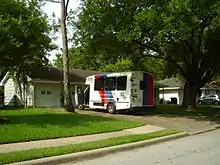
Metro Bus
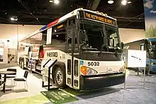
.jpg.webp)
Metro's local bus service usually runs on city streets, typically stopping at every other corner along its entire route. The bus system is the most used in Texas and the Southwest region. Metro also operates express bus routes on the Houston region's freeway high-occupancy vehicle lanes, which stop at park-and-ride lots.
Prior to the construction of Metrorail, Metro consisted of the largest all-bus fleet in the United States, only because Houston was the largest major city devoid of any rail transit since 1990.
Circa 1991 bus services for handicapped people were implemented.[8]
In 2015, the bus system was redesigned, eliminating low-ridership routes in favor of a high-frequency, high-demand bus network. This change was accomplished without any increase in operating costs.[9]
Service types
- Local: Most Metro buses typically operate on city streets, with the majority of routes serving several of Houston's major employment centers. The routes are grid-like "crosstown" routes that travel from one part of the city to another, typically without entering downtown. Many routes were truncated to METRORail stations to eliminate duplicate service.
- Express: A local limited stop service that serves key destinations but travel nonstop on freeway segments. They were formerly categorized as Limited prior to the 2015 restructuring of bus routes.
- Park and Ride (Commuter): Metro operates express service between major destinations and outlying areas via high-occupancy vehicle lanes on regional freeways. Buses on these routes stop at park-and-ride lots, which also serve as transit centers.
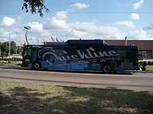
- Bus Rapid Transit: A pilot program introduced on June 1, 2009, to provide faster service with upgraded buses and fewer, more modern stops to busy corridors, beginning with a supplement of Route 2 (Bellaire), 402 Quickline Bellaire BRT. The second route in this system was a replacement of Route 33 (Post Oak), 433 Silver Line Post Oak BRT, which unlike Route 402, utilizes an exclusive busway for a majority of the route. The next planned line is the University Line, which is planned to start construction in 2025 and open in 2029.
Routes
Metro's bus routes are numbered based on their service type and arranged in a grid. On August 24, 2015, Metro revamped their entire bus network with new routes and frequent service.[10] Under the new network, all local routes run 7 days a week with the exception of two express routes.
Metro provided the free Greenlink shuttle services in Downtown Houston, but discontinued the service in March 2020 due to the COVID-19 pandemic.[11]
Metro's express and commuter buses consist of 45-foot (14 m) MCI and New Flyer "Viking" buses, which have reclining seats, small individual lights, as well as small air conditioning vents for each seat. Viking buses went out of service in May 2015. In 2023, the bus system had a ridership of 61,171,600, or about 182,900 per weekday as of the fourth quarter of 2023.
List of routes
- 2-99: Local routes
- 102-162: Express routes
- 202-298: Park and Ride routes
- 309-399: Shuttle and curb2curb routes
- 402, 433: Bus rapid transit (BRT) routes
- Red indicated 15 minute-or-better frequencies
- Blue indicated 15-30 minute frequencies
- Green indicates 30-60 minute frequencies
- Yellow indicates express bus routes
- Gray indicates Park & Ride express routes or shuttles with no defined frequency
- Coral indicates BRT (bus rapid transit) routes
Multiple colors indicate that portions of the route have different frequencies from one another. Italics indicate former routes.
| Route # | Route Name | Terminal 1 | Terminal 2 | via | Length | Ridership (FY 2023)[12] | Notes |
|---|---|---|---|---|---|---|---|
| 1 | Hospital | Eliminated in 2015 due to new route system | |||||
| 2 | Bellaire | Old Braeswood Texas Medical Center Transit Center |
Juniper Point Mission Bend Transit Center |
Bellaire Blvd (Holcombe Blvd) | 14.3 miles (23.0 km) | 1,937,131 | [13] |
| 3 | Langley-Little York | Fairbanks/Northwest Crossing Hollister Street & Little York Road |
Northside Village Burnett Transit Center |
W Little York Rd | 27.2 miles (43.8 km) | 518,411 | |
| 3 | West Gray | Section eliminated in 2015 due to new route system | |||||
| 4 | Beechnut | Greater Eastwood Eastwood Transit Center |
Juniper Point Mission Bend Transit Center |
Beechnut St, N Braeswood Blvd | 22.3 miles (35.9 km) | 2,105,502 | |
| 5 | Kashmere | Section eliminated in 2015 due to new route system | |||||
| 5 | Southmore | Midtown Wheeler Transit Center |
Allendale Flagstone Terrace and South Richey Street |
Southmore Blvd, Griggs Rd, Long Dr | 14.8 miles (23.8 km) | 325,940 | |
| 6 | Jensen/Greens | Downtown Downtown Transit Center |
Greater Greenspoint Greenspoint Transit Center |
Jensen Dr, Greens Rd | 25.6 miles (41.2 km) | 968,350 | |
| 7 | Tanglewood | ||||||
| 7 | West Airport | Willow Meadows West Loop Transit Center |
Greater Fondren Southwest Fondren Meadow Drive & Gessner Road |
Airport Blvd | 6.3 miles (10.1 km) | 211,315 | |
| 8 | West Bellfort | South Main Fannin South Transit Center |
Greater Fondren Southwest West Bellfort Park and Ride |
Bellfort Avenue (West) | 10.3 miles (16.6 km) | 856,180 | |
| 8 | South Main | Eliminated in 2015 due to new route system | |||||
| 9 | Gulfton/Holman | Greater Eastwood Eastwood Transit Center |
Sharpstown Bonhomme Road & Clarewood Drive |
Holman St, US 59, Gulfton St | 15.5 miles (24.9 km) | 622,242 | |
| 9 | North Main | Section eliminated in 2015 due to new route system | |||||
| 10 | Willowbend | Old Braeswood Texas Medical Center Transit Center |
Greater Fondren Southwest Sandpiper Drive & Willowbend Boulevard |
Holcombe Blvd, Stella Link Rd, Willowbend Blvd | 9.1 miles (14.6 km) | 162,358 | |
| 11 | Almeda/Lyons | Central Southwest Hiram Clarke Transit Center |
Northshore Dividend Street & Currency Street |
Almeda Rd, Lyons Av | 21.6 miles (34.8 km) | 648,627 | |
| 11 | Nance | Section eliminated in 2015 due to new route system | |||||
| 12 | Allen House | ||||||
| 13 | Plaza del Oro Circulator | ||||||
| 13 | Westridge | Was shown the Reimaging Side By Side map but was absorbed into 84 in the New Bus Network release | |||||
| 14 | Hiram Clarke | Old Braeswood Texas Medical Center Transit Center |
Central Southwest Hiram Clarke Transit Center |
Main St, Hiram Clarke Rd | 9.5 miles (15.3 km) | 453,014 | |
| 15 | Fulton | ||||||
| 16 | Memorial | ||||||
| 17 | Gulfton | ||||||
| 18 | Kirby | Eliminated in 2015 due to new route system | |||||
| 19 | Wilcrest | Eliminated in 2015 due to new route system | |||||
| 20 | Canal/Memorial | Bellaire Chimney Rock Road & Bellaire Boulevard |
Magnolia Park Magnolia Park Transit Center |
S Rice Av, Memorial Dr (East), Canal St | 18.7 miles (30.1 km) | 596,206 | |
| 21 | Northshore Limited | ||||||
| 22 | Almeda | ||||||
| 23 | West 43rd | Northline Northline Transit Center |
Spring Branch Central Pitner Road & Roma Street |
West 43rd St | 9.1 miles (14.6 km) | 132,918 | |
| 24 | Kempwood | ||||||
| 24 | Northline | Eliminated in 2015 due to new route system | |||||
| 25 | Richmond | Greater Eastwood Eastwood Transit Center |
Westchase Meadowglen Lane & Hayes Road |
Wheeler Ave, Richmond Ave | 17.8 miles (28.6 km) | 1,863,966 | |
| Juniper Point Mission Bend Transit Center |
20.9 miles (33.6 km) | ||||||
| 26 | Long Point/Cavalcade | Houston Gardens Kashmere Transit Center |
Memorial City Memorial City Way & Barryknoll Lane |
Cavalcade St (East 20th St), Long Point Rd | 17.4 miles (28.0 km) | 992,040 | |
| 26 | Outer Loop | Eliminated in 2015 due to new route system | |||||
| 27 | Inner Loop | Eliminated in 2015 due to new route system | |||||
| 27 | Shepherd | Old Braeswood Texas Medical Center Transit Center |
Acres Homes North Shepherd Park and Ride |
Greenbriar Dr (SB), Durham Dr (SB), Shepherd Dr | 13 miles (21 km) | 749,540 | |
| 28 | Southmore | ||||||
| 28 | OST - Wayside | South Central Houston Ben Taub Hospital |
Greater Fifth Ward 5th Ward/Denver Harbor Transit Center |
Old Spanish Trail, Wayside Drive | 13.8 miles (22.2 km) | 767,706 | |
| 29 | Cullen/Hirsch | Houston Gardens Kashmere Transit Center |
Crestmont Park MLK Jr. Boulevard & Madden Lane |
Hirsch Rd, Cullen Blvd | 17.8 miles (28.6 km) | 837,038 | |
| 30 | Clinton/Ella | Acres Homes North Shepherd Park and Ride |
Clinton Park Mississippi Street & Clinton Drive |
Wheatley St (Ella Blvd), E 11th St, Clinton Dr | 20.8 miles (33.5 km) | 211,761 | |
| 31 | Memorial Limited | ||||||
| 32 | Harwin Limited | ||||||
| 32 | Renwick/San Felipe | Downtown Pierce Street & Travis Street |
Meyerland Caversham Drive & Chimney Rock Road |
W Gray St, San Felipe St, Fountain View Dr (Renwick Dr) | 13.2 miles (21.2 km) | 503,564 | |
| 33 | Post Oak | Replaced by 433 Silver Line and 20 Canal/Memorial in 2020 | |||||
| 34 | Montrose | Eliminated in 2015 due to new route system | |||||
| 35 | Fairview | Originally 35 Leeland, later 35 Fairview/Leeland; discontinued in 2004 | |||||
| 36 | Lawndale | Section eliminated in 2015 due to new route system | |||||
| 36 | Kempwood | Houston Gardens Kashmere Transit Center |
Westbranch Westway Park Boulevard & Capital Park Drive |
Kempwood Dr (East 34th St), Crosstimbers St | 19.3 miles (31.1 km) | 876,432 | |
| 37 | El Sol | Eliminated in 2015 due to new route system | |||||
| 38 | Manchester-Lawndale | Magnolia Park Magnolia Park Transit Center |
Harrisburg/Manchester Manchester Docks |
Lawndale St | 6.2 miles (10.0 km) | 38,761 | |
| 39 | Long Point | ||||||
| 39 | Parker Circulator | ||||||
| 39 | Katy Freeway | Spring Branch Central Northwest Transit Center |
Memorial City Britoak Lane & Yorkchester Drive |
Katy Freeway Service Road | 10.8 miles (17.4 km) | 77,533 | |
| 40 |
Telephone/Heights | Acres Homes North Shepherd Park and Ride |
Meadowbrook/Allendale Monroe Park & Ride |
Yale St, Heights Blvd, Polk St, Telephone Rd | 25.9 miles (41.7 km) | 1,101,364 | Interlined with 41 from Waugh Dr to Eastwood TC |
| 40 | Pecore | Section eliminated in 2015 due to new route system | |||||
| 41 | Garden Villas Express | ||||||
| 41 | Gulf Meadows Circulator | ||||||
| 41 | Kirby/Polk | Greater Eastwood Eastwood Transit Center |
Old Braeswood Texas Medical Center Transit Center |
Polk St, W Dallas St, Kirby Dr | 13 miles (21 km) | 349,276 | Interlined with 40 from Waugh Dr to Eastwood TC |
| 42 | Holman | Eliminated in 2015 due to new route system | |||||
| 43 | South Belt Limited | ||||||
| 43 | Pinemont Plaza | ||||||
| 43 | Kirkwood | Was shown the Reimaging Side By Side map but never existed (It was deferred so it may exist) | |||||
| 44 | Acres Homes | Downtown Pierce Street & Main Street |
Cypress Crossing Lone Star College-University Park |
N Main St, Montgomery Rd, Tomball Pkwy (SH 249) | 23.1 miles (37.2 km) | 696,945 | |
| 45 | Tidwell | Brookhollow West West Little York Park and Ride |
East Houston Mesa Transit Center |
Tidwell Rd | 19.1 miles (30.7 km) | 1,130,037 | |
| 46 | Gessner | Greater Fondren Southwest Fondren Meadow Drive & Gessner Road |
Gessner Rd | 16.3 miles (26.2 km) | 2,023,344 | ||
| 47 | Hillcroft | Spring Branch East Northwest Transit Center |
Westbury Greencraig Drive & Hillcroft Avenue |
Woodway Dr, Voss Rd (Hillcroft Ave) | 12.8 miles (20.6 km) | 974,974 | |
| 48 | Navigation | Was 48 Navigation/West Dallas until 2011. Eliminated in 2015 due to new route system | |||||
| 48 | Market | Downtown Franklin Street & Milam Street |
Pleasantville Pleasantville Drive & Market Street |
Market St | 8.6 miles (13.8 km) | 137,547 | Pleasantville routing alter during AM or PM |
| 49 | Chimney Rock/S. Post Oak | Spring Branch East Northwest Transit Center |
Ridgemont Court Road & South Post Oak Road |
Chimney Rock Rd, Bering Dr, S Post Oak Rd | 17.3 miles (27.8 km) | 734,836 | |
| 50 |
Broadway | Greater Eastwood Eastwood Transit Center |
Hobby Transit Center | Broadway St | 9.6 miles (15.4 km) | 614,533 | |
| 50 | Harrisburg | Section eliminated in 2015 due to new route system | |||||
| 50 | Heights | Section renumbered to be with 40 in the New Bus Network | |||||
| 51 | Buffalo Speedway | ||||||
| 51 | Hardy/Kelley | Downtown Downtown Transit Center |
Kashmere Gardens Lyndon B. Johnson General Hospital |
Hardy/Elysian Sts, Kelley St | 7.8 miles (12.6 km) | 206,868 | Interlined with 52 from Downtown TC to Kashmere TC |
| 52 | Hardy/Ley | East Houston Mesa Transit Center |
Hardy/Elysian Sts, Ley Rd, Hirsch Rd | 19.3 miles (31.1 km) | 619,353 | Interlined with 51 from Downtown TC to Kashmere TC | |
| 53 | Briar Forest | Eliminated in 2015 due to new route system | |||||
| 54 | Aldine/Hollyvale Circulator | ||||||
| 54 | Scott | Downtown Downtown Transit Center |
Central Southwest Hiram Clarke Transit Center |
Scott St, Almeda Genoa Rd | 14.2 miles (22.9 km) | 1,594,105 | |
| 55 | Greenspoint/Kingwood Limited | Ran from May 30, 2004 to October 30, 2004 | |||||
| 55 | E Tidwell | Was shown the Reimaging Side By Side map but never existed (Combined with 45 Tidwell) | |||||
| 56 | Airline/Montrose | Northline Northline Transit Center |
Greenspoint Greenspoint Transit Center |
Airline Drive | 11.4 miles (18.3 km) | 1,625,684 | |
| Old Braeswood Texas Medical Center Transit Center |
Airline Dr, Studewood St (Montrose Bl) | 21.6 miles (34.8 km) | |||||
| 57 | JFK Limited | ||||||
| 58 | Hammerly | Spring Branch East Northwest Transit Center |
Westbranch Westway Park Boulevard & Capital Park Drive |
Hammerly Blvd | 10.8 miles (17.4 km) | 135,260 | |
| 59 | Southwest Freeway P&R | ||||||
| 59 | Aldine Mail | Acres Homes North Shepherd Park and Ride |
Eastex Aldine Mail Route & US Route 59 |
Aldine Mail Route Road | 11.7 miles (18.8 km) | 123,608 | |
| 60 | Cambridge | Old Braeswood Texas Medical Center Transit Center |
Astrodome Area El Camino Street & Holly Hall Street |
Cambridge St, Holly Hall St | 4.4 miles (7.1 km) | 421,490 | |
| South Union Southeast Transit Center |
Cambridge St, Holly Hall St, Tierwester St | 6.8 miles (10.9 km) | |||||
| 60 | Hardy | Section eliminated in 2015 due to new route system | |||||
| 60 | South MacGregor | Section eliminated in 2015 due to new route system | |||||
| 63 | San Felipe Limited | Fondren Road section split into Route 163 in the 1990s; rest discontinued in 1997 | |||||
| 63 | Fondren | MidWest Old Farm Road & Westheimer Road |
Fondren Gardens Missouri City Park & Ride |
Fondren Rd | 9.6 miles (15.4 km) | 1,178,347 | |
| 64 | Gulfton Limited | Merged into Route 17 | |||||
| 64 | Lincoln City | Acres Homes Acres Homes Transit Center |
Garden City Park McCrarey Drive & Montgomery Road |
Wheatley St, De Priest St, Dewalt St | 8.8 miles (14.2 km) | 22,704 | |
| 65 | Bissonnet | Midtown Wheeler Transit Center |
Crescent Park Village Beckford Drive & Newbrook Layover |
Bissonnet St | 15.5 miles (24.9 km) | 1,542,828 | |
| 66 | Irvington | Merged into Route 78; now covered by Route 79 | |||||
| 66 | Yale | Eliminated in 2015 due to new route system | |||||
| 66 | Quitman | Spring Branch East Northwest Transit Center |
Greater Fifth Ward 5th Ward/Denver Harbor Transit Center |
White Oak Dr (Quitman St) | 12.6 miles (20.3 km) | 113,049 | Was Route 66 Studewood before the 2015 route change |
| 67 | Dairy Ashford | Alief Dairy View Lane & Bissonnet Street |
Addicks Park Ten Addicks Park & Ride |
Dairy Ashford Rd (Park Row Drive) | 9.9 miles (15.9 km) | 131,318 | |
| 68 | Braeswood | Old Braeswood Texas Medical Center Transit Center |
Alief Elmsworth Drive & South Course Drive (other times) |
Braeswood Blvd | 11.8 miles (19.0 km) | 541,466 | |
| Alief El Franco Lee Clinic (weekday daytime) |
13.8 miles (22.2 km) | Was 68 Brays Bayou but renamed in the 2015 New Bus Network | |||||
| 70 | University | Section eliminated in 2015 due to new route system | |||||
| 70 | Memorial | Spring Branch Central Northwest Transit Center |
Spring Branch West Business Center Drive & Westview Circle Drive |
Memorial Dr (Central) | 11.7 miles (18.8 km) | 69,539 | |
| 71 | Cottage Grove | Spring Branch Central Hempstead Transit Center |
Memorial Park Koehler Street & Bass Street |
Hempstead Rd | 5.9 miles (9.5 km) | 2,597 | |
| 72 | Westview | Spring Branch Central Northwest Transit Center |
Spring Branch West Business Center Drive & Westview Circle Drive |
Westview Dr | 10.1 miles (16.3 km) | 98,144 | |
| 73 |
Bellfort | South Main Fannin South Transit Center |
Hobby Transit Center | Bellfort Avenue (East) | 9.4 miles (15.1 km) | 1,342,006 | |
| 74 | Carver Road Circulator | ||||||
| 75 | Taft | ||||||
| 75 | Energy Corridor | ||||||
| 75 | Eldridge | Addicks Park Ten Addicks Park & Ride |
Eldridge/West Oaks West Oaks Mall |
Eldridge Pkwy | 13.9 miles (22.4 km) | 167,350 | |
| 76 | Evergreen | Magnolia Park Magnolia Park Transit Center |
Allendale Howard Drive & Sweetbriar Street |
Evergreen Dr, Winkler Dr | 10.7 miles (17.2 km) | 297,645 | |
| 77 | Homestead | Greater Fifth Ward 5th Ward/Denver Harbor Transit Center |
Homestead Hartwick Road & Homestead Road |
Homestead Rd | 10.9 miles (17.5 km) | 129,882 | |
| 77 | Liberty | Section eliminated in 2015 due to new route system | |||||
| 78 | Wayside | East Houston Brock Park Drive & Tidwell Road |
Wayside Dr | 9.7 miles (15.6 km) | 127,124 | ||
| 78 | Alabama | Section eliminated in 2015 due to new route system | |||||
| 79 | Irvington | Northside Village Burnett Transit Center |
Eastex-Jensen Aldine Westfield Road & Pine Tree Drive |
Irvington Blvd | 10.7 miles (17.2 km) | 118,108 | Used to be 79 W. Little York before the merge with 3 Langley |
| 80 | MLK/Lockwood | Houston Gardens Kashmere Transit Center |
Crestmont Park MLK Jr. Boulevard & Park Village Drive |
Lockwood Dr, MLK Jr. Blvd | 16.2 miles (26.1 km) | 1,103,832 | |
| Eastex-Jensen Tidwell Transit Center |
21.2 miles (34.1 km) | Was Route 80 Dowling/Lyons before the 2015 change | |||||
| 81 | Westheimer-Sharpstown | Eliminated in 2015 due to new route system | |||||
| 82 | Westheimer | Downtown Congress Street & Smith Street |
Eldridge/West Oaks West Oaks Mall |
Westheimer Rd | 18.2 miles (29.3 km) | 3,540,453 | |
| 83 | Lee Road-JFK | Eastex-Jensen Tidwell Transit Center |
IAH/Airport Area World Houston Parkway & International Plaza |
US 59 Service Rd, Lee Rd (SB) | 12.4 miles (20.0 km) | 89,787 | |
| 84 | Fountain View | Became a branch of Route 82 | |||||
| 84 | T.C. Jester Limited | ||||||
| 84 | Buffalo Speedway | Spring Branch East Northwest Transit Center |
South Main Lakes at 610 Drive & West Bellfort Street |
I-610 Service Rd, Buffalo Spdwy, University Blvd | 12.9 miles (20.8 km) | 386,427 | |
| 85 | Antoine/Washington | Downtown Pierce Street & Main Street |
Antoine West West Road & Antoine Drive |
Washington Ave, Antoine Dr | 17.1 miles (27.5 km) | 1,628,555 | |
| Greenspoint Greenspoint Transit Center |
Washington Ave, Antoine Dr, Gears Rd | 25.1 miles (40.4 km) | |||||
| 86 | FM 1960/Imperial Valley | Greenspoint Greenspoint Transit Center |
Willowbrook Tomball Parkway & Willow Chase Boulevard |
Imperial Valley Dr, FM 1960 (West) | 16.5 miles (26.6 km) | 762,678 | |
| 87 | Sunnyside | Old Braeswood Texas Medical Center Transit Center |
South Main Fannin South Transit Center |
Holcombe Bl, Yellowstone Bl, Crestmont St, Reed Rd | 14.7 miles (23.7 km) | 260,155 | Named 87 Yellowstone Circulator prior to the 2015 route change |
| 88 | Broadway Limited | ||||||
| 88 |
Sagemont | Greater Hobby Area Neuhaus St & Telephone Rd |
Southbelt/Ellington San Jacinto College South |
Airport Blvd, Almeda Genoa Rd, Beamer Rd | 14.5 miles (23.3 km) | 328,213 | |
| 88 | Hobby Airport | Eliminated in 2015 due to new route system | |||||
| 89 | Yale | Merged into Route 64, now Route 66 | |||||
| 89 | South Park Circulator | ||||||
| 89 | Dacoma | Spring Branch East Northwest Transit Center |
Lazy Brook Sherwood Lane & North Becca Lane |
Dacoma Rd, Magnum Rd | 3.5 miles (5.6 km) | 48,152 | |
| 91 | North Shepherd / Texas Medical Center | Renumbered to 291 | |||||
| 92 | Westwood / Texas Medical Center | Renumbered to 292 | |||||
| 93 | Greens Road | Renumbered to 102 in the 1990s due to shuttle expansions | |||||
| 93 | Northwest/Greenway Plaza Shuttle | Discontinued in 2004 | |||||
| 94 | |||||||
| 95 | Uptown Post Oak | Renumbered to 295 | |||||
| 96 | Uptown St. James | ||||||
| 96 | Veterans Memorial | Northline Northline Transit Center |
Steubner Forest Veterans Memorial Drive & Farm To Market Road 1960 |
Veterans Memorial Dr | 15.5 miles (24.9 km) | 367,340 | |
| 97 | Settegast | Houston Gardens Kashmere Transit Center |
East Houston Mesa Transit Center |
I-610 Service Rd, Wallisville Rd, Oates Rd, E Houston Rd | 14.9 miles (24.0 km) | 140,712 | |
| 98 | Texas Special Blue | ||||||
| 98 | Briargate | Central Southwest Hiram Clarke Transit Center |
Fondren Gardens Missouri City Park & Ride |
Fuqua St, Fondren Rd | 7.4 miles (11.9 km) | 80,882 | |
| 99 | Texas Special Red | ||||||
| 99 | Ella - FM 1960 | Acres Homes North Shepherd Park & Ride |
Woodcreek Lone Star College-North Harris |
Ella Blvd, FM 1960 (East) | 21.1 miles (34.0 km) | 645,686 | |
| 101 | Airport Express | ||||||
| 102 |
Bush IAH Express | Downtown Pierce Street & Travis Street |
Bush IAH Airport Terminal C | North Fwy, Beltway 8, JFK Blvd | 26.0 miles (41.8 km) | 952,372 | |
| 107 | FM 1960 | ||||||
| 108 | Veterans Memorial Express | Downtown Pierce Street & Travis Street |
Acres Homes North Shepherd Park and Ride |
North Fwy | 10.1 miles (16.3 km) | 103,000 | |
| Steubner Forest Veterans Memorial Drive & Farm To Market Road 1960 |
North Fwy, Veterans Memorial Dr | 19.1 miles (30.7 km) | Temporarily suspended | ||||
| 112 | FM 149 | ||||||
| 112 | Bush IAH Downtown Direct | ||||||
| 119 | Wilcrest Commuter | Renumbred from Route 19 in the 1990s; renumbered back to Route 19 in 1997 | |||||
| 131 | Memorial Limited | Eliminated in 2015 due to new route system | |||||
| 132 | Harwin Limited | Eliminated in 2015 due to new route system | |||||
| 137 | Northshore Express | Downtown Gray Street & Brazos Street |
Greater Fifth Ward 5th Ward/Denver Harbor TC |
East Fwy | 4.9 miles (7.9 km) | 753,213 | |
| Northshore Maxey Road Park & Ride |
East Fwy, Uvalde Rd, Woodforest Bl | 17.1 miles (27.5 km) | |||||
| 143 | South Belt Express | ||||||
| 151 | Westpark Express | Downtown Smith Street & Preston Street |
Juniper Point Mission Bend Transit Center |
US 59, Westpark Dr, Harwin Dr | 18.5 miles (29.8 km) | 109,914 | |
| 152 | Harwin South Express | Midtown Wheeler Transit Center |
Westwood Westwood Park & Ride |
US 59, Harwin Dr, Corporate Dr | 15 miles (24 km) | 494,040 | Interlined with 153 from Wheeler TC to Ranchester Dr |
| 153 | Harwin North Express | Eldridge/West Oaks Valedictorian Drive & Briar Forest Drive |
US 59, Harwin Dr, Briar Forest Dr | 20.7 miles (33.3 km) | 710,901 | Interlined with 152 from Wheeler TC to Ranchester Dr | |
| 160 | Memorial City Express | Downtown Downtown Transit Center |
Memorial City Memorial City Way & Barryknoll Lane |
Katy Fwy | 13.9 miles (22.4 km) | 92,163 | Interlined with 161 and 162 from Downtown TC to Memorial City |
| 161 | Wilcrest Express | Greater Fondren Southwest West Bellfort Park & Ride |
Katy Fwy, Wilcrest Dr | 26.1 miles (42.0 km) | 845,406 | Interlined with 160 and 162 from Downtown TC to Memorial City | |
| 162 | Memorial Express | Addicks Park Ten Addicks Park & Ride |
Katy Fwy, Memorial Dr (West) | 22.5 miles (36.2 km) | 204,508 | Interlined with 160 and 161 from Downtown TC to Memorial City | |
| 163 | Fondren Limited | Replaced part of Route 63 San Felipe/Fondren Limited; replaced by Route 63 in 2015 due to new route system | |||||
| 164 | Hillcroft | ||||||
| 201 | North Shepherd | ||||||
| 202 | Kuykendahl P&R | Greenspoint Kuykendahl Park and Ride |
Downtown Stops along Milam, Travis, St. Joseph and Jefferson |
North Freeway HOV | 189,367 | [14] | |
| 203 | North Shepherd/Seton Lake | Split into Routes 201 and 212 | |||||
| 204 | Spring P&R | Spring Spring Park and Ride |
Downtown Stops along Milam, Travis, St. Joseph and Jefferson |
North Freeway HOV | 173,301 | [15] | |
| 205 | Kingwood | ||||||
| 206 | Eastex | ||||||
| 209 | Kuykendahl/Spring P&R | Spring Spring Park and Ride Greenspoint Kuykendahl Park and Ride |
Downtown Stops along Milam, Travis, St. Joseph and Jefferson |
North Freeway HOV | 2,041 | [16] Midday service for 202 and 204 | |
| 210 | West Belt | Discontinued in 2004 | |||||
| 212 | Seton Lake P&R | Seton Lake Park and Ride | Downtown Stops along Milam, Travis, St. Joseph and Jefferson |
North Freeway HOV | 6,171 | [17] Formerly 203? | |
| 214 | Northwest Station | Merged into Route 216 | |||||
| 215 | West Little York Commuter | ||||||
| 216 | W L York / Northwest Station P&R | Jersey Village Northwest Station Brookhollow West West Little York Park and Ride |
Downtown Stops along Smith and Louisiana Streets |
Northwest Freeway HOV, Katy Freeway | 204,600 | [18] | |
| 217 | Cypress P&R | Cypress Cypress Park and Ride |
300,401 | [19] | |||
| 219 | W.L York/NW Station/Cypress | Cypress Cypress Park and Ride Jersey Village Northwest Station Brookhollow West West Little York Park and Ride |
2,926 | [20] Midday service for 216 and 217 | |||
| 221 | Kingsland P&R | Kingsland Park and Ride | Downtown Stops along Smith and Louisiana |
Katy Freeway HOV | 52,941 | ||
| 222 | Grand Parkway P&R | Grand Parkway Park and Ride | 474,412 | ||||
| 227 | Katy Freeway P&R | Merged into Route 298 | |||||
| 228 | Addicks P&R | Addicks Addicks Park and Ride |
Downtown Stops along Smith and Louisiana |
Katy Freeway HOV | 262,132 | ||
| 229 | Addicks/Kingsland/Grand Parkway P&R | Grand Parkway Park and Ride Kingsland Park and Ride Addicks Addicks Park and Ride |
2,985 | Midday service for 221, 222 and 228 | |||
| 236 | Maxey P&R | Baytown Baytown Park and Ride |
Downtown Stops along Congress, Franklin, Milam, Travis, St. Joseph and Pierce |
East Freeway | 52,819 | ||
| 237 | Baytown P&R | 3,258 | |||||
| 244 | Monroe / El Dorado P&R | El Dorado Park and Ride | Downtown Stops along St. Joseph, Pierce, Travis, Milam, Franklin and Congress |
Gulf Freeway HOV | 112,057 | ||
| 245 | Edgebrook P&R | ||||||
| 246 | Bay Area | Merged into Route 247 | |||||
| 247 | Fuqua / Bay Area P&R | Bay Area Park and Ride | Downtown Stops along St. Joseph, Pierce, Travis, Milam, Franklin and Congress |
Bay Area Boulevard, Gulf Freeway HOV | 161,459 | ||
| 248 | El Dorado | Merged into Route 244 | |||||
| 249 | Bay Area / El Dorado / Fuqua / Monroe P&R | Bay Area Park and Ride | Downtown Stops along St. Joseph, Pierce, Travis, Milam, Franklin and Congress |
Bay Area Boulevard, Gulf Freeway HOV | 2,696 | Midday service for 244 and 247 | |
| 255 | Kingwood | Merged into Route 256 | |||||
| 256 | Eastex / Kingwood P&R | Kingwood Park and Ride | Downtown Stops along Congress, Franklin, Milam, Travis, St. Joseph and Jefferson |
Eastex Freeway HOV | 131,192 | ||
| 257 | Townsen P&R | Townsen Park and Ride | 91,742 | ||||
| 259 | Eastex/Townsen/Kingwood P&R | Kingwood Park and Ride | 81,574 | Midway service for 256 and 257 | |||
| 261 | West Loop P&R | ||||||
| 262 | Westwood | Merged into Route 269 | |||||
| 263 | Alief | Merged into Route 269 | |||||
| 265 | West Bellfort | Merged into Route 269 | |||||
| 269 | West Bellfort / Westwood P&R | West Bellfort Park and Ride | Downtown Stops along Louisiana, Smith, Franklin and Congress |
Southwest Freeway HOV | 269,316 | ||
| 270 | Missouri City - Fondren P&R | Missouri City Missouri City/SH 6 Park and Ride |
Old Braeswood TMC Transit Center |
Fort Bend Tollway Frontage Road, Fondren, S. Main, Pressler | 96,912 | ||
| 271 | Missouri City - SH6 P&R | 47,023 | |||||
| 273 | Gessner P&R | Merged into Route 274 | |||||
| 274 | Westchase/Gessner P&R | Originally Westchase P&R; eliminated in 2015 due to new route system | |||||
| 283 | Kuykendahl | ||||||
| 284 | Kingwood/Townsen-Greenway Plaza/Uptown | Discontinued in 2004 | |||||
| 285 | Kingsland/Addicks-Uptown/Greenway Plaza | Discontinued in 2004, replaced by 298 | |||||
| 286 | Little York/Pinemont/Uptown P&R | ||||||
| 289 | San Jacinto P&R | ||||||
| 291 | Conroe P&R | Conroe Conroe Park and Ride |
VA Hospital | North Freeway HOV, Downtown, Main Street, Pressler, Bertner, OST | 19,367 | ||
| 292 | Southwest Freeway / TMC P&R | West Bellfort Park and Ride | Old Braeswood TMC Transit Center |
Southwest Freeway HOV, Main Street | 76,201 | ||
| 295 | Uptown Post Oak Addicks/Galleria Commuter | ||||||
| 297 | Gulf Freeway / TMC P&R | South Point Park and Ride | East @ Cambridge | Gulf Freeway HOV, South Freeway, OST | 163,845 | ||
| 298 | Katy Freeway / TMC P&R | Kingsland Park and Ride | Old Braeswood TMC Transit Center |
Katy Freeway HOV, Studemont | 283,348 | ||
| 309 | Gulfton Circulator | Westpark/Lower Uptown Transit Center | Westpark/Lower Uptown Transit Center | Westpark, Hillcroft, Bellaire, S. Rice | 8.8 miles (14.2 km) | 109,299 | Runs in a loop |
| 310 | 116,843 | Runs in a loop | |||||
| 311 | Bayou Event Shuttle | Discontinued due to low ridership | |||||
| 312 | Grocers Shuttle | Absorbed into 5 Southmore in 2020 | |||||
| 313 | Allen Parkway Special | ||||||
| 314 | Hiram Clarke curb2curb | 42,866 | [21] | ||||
| 320 | TMC Red Shuttle | No longer operated by METRO | |||||
| 321 | TMC White Shuttle | No longer operated by METRO | |||||
| 322 | TMC Blue Shuttle | No longer operated by METRO | |||||
| 323 | TMC North Circulator | Merged with 325 to form the 326 in 2004 | |||||
| 324 | TMC South Circulator | Merged with 324 to form the 326 in 2004 | |||||
| 325 | Smith Lands Circulator | ||||||
| 326 | TMC Campus Trolley | Replaced 323 and 324 | |||||
| 344 | Acres Homes curb2curb | 86,132 | [22] | ||||
| 352 | Swingle Shuttle | ||||||
| 360 | Peerless Shuttle | South Union Southeast Transit Center |
South Park Jutland Road & Bellfort Street |
6 miles (9.7 km) | 95,166 | ||
| 363 | Missouri City curb2curb | 105,654 | [23] | ||||
| 364 | MCTX Flex Route | ||||||
| 377 | Kashmere Late Night curb2curb | 3,355 | [24] | ||||
| 399 | Kuykendahl Shuttle | Greenspoint Greenspoint Transit Center |
Greenspoint Kuykendahl Park & Ride |
Ella Blvd, Kuykendahl Rd | 4.7 miles (7.6 km) | 45,903 | |
| 402 | Quickline Bellaire BRT | Old Braeswood TMC Transit Center |
Sharpstown Clarewood Drive & Ranchester Drive |
Bellaire Blvd | 9 miles (14 km) | 118,281 | |
| 402 | P & HC Shuttle | ||||||
| 403 | S & K Shuttle | ||||||
| 404 | Northwest Shuttle | ||||||
| 404 | Beechnut Flyer | Eliminated in 2001 due to low ridership | |||||
| 412 | Greenlink Circulator Green Route | Cancelled due to COVID-19 pandemic | |||||
| 413 | Greenlink Circulator Orange Route | Cancelled due to COVID-19 pandemic | |||||
| 418 | Harris County Jury Shuttle | Discontinued in 2023 due to low ridership | |||||
| 420 | Post Oak Special Gold | ||||||
| 421 | Post Oak Special Green | ||||||
| 426/427 | TWC Swiftline | ||||||
| 433 | Silver Line Post Oak BRT | Spring Branch East Northwest Transit Center |
Gulfton Westpark/Lower Uptown Transit Center |
Post Oak Blvd | 4.7 miles (7.6 km) | 298,759 | Originally 33 Post Oak |
| 464 | Bell Station Trolley | Discontinued in 2004 | |||||
| 465 | Main Street Square Trolley | ||||||
| 466 | St. Joseph/Preston Trolley | ||||||
| 500 | Airport Direct | Cancelled in 2011 due to low ridership | |||||
Transit centers
Bold = Terminates at the Transit Center
Italics = A branch terminates at the transit center
- Acres Homes
3 Langley-Little York
30 Clinton/Ella
44 Acres Homes
64 Lincoln City
- Bellaire
2 Bellaire
20 Canal/Memorial
49 Chimney Rock/S. Post Oak
65 Bissonnet
309/310 Gulfton Circulators
402 Bellaire Quickline
- Burnett
3 Langley-Little York
51 Hardy-Kelley
52 Hardy-Ley
79 Irvington
- Downtown
6 Jensen/Greens
51 Hardy-Kelley
52 Hardy-Ley
54 Scott
160 Memorial City Express
161 Wilcrest Express
162 Memorial Express
- Eastwood
4 Beechnut
9 Gulfton/Holman
25 Richmond
40 Telephone/Heights
41 Kirby/Polk
50 Broadway
80 MLK/Lockwood
244 Monroe/El Dorado P&R
249 Bay Area / El Dorado / Fuqua / Monroe P&R
- Fannin South
8 West Bellfort
11 Almeda/Lyons
73 Bellfort
87 Sunnyside
- Fifth Ward/Denver Harbor
11 Almeda/Lyons
28 OST-Wayside
48 Market
66 Quitman
77 Homestead
78 Wayside
80 MLK/Lockwood
137 Northshore Express
- Greenspoint
6 Jensen/Greens
56 Airline/Montrose
85 Antoine/Washington
86 FM 1960/Imperial Valley
99 Ella-FM 1960
102 Bush IAH Express
399 Kuykendahl Shuttle
- Hempstead
26 Long Point/Cavalcade
58 Hammerly
71 Cottage Grove
85 Antoine/Washington
89 Dacoma Shuttle
- Hiram Clarke
11 Almeda/Lyons
14 Hiram Clarke
54 Scott
98 Briargate
- Hobby
40 Telephone/Heights
50 Broadway
73 Bellfort
88 Sagemont
- Kashmere
3 Langley-Little York
26 Long Point/Cavalcade
29 Cullen/Hirsch
36 Kempwood
51 Hardy-Kelley
52 Hardy-Ley
80 MLK/Lockwood
97 Settegast
- Magnolia Park
20 Canal/Memorial
28 OST-Wayside
38 Manchester-Lawndale
50 Broadway
76 Evergreen
- Mesa
45 Tidwell
52 Hardy-Ley
78 Wayside
97 Settegast
- Mission Bend
2 Bellaire
4 Beechnut
25 Richmond
75 Eldridge
151 Westpark Express
- Northline
23 Clay-West 43rd
36 Kempwood
45 Tidwell
56 Airline Montrose
79 Irvington
96 Veterans Memorial
- Northwest
39 Katy Freeway
47 Hillcroft
49 Chimney Rock/S. Post Oak
58 Hammerly
66 Quitman
70 Memorial
72 Westview
84 Buffalo Speedway
85 Antoine/Washington
89 Dacoma Shuttle
160 Memorial City Express
161 Wilcrest Express
162 Memorial Express
216 W L York / Northwest Station P&R
217 Cypress P&R
219 W.L York/NW Station/Cypress
298 Katy Freeway / TMC P&R
433 Silver Line
- Palm Center
5 Southmore
87 Sunnyside
- Southeast
5 Southmore
28 OST-Wayside
29 Cullen/Hirsch
54 Scott
60 Cambridge
360 Peerless Shuttle
- Tidwell
6 Jensen/Greens
80 MLK/Lockwood
83 Lee Road-JFK
- Texas Medical Center
2 Bellaire
4 Beechnut
10 Willowbend
14 Hiram Clarke
27 Shepherd
28 OST–Wayside
41 Kirby/Polk
56 Airline/Montrose
60 Cambridge
68 Braeswood
84 Buffalo Speedway
87 Sunnyside
270 Missouri City - Fondren P&R
291/292/297/298 Texas Medical Center Corridor
291 Conroe Park & Ride
292 Southwest Freeway / TMC P&R
297 South Point/Monroe Park & Ride
298 Addicks/Northwest Transit Center –Texas Medical Center Park & Ride
402 Quickline Bellaire
- West Loop
7 West Airport
49 Chimney Rock/S. Post Oak
68 Braeswood
- Westpark/Lower Uptown
20 Canal/Memorial
292 Southwest Freeway / TMC P&R
309/310 Gulfton Circulators
433 Silver Line
- Wheeler Station
5 Southmore
25 Richmond
65 Bissonnet
152 Harwin South Express
153 Harwin North Express
Park and Ride lots
Metro operates 28 different park and ride locations.[25]
Advertising policy
Metro has had a policy since its founding in which it refuses to place advertisements on buses, claiming that such a move would create an unsightly appearance on the buses. Metro had originally attempted to generate extra revenue by only advertising in its bus shelters, but a city ordinance blocked the decision. After a failed attempt to get permission to partially use advertisements on buses, Metro has since decided to continue enforcing its policy.[26]
Due to the lack of funding for METRORail expansion, the policy has been proposed to be expanded to light rail vehicles in order to generate additional revenue.[27] Metro began advertising the Houston Zoo on the side of three light rail vehicles in 2010.[28] In late September 2010, due to the decreased budget, Metro began to seriously consider advertising on their buses.
Rates
In the fall of 2006, Metro revealed plans to rework its fare system. The new system involves pre-paid fare cards (contactless smart cards), called Q Cards, that can be recharged on local buses and Metro TVMs. 3-hour passes are electronically added to the card each time it is used. Frequent users get "Rider Rewards" that offer five free rides for every 50 paid trips.
Senior citizens 65–69 will continue to receive a discounted rate as will disabled patrons. Senior citizens over 70 may ride for free. Children under 5 also ride for free when accompanied by an adult (limit 3). This was intended to keep the base fare low and phase out the previous fare system consisting of transfers (was reinstated from July 2015 to March 2016), as well as day (reinstated on October 7, 2013), weekly, monthly and annual passes, which occurred in early 2008. On November 2, 2008, local fares increased to $1.25 from $1. Currently another fare increase is being mulled as a means to pay for constructing the expansion of the light rail.[27]
| Service Type | Regular | Discounted |
|---|---|---|
| Local | $1.25 | $0.60 |
| Zone 1 | $2 | $1 |
| Zone 2 | $3.25 | $1.60 |
| Zone 3 | $3.75 | $1.85 |
| Zone 4 | $4.50 | $2.25 |
| Zone 5 | $8 | $4 |
| 24-Hour Pass (began October 7, 2013)[29] | $3 | $1.50 |
HOV system
Metro has been known for pioneering the use of express buses in HOV lanes. This was part of the reversible HOV lane concept that began in 1979 with the completion of the North Freeway (I-45) Contraflow Lane. This concept used the inside freeway lane of the "opposite" direction separated by traffic pylons and is closed to all vehicles except buses and vanpools. Although a head-on collision involving a car and a bus occurred in 1980, the concept became permanent, but with the HOV lanes separated from the rest of traffic with Jersey barriers.
The HOV lanes run between Downtown Houston (inbound A.M. and outbound P.M.) and the suburbs and are found on portions of the Katy Freeway, Gulf Freeway, North Freeway, Southwest Freeway, Eastex Freeway and Northwest Freeway.
Since Metro Express buses use them during rush hour, most routes lead to the Park and Ride lots and use "secret" HOV lane exits (often elevated T-intersections) that lead to the lots (also used by vehicles) without having to exit the freeway to street intersections. The HOV system will soon get an overhaul in the event of major freeway construction to take place in Houston and may have HOV lanes in both directions with the concept of HOT (Toll) lanes introduced.
In 2011, Metro began conversion of the HOV lanes to High Occupancy Toll (HOT) lanes. Commuters with only one person in a vehicle will be able to pay a toll to use the lanes when the conversion is complete.
METROLift
Metro Lift provides transportation needs for people with a disability, who cannot board, or ride from a regular Metro bus. The Metro Lift vehicles are shared-ride, meaning that they take multiple customers and groups. Metro tells its customers to use standard Metro bus services whenever possible. Metro Lift uses special vehicles that are distinct from fixed-route Metro buses.[30] The Authority's METROLift paratransit service will have provided 1.9 million trips to 16,178 eligible riders in FY2017, using both METRO-owned lift-equipped vans and contractor-owned and operated accessible minivans.[31]
METRORail
Metro's light rail service is known as METRORail.
Metro offers a trip planner on its web site that provides information for public transit in the region it serves. It is multi-modal, combining schedule information for buses and rail. Riders enter their intended origin and destination, along with optional time, date, the trip planner displays, itineraries showing the stops, departure and arrival times, times to get from the origin to the destination and other information.
Today, the average daily weekday ridership is 59,753 and 18.3 million annually. On November 9, 2007, Metro surpassed its 40 million boardings mark, something it did not expect to happen until 2020. Notable records in ridership have occurred on the following dates:[32]
- February 1, 2004: 64,005 passengers rode Metro during Super Bowl XXXVIII
- February 23, 2004: 54,193 passenger boardings were recorded, the highest weekday at the time
- February 27, 2007: 56,388 passengers were recorded the day of the Houston Livestock Show and Rodeo
- February 4, 2017: 109,417 passengers were recorded during festivities preceding Super Bowl LI.[33]
- November 3, 2017: 125,000 passengers were recorded the day of the parade for the Houston Astros, champions of the 2017 World Series.[33]
METRORail lines
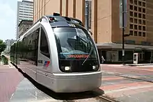
Metro currently operates three light rail lines: the Red Line, Purple Line and Green Line. The Red Line, the Authority's first light rail line, began operation on January 1, 2004. Now extended to 12.8 miles, the line begins at the Northline Transit Center, serving HCC Northeast and Northline Commons mall, and then continues south through Houston's Central Business District, Midtown, the Museum District, Rice University, the Texas Medical Center and the NRG Park Complex to the Fannin South Transit Center [31] It is the second major light rail service in Texas following the DART system. The arrival of Metro light rail comes approximately sixty years after the previous streetcar system was shut down, which left Houston as the largest city in the United States without a rail system since 1990, when Los Angeles' Blue Line opened.
Metro opened two additional light rail lines in 2015, the Purple (Southeast) and Green (East End) Lines. Destinations served by these new lines include Texas Southern University, the University of Houston, PNC Stadium, and the Theater District. These new lines added another 9.9 miles of light rail. In total, Metro operates 22.7 miles of light rail service. Metro will reach approximately 18.6 million light rail boardings in FY17.[31]
Two other lines were to be completed by 2012, but funding issues dropped the number to the northern extension of the Red Line and two of the original four new lines.[34][35] The extension of the Red Line was opened on December 21, 2013[36] and the East End/Green Line opened on May 23, 2015.[37] Due to federal investigations and the lack of funds, the plans may degenerate further.[38] Three of the five lines were previously going to be bus-rapid transit, but due to high ridership possibilities, the decision was made to make them all light rail.
Expansion
METRO Solutions
METRO Solutions was a regional transit plan approved by voters in November 2003 by a 52–48 vote.[39][40] The plan proposed:
- 64.8 miles (104 km) of Light Rail Transit
- 8 miles (13 km) of Commuter Rail Transit (CRT)
- 9 New Transit Centers
- 9 New Park & Rides Lots
- 250 miles of two-way HOV lanes
In June 2005, METRO announced a revised plan for expansion of the METRORail system. The plan included one new light rail corridor and three bus rapid transit corridors. The bus rapid transit lines would have later been converted into light rail when ridership warranted the conversion.
On October 18, 2007, the plan was revised to allow for the possibility of more federal funding. METRO decided to have all the lines consist of light rail from the start after some public backlash to the agency turning back from its original plans of light rail corridors.[41]
By 2017, only 15 miles of light rail were completed with no commuter rail lines established.[40] 8 new transit centers, 7 new park & ride lots, and only one new two-way HOV corridor were completed as well.
METRONext
The public with a 68% vote approved the METRONext plan in November 2019.[42] The plan calls for:[43][44]
- 110 miles of Regional Express Network, including two-way HOV lanes
- 21 new or improved Park & Ride lots and Transit Centers
- 16 miles of light rail expansion
- 75 miles of a bus rapid transit network METRORapid
- 290 miles of BOOST and Signature bus service
The referendum authorized the agency to issue up to $3.5 billion in bonds to pay for the projects while the remaining $4 billion will come from federal grants and local funds.[43]
Metro Police
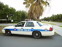
Metro operates its own police department. With over 185 Texas peace officers and 88 non-sworn, civilian employees, the department's main goal is to ensure safety and security on the transit system. The department was established in 1982 and is accredited with the Texas Police Chiefs Association (TPCA), one of only five public transit police departments in North America to be so.[45]
State law grants Metro Police jurisdiction in the counties in which Metro is located, provides services, or is supported by a general sales and use tax.[46] As peace officers, state law also grants Metro Police the power to arrest without warrant for any felony, breach of the peace, disorderly conduct or intoxication offense that is committed in their presence or view while in Texas.[47] They may also make an arrest pursuant to a warrant anywhere in Texas.[48]
Headquarters
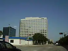
The Metro headquarters are in the Lee P. Brown Administration Building in Downtown Houston.[49] The $41 million 14 story glass and steel building has over 400,000 square feet (37,000 m2) of space. The facility includes the Downtown Transit Center, a Metro Ride store, a Houston Police Department storefront and toilets for transiting passengers.[50] The building was designed by Pierce Goodwin Alexander & Linville.[51] As of August 2010, two floors of the building are not occupied and are not used in any way.[52]
The building was scheduled to open in early 2004, coinciding with the beginning of the METRORail. The groundbreaking was held in 2002. Patti Muck, a spokesperson for METRO, said that the agency would save $273 million, assuming that the agency occupied the building for a 30-year span instead of renting for the same length of time.[50] The Federal Transit Administration,[51] a part of the federal government of the United States, paid 80% of the construction costs,[50] while Metro paid the other 20%.[51]
The “Houston in Harmony” mural[53] l in honor of Mayor Lee P Brown was commissioned by the Honey Brown Hope Foundation and its founder, Tammie Lang Campbell, in 1999. It was moved March 23, 2005, to the Lee P. Brown Metropolitan Transit Authority Administration Building, where it is on permanent display.
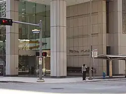
Previously the Metro headquarters were in the Louisiana Place (now the Total Plaza[54]), also in Downtown Houston.[55][56] The agency occupied 10 floors in the building and did not receive any federal funds to cover the $3.8 million annual rent.[50] The Metro Board Room was located on the 16th floor.[57] Total Petrochemicals USA, a subsidiary of TotalEnergies, moved into the space that was previously occupied by METRO; the agency scheduled its move into the Brown building to occur in January 2005.[58] Metro's lease of 193,000 square feet (17,900 m2) of space expired in April 2005.[51]
Ridership and demographics
A Regional Fixed Route Transit Rider survey sponsored by the Houston-Galveston Area Council (H-GAC), in partnership with METRO, was completed in 2017. Over 22,000 riders were surveyed—the most expansive ever conducted on a regional basis—and included eight regional fixed-route transit agencies which operate in H-GAC's eight-county region.[59] The survey found that 58 percent of riders use transit to get to work, 20 percent use it for shopping or personal business, and about 10 percent of riders use a bus or train to get to school. 88 percent of riders reported that they rode transit at least three days per week with almost 50 percent of riders riding at least five days per week. The survey's findings concluded that 88 percent of all the trips were directly contributing to the region's economy.[60]
Member cities
The Metro member cities include:[49]
Core city
Other cities
- Bellaire
- Bunker Hill Village
- Conroe
- El Lago
- Hedwig Village
- Hilshire Village
- Humble
- Hunters Creek Village
- Katy
- Missouri City
- Piney Point Village
- Spring Valley Village
- Southside Place
- Taylor Lake Village
- West University Place
In addition the agency serves many unincorporated areas.[49]
References
- "Transit Ridership Report Fourth Quarter 2023" (PDF). American Public Transportation Association. March 4, 2024. Retrieved March 14, 2024.
- "Transit Ridership Report Fourth Quarter 2023" (PDF). American Public Transportation Association. March 4, 2024. Retrieved March 14, 2024.
- "About METRO". METRO. Retrieved December 20, 2017.
- Chronology of Metro's attempts to develop a rail system Archived October 19, 2012, at the Wayback Machine FRI March 29, 1991 Houston Chronicle, Section A, Page 24, 2 STAR Edition
- "Archived copy" (PDF). Archived from the original (PDF) on February 15, 2010. Retrieved October 10, 2009.
{{cite web}}: CS1 maint: archived copy as title (link) - Ryan, Molly (February 24, 2014). "Houston Metro officially names new CEO". Houston Business Journal. American City Business Journals. Retrieved September 25, 2019.
- Turner, Allan (February 1, 2014). "Metro CEO lauded for low-key management style". Houston Chronicle. Hearst. Retrieved September 25, 2019.
- Engel, Currie (July 23, 2020). "On the 30th anniversary of the Americans with Disabilities Act, Houston looks forward". Houston Chronicle. Retrieved July 31, 2020.
[...]1978[...]It took Houston another 13 years to get accessible buses,[...]
- Yglesias, Matthew (February 18, 2015). "Houston just dramatically improved its mass transit system without spending a dime". Vox. Retrieved June 8, 2015.
- "NewBusNetwork". www.ridemetro.org. Archived from the original on January 20, 2016. Retrieved January 18, 2016.
- Begley, Dug (April 6, 2020). "Pandemic forces shutdown of downtown shuttle, maybe for good". Houston Chronicle. Retrieved June 19, 2023.
- "Executive Summary - September 2023". Houston METRO. Retrieved October 21, 2023.
- "2 Bellaire". METRO.
- "202 Kuykendahl". METRO.
- "204 Spring". METRO.
- "209 Spring / Kuykendahl". METRO.
- "212 Seton Lake". METRO.
- "216 West Little York / Northwest Station". METRO.
- "217 Cypress". METRO.
- "219 Cypress / Northwest Station / West Little York". METRO.
- "314 Hiram Clarke". METRO.
- "344 Acres Homes". METRO.
- "363 Missouri City". METRO.
- "377 Kashmere Late Night". METRO.
- "Accessing METRO by Car". Retrieved October 21, 2017.
- Connelly, Richard. "Metro: No Ads On Buses, Despite (Or Because Of) Tough Economic Times Archived 2010-07-23 at the Wayback Machine." Houston Press. Tuesday July 20, 2010. Retrieved on August 10, 2010.
- Fare increases an option as Metro looks at rail funding – Houston Chronicle. Chron.com (July 21, 2010). Retrieved on 2013-08-15.
- Metro breaks tradition with Zoo ads featured on trains | khou.com Houston Archived October 18, 2015, at the Wayback Machine. Khou.com (August 6, 2010). Retrieved on 2013-08-15.
- Day pass returning for Metro riders – Houston Chronicle. Chron.com (March 28, 2013). Retrieved on 2013-08-15.
- "Metro Lift Archived 2008-05-15 at the Wayback Machine." Metropolitan Transit Authority of Harris County, Texas.
- "Archived copy" (PDF). Archived from the original (PDF) on July 7, 2018. Retrieved July 6, 2018.
{{cite web}}: CS1 maint: archived copy as title (link) - "METRORail riding sets record – Houston Business Journal". Archived from the original on June 14, 2008.
- "MetroRail notches record number of riders for Astros' victory parade, celebration". November 6, 2017.
- Houston Mayor Annise Parker wants to put brakes on University and Uptown rail lines | abc13.com Archived January 8, 2014, at the Wayback Machine. Abclocal.go.com (March 11, 2010). Retrieved on 2013-08-15.
- Rick Casey: Metro can't let rail jeopardize its buses – Houston Chronicle. Chron.com (March 11, 2010). Retrieved on 2013-08-15.
- Rail puts Fulton Corridor on the verge of a boom – Houston Chronicle. Chron.com (May 31, 2010). Retrieved on 2013-08-15.
- Metro's East End Light Rail Corridor construction project reaches major milestone | abc13.com Archived October 5, 2012, at the Wayback Machine. Abclocal.go.com (April 16, 2010). Retrieved on 2013-08-15.
- Metro cancels real estate contract, then rehires firm – Houston Chronicle. Chron.com (July 23, 2010). Retrieved on 2013-08-15.
- BABINECK, MARK (November 5, 2003). "Houston presses ahead with rail plan". Chron. Retrieved June 19, 2023.
- "METRONext: About METRONext". naboo.langranddev.com. Retrieved June 19, 2023.
- Sallee, Rad. "Metro Will Use Light Rail for 5 Future Lines / Board nixes less popular bus rapid transit and picks route on Richmond Archived 2012-10-22 at the Wayback Machine." Houston Chronicle. Friday October 19, 2007. A1. Retrieved on May 24, 2009.
- Begley, Dug (November 7, 2019). "Houston transit officials savor win, start work on $3.5B plan for buses and trains". Houston Chronicle. Retrieved June 19, 2023.
- "METRONext Moving Forward Plan | ADA Accessible Public Transit | Houston, Texas". Ride Metro. Retrieved June 19, 2023.
- "Resolution No. 2019-71 Calling a Special Election to be Held on Tuesday, November 5, 2019". Houston METRO. Retrieved June 19, 2023.
- "METRO Police".
- "Transportation Code Chapter 451. Metropolitan Rapid Transit Authorities". state.tx.us.
- "Code of Criminal Procedure Chapter 14. Arrest Without Warrant". state.tx.us.
- "Code of Criminal Procedure Chapter 15. Arrest Under Warrant". state.tx.us.
- "A Comprehensive Look at the Metropolitan Transit Authority of Harris County, Houston, Texas Archived May 24, 2009, at the Wayback Machine." Metropolitan Transit Authority of Harris County, Texas. Retrieved on April 5, 2010. "Headquarters Lee P. Brown Metro Administration Building 1900 Main St. Houston, Texas 77002"
- Sallee, Rad. "Metro touting future savings from building Archived 2012-10-18 at the Wayback Machine." Houston Chronicle. Wednesday August 21, 2002. A25. Retrieved on April 5, 2010.
- Sarnoff, Nancy. "Metro gets rolling on downtown transit center." Houston Business Journal. Friday January 4, 2002. Retrieved on April 5, 2010.
- Knight, Paul. "George Greanias Lays The Groundwork For Metro's Tough Upcoming Budget Decisions Archived 2012-04-02 at the Wayback Machine." Houston Press. Tuesday August 31, 2010. Retrieved on August 31, 2010.
- "Fort Bend group lauds former Houston mayor for public service". Houston Chronicle. March 31, 2005.
- "Total Plaza Archived 2009-04-24 at the Wayback Machine." Brookfield Properties. Retrieved on April 5, 2010.
- "Contacting METRO." Metropolitan Transit Authority of Harris County, Texas. March 4, 2001. Retrieved on April 5, 2010.
- Dawson, Jennifer. "Hilcorp increases downtown presence." Houston Business Journal. Thursday June 22, 2006. Retrieved on April 5, 2010.
- Sallee, Rad. "Metro digs up $65 million for rail / Project to go without federal funds Archived 2012-10-18 at the Wayback Machine." Houston Chronicle. Wednesday October 25, 2000. A1. Retrieved on April 5, 2010.
- Dawson, Jennifer. "ATOFINA to move from Greenspoint to downtown." Houston Business Journal. Monday July 19, 2004. Retrieved on April 5, 2010.
- "Capital and Strategic Planning Committee MTG".
- Delaughter, Gail (June 20, 2018). "A New Study Looks At Who's Using Public Transit In The Houston Area". Houston Public Media. University of Houston. Retrieved September 25, 2019.
Further reading
- Spivak, Todd. "Run Over by Metro." Houston Press. March 3, 2006.
External links
- Metro Official Page
- Metro Official Page at the Wayback Machine (archive index)
| Bus service |
| |
|---|---|---|
| METRORapid lines |
| |
| METRORail lines |
| |
| Related articles |
| |