James Ross Island
James Ross Island is a large island off the southeast side and near the northeastern extremity of the Antarctic Peninsula, from which it is separated by Prince Gustav Channel. Rising to 1,630 metres (5,350 ft), it is irregularly shaped and extends 64 km (40 miles) in a north–south direction. It was charted in October 1903 by the Swedish Antarctic Expedition under Otto Nordenskiöld, who named it for Sir James Clark Ross, the leader of a British expedition to this area in 1842 that discovered and roughly charted a number of points along the eastern side of the island. The style, "James" Ross Island is used to avoid confusion with the more widely known Ross Island in McMurdo Sound.[1]
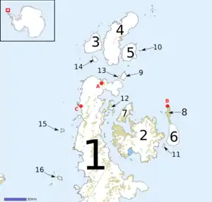 Map of Graham Land, showing James Ross Island (2) | |
 James Ross James Ross Island (Antarctic Peninsula) | |
| Geography | |
|---|---|
| Location | Antarctica |
| Coordinates | 64°10′S 57°45′W |
| Archipelago | James Ross Island group |
| Area | 2,598 km2 (1,003 sq mi) |
| Length | 64 km (39.8 mi) |
| Highest elevation | 1,630 m (5350 ft) |
| Highest point | Mount Haddington |
| Administration | |
| Administered under the Antarctic Treaty System | |
It is one of several islands around the peninsula known as Graham Land, which is closer to South America than any other part of that continent.[2]
The island was connected to the Antarctic mainland by an ice shelf until 1995, when the ice shelf collapsed, making the Prince Gustav Channel passable for the first time.[3]
Mendel Polar Station, the first Czech Antarctic Base, is located on the island.
Paleontology
Two dinosaur-bearing formations are present on the island, both from the Upper Cretaceous: the Santa Marta Formation and the Snow Hill Island Formation. These are two of only three known formations to have dinosaur fossils in Antarctica.
The first dinosaur discovered in Antarctica was Antarctopelta oliveroi, a medium-sized ankylosaur found on James Ross Island by Argentinian geologists Eduardo Olivero and Roberto Scasso in 1986. The dinosaur was recovered from the Campanian stage of the Upper Cretaceous Santa Marta Formation, about 2 km (1.2 mi) south of Santa Marta Cove on the north part of the island. The ankylosaur was not formally named until 2006.[4]

In December 2003, U.S. paleontologist Judd Case from Saint Mary's College of California and U.S. geologist James Martin from the South Dakota School of Mines & Technology discovered the bones of a theropod dinosaur on the island. Nicknamed "Naze" after the northerly Naze Peninsula on which it was found, the Late Cretaceous remains include an upper jaw and teeth, and most of the lower legs and feet. Little information is available, but the shape of the leg and feet indicate it was a runner. In 2019, it was given the name Imperobator antarcticus. It was large, about the size of Utahraptor. It is the second Antarctic theropod discovered, after Cryolophosaurus.[5]
An ornithopod was found in the Snow Hill Island Formation by Argentine paleontologists Rodolfo Aníbal Coria and Juan José Moly in 2008. In 2013, Coria named it Trinisaura santamartaensis.[6]
In 2015, an iguanodontid found in 2002 by Fernando Novas[7] was named Morrosaurus antarcticus by Sebastian Rozadilla, Federico Lisandro Agnolin, Fernando Emilio Novas, Alexis Rolando Aranciaga Mauro, Matthew J. Motta, Juan Manuel Lirio Marcelo and Pablo Isasi. The genus name refers to the site of El Morro on James Ross Island, where the remains of the species were found. The specific name refers to Antarctica.[8]
Notable features
Notable features, clockwise from the west, include:
- Ulu Peninsula (63°56′S 58°5′W) is that portion of James Ross Island northwest of the narrow neck of land between Rohss Bay and Croft Bay, extending from Cape Obelisk to Cape Lachman.[9]
- Croft Bay (64°0′S 57°45′W) is a bay which indents the north-central side of James Ross Island and forms the southern part of Herbert Sound.[10]
- Markham Bay (64°17′S 57°18′W) is a bay 8 nautical miles (15 km; 9.2 mi) wide, lying between Ekelöf Point and Hamilton Point on the east side of James Ross Island.[11]
- Röhss Bay (64°12′S 58°16′W) is a bay 11 nautical miles (20 km; 13 mi) wide, between Cape Broms and Cape Obelisk on the southwest side of James Ross Island.[12]
Other features
- Cape Foster 64°27′S 57°59′W
- Cape Gage 64°10′S 57°5′W
- Carlsson Bay 64°24′S 58°4′W
- Coley Glacier 64°9′S 57°14′W
- Crame Col 63°49′S 57°53′W
- Dagger Peak 63°55′S 57°29′W
- Flett Buttress 64°7′S 57°49′W
- Förster Cliffs 64°1′S 57°33′W
- Howarth Glacier 64°23′S 57°23′W
- Hurst Bay 63°57′S 57°28′W
- Jefford Point 64°24′S 57°41′W
- Lomas Ridge 64°22′S 57°35′W
- Lonely Rock 64°6′S 57°3′W
- Massey Heights 63°58′S 57°58′W
- Mount Haddington 64°13′S 57°38′W
- Nygren Point 64°23′S 58°13′W
- San José Pass 63°55′S 57°54′W
- Seacatch Nunataks 63°58′S 58°4′W
- Skep Point 64°3′S 57°18′W
- Sungold Hill 64°23′S 57°52′W
- Swift Bay 64°22′30″S 57°46′13″W
- Swift Glacier 64°22′S 57°46′W
- Tait Glacier 64°22′S 58°2′W
- Terrapin Hill 63°58′S 57°32′W
- Tortoise Hill 64°22′S 57°30′W
- Ula Point 64°5′S 57°9′W
- Virgin Hill 63°56′S 58°9′W
See also
- Blancmange Hill
- Composite Antarctic Gazetteer
- List of Antarctic islands south of 60° S
- Nygren Point
- Scientific Committee on Antarctic Research
- Skep Point
- Territorial claims in Antarctica
- Whisky Bay
References
- "James Ross Island". Geographic Names Information System. United States Geological Survey, United States Department of the Interior. Retrieved 16 July 2012.
- ESA Science & Technology: Graham Land
- Rubin, Jeff (2008). Antarctica, p. 276. Lonely Planet.
- Salgado, L.; Gasparini, Z. (2006). "Reappraisal of an ankylosaurian dinosaur from the Upper Cretaceous of James Ross Island (Antarctica)". Geodiversitas. 28 (1): 119–135.
- "A Lost World: Two Previously Unknown Dinosaurs Discovered in Antarctica". Maryland VIP K-16 Grant. Science Inquiry. Archived from the original on 29 September 2007. Retrieved 4 April 2007.
- Coria, R. A.; Moly, J. J.; Reguero, M.; Santillana, S.; Marenssi, S. (2013). "A new ornithopod (Dinosauria; Ornithischia) from Antarctica". Cretaceous Research. 41: 186–193. doi:10.1016/j.cretres.2012.12.004. hdl:11336/76749.
- Novas, F.E., A.V. Cambiaso, J. Lirio, & H. Núñez, 2002, "Paleobiogeografía de los dinosaurios cretácicos polares de Gondwana", Ameghiniana (Resúmenes) 39(4): 15R
- Rozadilla, Sebastián; Agnolin, Federico L.; Novas, Fernando E.; Aranciaga Rolando, Alexis M.; Motta, Matías J.; Lirio, Juan M.; Isasi, Marcelo P. (2016). "A new ornithopod (Dinosauria, Ornithischia) from the Upper Cretaceous of Antarctica and its palaeobiogeographical implications". Cretaceous Research. 57: 311–324. doi:10.1016/j.cretres.2015.09.009.
- Alberts 1995, p. 769.
- Alberts 1995, p. 162.
- Alberts 1995, p. 462.
- Alberts 1995, p. 627.
![]() This article incorporates public domain material from "James Ross Island". Geographic Names Information System. United States Geological Survey.
This article incorporates public domain material from "James Ross Island". Geographic Names Information System. United States Geological Survey.