Makwanpur District
Makwanpur District(Nepali: मकवानपुर जिल्ला; ⓘ, in Bagmati Province, earlier a part of Narayani Zone, is one of the seventy-seven districts of Nepal. The city of Hetauda serves as the district headquarters and also as the provincial headquarters. The district covers an area of 2,426 km2 (937 sq mi) and had a population of 392,604 in 2001 and 420,477 in 2011.[2] The latest census of 2021 recorded the population of Makwanpur as 466,073.[3]
Makwanpur District
मकवानपुर | |
|---|---|
 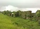 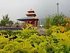 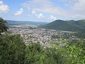 Kulekhani Reservoir, Kushmanda Sarowar Triveni Dham, Hetauda city (Headquarter), Remains of Makwanpur fort (Clockwise from top) | |
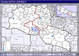
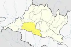 Location of district in province | |
| Country | |
| Province | Bagmati Province |
| Admin HQ. | Hetauda |
| Government | |
| • Type | Coordination committee |
| • Body | DCC, Makawanpur |
| Area | |
| • Total | 2,426 km2 (937 sq mi) |
| Population (2011)[1] | |
| • Total | 420,477 |
| • Density | 170/km2 (450/sq mi) |
| Time zone | UTC+05:45 (NPT) |
| Main Language(s) | Nepali |
| Website | www.ddcmakwanpur.gov.np |
History
During Rana regime, the district was named Chisapani District and the headquarter of the district was situated in Chisapanigadhi. The district renamed as Makwanpur on the name of Makwanpurgadhi and the headquarter moved to Hetauda in 1982.
Geography and climate
| Climate Zone[4] | Elevation Range | % of Area |
|---|---|---|
| Lower Tropical | below 300 meters (1,000 ft) | 7.2% |
| Upper Tropical | 300 to 1,000 meters 1,000 to 3,300 ft. |
59.0% |
| Subtropical | 1,000 to 2,000 meters 3,300 to 6,600 ft. |
28.9% |
| Temperate | 2,000 to 3,000 meters 6,400 to 9,800 ft. |
4.9% |
Demographics
| Census year | Pop. | ±% p.a. |
|---|---|---|
| 1981 | 243,411 | — |
| 1991 | 314,599 | +2.60% |
| 2001 | 392,604 | +2.24% |
| 2011 | 420,477 | +0.69% |
| 2021 | 461,053 | +0.93% |
| Source: Citypopulation[5] | ||
At the time of the 2011 Nepal census, Makwanpur District had a population of 420,477.
As their first language, 45.8% spoke Tamang, 41.5% Nepali, 4.1% Newari, 3.9% Chepang, 1.4% Magar, 0.9% Bhojpuri, 0.6% Maithili, 0.5% Rai, 0.2% Gurung, 0.2% Lepcha, 0.2% Majhi, 0.1% Hindi, 0.1% Pahari, 0.1% Tharu, 0.1% Urdu and 0.2% other languages.[6]
Ethnicity/caste: 48.3% were Tamang, 14.1% Hill Brahmin, 10.5% Chhetri, 6.2% Newar, 4.6% Chepang/Praja, 4.5% Magar, 2.9% Kami, 1.9% Rai, 0.8% Damai/Dholi, 0.8% Majhi, 0.7% Gurung, 0.4% Musalman, 0.4% Thakuri, 0.3% Danuwar, 0.3% Kathabaniyan, 0.3% Pahari, 0.3% Sanyasi/Dasnami, 0.3% Sarki, 0.2% Gharti/Bhujel, 0.2% Tharu, 0.1% Terai Brahmin, 0.1% other Dalit, 0.1% Ghale, 0.1% Hajam/Thakur, 0.1% Kalwar, 0.1% Kanu, 0.1% Limbu, 0.1% Marwadi, 0.1% Sunuwar, 0.1% Teli, 0.1% other Terai, 0.1% Yadav and 0.2% others.[7]
Religion: 48.3% were Hindu, 45.6% Buddhist, 4.8% Christian, 0.7% Prakriti, 0.4% Muslim and 0.2% others.[8]
Literacy: 67.5% could read and write, 2.7% could only read and 29.8% could neither read nor write.[9]
Administration
The district consists of 10 Municipalities, out of which one is a sub-metropolitan city, one is an urban municipality and eight are rural municipalities. These are as follows:[10]
- Hetauda Sub-Metropolitan City
- Thaha Municipality
- Bhimphedi Rural Municipality
- Makawanpurgadhi Rural Municipality
- Manahari Rural Municipality
- Raksirang Rural Municipality
- Bakaiya Rural Municipality
- Bagmati Rural Municipality
- Kailash Rural Municipality
- Indrasarowar Rural Municipality
Former Village Development Committees and Municipalities
- Agara
- Ambhanjyang
- Bajrabarahi
- Betini
- Bhainse
- Bharta Pundyadevi
- Bhimphedi
- Budhichaur
- Chhatiwan
- Chitlang
- Dandakharka
- Dhimal
- Gogane
- Handikhola
- Hetauda (Sub metropolitan city)
- Hurnamadi
- Ipa Panchakanya
- Kalikatar
- Kankada
- Khairang
- Kogate
- Kulekhani
- Makwanpurgadhi
- Manahari
- Manthali
- Markhu
- Marta Punchedevi
- Namtar
- Nibuwatar
- Fakhel
- Phaparbari
- Raigaun
- Raksirang
- Sarikhet Palase
- Shikharpur
- Sripur Chhatiwan
- Sisneri Mahadevsthan
- Sukaura
- Thaha Municipality
- Thingan
- Tistung Deurali
Notable people
- Tilak Bahadur Negi Lamaतिलक बहादुर नेगी - Nepalese politician, first minister of Makwanpur District and nepalese Tamang people/Communities in June 16 1981 (२०३८ असार २ गते).[11]
- Rupchandra Bista - Nepalese politician
- Kamal Thapa - Nepalese politician
- Ganesh Thapa - ex. president of the All Nepal Football Association
- Kabiraj Negi Lama - Nepalese National Para Taekwondo Team Coach and 2020 Summer Paralympics Coach
- Ananta Prasad Paudel - Nepalese politician
- Ganesh Lal Shrestha - Nepalese poet, musician and social worker
- Bal Krishna Pokharel - Nepalese writer, linguist, historian, and literary critic
- Kedar Ghimire - Nepalese comedian, actor, scriptwriter, and film producer
- Ajeya Sumargi - chairman of the Muktishree group of companies
- Anjan Bista - Nepali footballer
- Bikash Bista - Nepalese Economist and Statistician, and the former Director General of Central Bureau of Statistics of Nepal
- Birodh Khatiwada - Nepalese politician
- Indra Bahdur Baniya - Nepalese politician
- Girija Prasad Adhikari
- Prabesh Rijal
- Dipak Bahadur Singh
- Rajan Mainali
- Shrinkhala Khatiwada - Nepalese model and Miss Nepal World 2018
- Sunil Bal - Nepalese footballer
- Shrijana Ghising - Nepalese Para Taekwondo practitioner
References
- General Bureau of Statistics, Kathmandu, Nepal, Nov. 2012
- "Census Nepal 2021". censusnepal.cbs.gov.np. Retrieved 2024-03-05.
- "population | national_population and housing_census_year results". censusnepal.cbs.gov.np. Retrieved 2024-03-05.
- The Map of Potential Vegetation of Nepal - a forestry/agroecological/biodiversity classification system (PDF), Forest & Landscape Development and Environment Series 2-2005 and CFC-TIS Document Series No.110., 2005, ISBN 87-7903-210-9, retrieved Nov 22, 2013
- "NEPAL: Administrative Division". www.citypopulation.de.
- NepalMap Language
- NepalMap Caste
- NepalMap Religion
- NepalMap Literacy
- "स्थानिय तह" (in Nepali). Ministry of Federal Affairs and General Administration. Archived from the original on 31 August 2018. Retrieved 1 September 2018.
- "सोनाम ल्होछारको अवसरमा तामाङ समुदायका पहिलो मन्त्री सम्मानित".
- "Districts of Nepal". Statoids.
Headquarters: Hetauda | ||
| Sub-metropolitan cities | | |
| Municipalities |
| |
| Rural municipalities |
| |