Northern District (Israel)
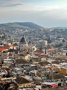
The Northern District (Hebrew: מחוז הצפון, Mekhoz HaTzafon; Arabic: منطقة الشمال, Minṭaqat ash-Shamāl) is one of Israel's six administrative districts. The Northern District has a land area of 3,324 km2, making it the second largest district in Israel. The district capital is Nof HaGalil and the largest city is Nazareth.
Northern District | |
|---|---|
| - transcription(s) | |
| • Arabic | منطقة الشمال Minṭaqat ash-Shamāl |
| • Hebrew | מחוז הצפון Mekhoz HaTzafon |
.svg.png.webp) | |
| Cities | 18 |
| Local Councils | 60 |
| Regional Councils | 15 |
| Capital | Nof HaGalil |
| Largest | Nazareth |
| Government | |
| • District Commissioner[1] | Uri Ilan (acting)[2] |
| Area | |
| • Total | 3,324 km2 (1,283 sq mi) |
| Population (2023)[3] | |
| • Total | 1,527,800 |
| • Density | 460/km2 (1,200/sq mi) |
| ISO 3166 code | IL-Z |
The Golan Heights has been run as a sub-district of the North District of Israel since the 1981 Golan Heights Law was passed, although the claim is only recognized by the United States[4] while United Nations Security Council condemned the annexation in its Resolution 497 without enforcing it. The Golan Heights covers a land area of 1,154 km2 and the remainder of the Northern District covers 3,324 km2 (3,484 km2 including water).
Demographics
According to the Israeli Central Bureau of Statistics data for 2022:[5]
- Total population: 1,527,800 (2022)
- Ethnic:
In the Israeli census, no distinction is made between Arab citizens of Israel and Syrian inhabitants of the Golan Heights, many of whom are not citizens of Israel, but of Syria.
- Religious:
- Jews: 647,500 (42.4%)
- Muslims: 597,300 (39.1%)
- Druze: 120,300 (7.9%)
- Christians: 97,800 (6.4%)
- Not classified: 55,600 (3.6%)
- Density: 335/km2
The Northern District is the only district of Israel where the majority of inhabitants are Arabs.
Administrative local authorities


| Subdistricts | ||
|---|---|---|
| ||
| Cities | Local Councils | Regional Councils |
|
| |
References
- Transfer of Power (District Commissioners and District Officers) Law, 5724-1964, Laws of the State of Israel vol. 18 no 38. (pp. 70-71)
- "בעלי תפקידים במשרד הפנים".
- "Localities by Population, by District, Sub-District and Type of Locality". Israel Central Bureau of Statistics.
- Romo, Vanessa (25 March 2019). "Trump Formally Recognizes Israeli Sovereignty Over Golan Heights". NPR.
- "Population, by Population Group, Religion, Age and Sex, District and Sub-District" (PDF). Israel Central Bureau of Statistics. 2023. Archived (PDF) from the original on March 11, 2023. Retrieved March 11, 2023.
- Population in localities and statistical areas, by religion, end of 2019
Places adjacent to Northern District (Israel) | |
|---|---|
| Cities | | ||||
|---|---|---|---|---|---|
| Local councils |
| ||||
| Regional councils |
| ||||