Ogōri, Fukuoka
Ogōri (小郡市, Ogōri-shi) is a city located in Fukuoka Prefecture, Japan.[1] As of 1 February 2024, the city had an estimated population of 59,590 in 25998 households, and a population density of 1309 persons per km².[2] The total area of the city is 45.51 km2 (17.57 sq mi).
Ogōri
小郡市 | |
|---|---|
 Kyushu Historical Museum | |
 Flag  Seal | |
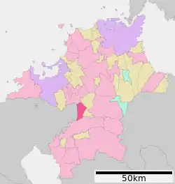
Location of Ogōri in Fukuoka Prefecture | |
 | |
 Ogōri Location in Japan | |
| Coordinates: 33°23′47″N 130°33′20″E | |
| Country | Japan |
| Region | Kyushu |
| Prefecture | Fukuoka |
| Government | |
| • Mayor | Yoshimizu Kaji (since May 2017) |
| Area | |
| • Total | 45.51 km2 (17.57 sq mi) |
| Population (February 1, 2023) | |
| • Total | 59,590 |
| • Density | 1,300/km2 (3,400/sq mi) |
| Time zone | UTC+09:00 (JST) |
| City hall address | 255-1 Ogōri, Ogōri-shi, Fukuoka-ken 838-0198 |
| Website | Official website |
| Symbols | |
| Bird | Heron |
| Flower | Wisteria floribunda |
| Tree | Cinnamomum camphora |

Geography
Ogōri is located in southern Fukuoka Prefecture. The city is long and narrow from north-to-south. The Homan River, a tributary of the Chikugo River water system, runs through the city from north-to-south.
Climate
Ogōri has a humid subtropical climate (Köppen Cfa) characterized by warm summers and cool winters with light to no snowfall. The average annual temperature in Ogōri is 15.2 °C. The average annual rainfall is 1766 mm with September as the wettest month.[3]
Demographics
Per Japanese census data, the population of Ogōri is as shown below
| Year | Pop. | ±% |
|---|---|---|
| 1940 | 16,549 | — |
| 1950 | 22,216 | +34.2% |
| 1960 | 24,642 | +10.9% |
| 1970 | 30,469 | +23.6% |
| 1980 | 41,057 | +34.8% |
| 1990 | 47,116 | +14.8% |
| 2000 | 54,583 | +15.8% |
| 2010 | 58,499 | +7.2% |
| 2020 | 59,578 | +1.8% |
History
The area of Ogōri was part of ancient Chikugo Province. During the Edo Period the area was under the control of Kurume Domain. After the Meiji restoration, the village of Ogōri was established on May 1, 1889 with the creation of the modern municipalities system. Ogōri was raised to town status on October 1, 1953. It annexed the neighboring villages of Mikuni, Tateishi, Mihara, and Ajisaka on March 31, 1955 and was raised to city status on April 1, 1972 .
Government
Ogōri has a mayor-council form of government with a directly elected mayor and a unicameral city council of 18 members. Ogōri, together with the town of Tachiarai, contributes two members to the Fukuoka Prefectural Assembly. In terms of national politics, the city is part of the Fukuoka 6th district of the lower house of the Diet of Japan.
Economy
Ogōri has a mixed economy centering on agriculture and light manufacturing. A large percentage of the working population commutes to nearby Kurume or to Fukuoka City for work.
Education
Ogōri has eight public elementary schools and five public junior high schools operated by the city government and two public high schools operated by the Fukuoka Prefectural Board of Education. There is also one private junior high school. The prefecture also operates a special education school for the handicapped.
Transportation
Railways
![]() Nishitetsu Tenjin Ōmuta Line
Nishitetsu Tenjin Ōmuta Line
- Tsuko - Mikunigaoka - Mitsusawa - Ōho - Nishitetsu Ogōri - Hatama - Ajisaka
■ Amagi Railway Amagi Line
- Ogōri - Ōitai - Matsuzaki - Imaguma
Highways
 Kyushu Expressway
 Ōita Expressway
 National Route 500
Local attractions
- Kyushu Historical Museum
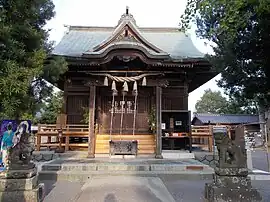
- Tanabata Shrine
- Nyōirin Temple, also known as temple of the frog
- Ogōri Kanga ruins, National Historic Site
Notable residents of Ogōri
- Maki Itoh - professional wrestler, idol
- Misa Eguchi - tennis player[4]
- Masahiro Nakatani - baseball player
- Hikaru Naomoto - footballer
- Kazuyuki Hoashi - baseball player
References
- "小郡市 | 4地域と60市町村紹介|福岡県ってどんなところ?|福岡県 移住・定住ポータルサイト 福がお~かくらし". 福岡県 移住・定住ポータルサイト 福がお~かくらし (in Japanese). Retrieved 2022-10-22.
- "Ogōri City official statistics" (in Japanese). Japan.
- Ogōri climate: Average Temperature, weather by month
- "プレーヤー:江口 実沙 - 日本テニス協会公式サイト". 2014-10-11. Archived from the original on 2014-10-11. Retrieved 2022-10-22.
External links
- Ogōri City official website (in Japanese)
| Fukuoka |
| |||
|---|---|---|---|---|
| Kitakyushu |
| |||
| Core city | ||||
| Cities | ||||
| Districts | ||||
List of mergers in Fukuoka Prefecture | ||||