San Agustín, Huila
San Agustín (Spanish pronunciation: [san aɣusˈtin]) is a town and municipality in the southern Colombian Department of Huila. The town is located 227 km away from the capital of the Department, Neiva. Population is around 34,000.[1] The village was founded in 1752 by Alejo Astudillo but attacks by indigenous people destroyed it. The present village was founded in 1790 by Lucas de Herazo y Mendigaña.
San Agustín, Huila | |
|---|---|
Municipality and town | |
_Village.JPG.webp) | |
.svg.png.webp) Flag | |
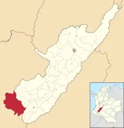 Location of the municipality and town of San Agustín, Córdoba in the Huila Department of Colombia. | |
| Country | |
| Department | Huila Department |
| Population (2020 est.[1]) | |
| • Total | 34,420 |
| Time zone | UTC-5 (Colombia Standard Time) |
The mean temperature year round is 18 °C.
Climate
San Agustín has a subtropical highland climate (Köppen: Cfb)[2] with warm temperatures and frequent rainfall.
| Climate data for San Agustín Archaeological Park (1991–2020) | |||||||||||||
|---|---|---|---|---|---|---|---|---|---|---|---|---|---|
| Month | Jan | Feb | Mar | Apr | May | Jun | Jul | Aug | Sep | Oct | Nov | Dec | Year |
| Mean daily maximum °C (°F) | 24.58 (76.24) |
24.6 (76.3) |
23.99 (75.18) |
23.86 (74.95) |
23.33 (73.99) |
22.27 (72.09) |
21.53 (70.75) |
22.16 (71.89) |
23.52 (74.34) |
24.24 (75.63) |
24.23 (75.61) |
24.36 (75.85) |
23.56 (74.41) |
| Daily mean °C (°F) | 19.2 (66.6) |
19.31 (66.76) |
19.05 (66.29) |
18.89 (66.00) |
18.74 (65.73) |
18.02 (64.44) |
17.53 (63.55) |
17.68 (63.82) |
18.43 (65.17) |
18.88 (65.98) |
18.94 (66.09) |
19.01 (66.22) |
18.64 (65.55) |
| Mean daily minimum °C (°F) | 13.89 (57.00) |
14.21 (57.58) |
14.38 (57.88) |
14.42 (57.96) |
14.38 (57.88) |
13.94 (57.09) |
13.39 (56.10) |
13.07 (55.53) |
13.25 (55.85) |
13.77 (56.79) |
14.12 (57.42) |
14.11 (57.40) |
13.91 (57.04) |
| Average precipitation mm (inches) | 85.98 (3.39) |
107.34 (4.23) |
128.75 (5.07) |
150.51 (5.93) |
152.93 (6.02) |
155.34 (6.12) |
144.94 (5.71) |
99.44 (3.91) |
90.87 (3.58) |
108.91 (4.29) |
141.36 (5.57) |
118.66 (4.67) |
1,485.03 (58.47) |
| Average precipitation days (≥ 1.0 mm) | 11.47 | 13.14 | 15.2 | 17.4 | 19.57 | 19.27 | 20.25 | 16.58 | 14.07 | 14.8 | 16.17 | 14.07 | 191.98 |
| Source: NOAA[3] | |||||||||||||
San Agustín Archaeological Park
The area is very well known for its pre-Columbian archaeological sites belonging to the ancient San Agustin culture. These sites comprise the San Agustín Archaeological Park, which generates significant revenue to the economy due to the high volume of tourists, both Colombian and foreigners. This site was declared a UNESCO World Heritage Site in 1995.
Gallery
 Church of San Agustín
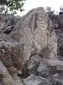 Stone carving
 Market
See also
- List of megalithic sites
External links
- Video and downloadable GPS Track of a loop hike in San Agustin to the ruins of El Tablon, La Chaquira, El Purutal, and La Pelota.
 Media related to San Agustín, Huila at Wikimedia Commons
 San Agustin travel guide from Wikivoyage
- Unesco's website on San Agustin
References
- "Resultados y proyecciones (2005-2020) del censo 2005". Retrieved 17 April 2020.
- "Table 1 Overview of the Köppen-Geiger climate classes including the defining criteria". Nature: Scientific Data. 23 October 2023.
- "World Meteorological Organization Climate Normals for 1991-2020 — San Agustín". National Oceanic and Atmospheric Administration. Retrieved January 25, 2024.
| ||
Archaeological sites in Colombia | ||
|---|---|---|
| Prehistoric-preceramic |  | |
| Preceramic-ceramic |
| |