Thomaston, Georgia
Thomaston is a city in and the county seat of Upson County,[5] Georgia, United States.[6] The population was 9,170 at the 2010 census. It is the principal city of and is included in the Thomaston, Georgia Micropolitan Statistical Area, which is included in the Atlanta - Sandy Springs (GA) - Gainesville (GA) - Alabama (partial) CSA.
City of Thomaston | |
|---|---|
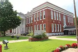 Thomaston-Upson County Government Administration Complex | |
 Flag  Seal Logo | |
| Motto: "One of the Best 100 Towns"[1] | |
 Location in Upson County and the state of Georgia. | |
| Coordinates: 32°54′N 84°20′W | |
| Country | United States |
| State | Georgia |
| County | Upson |
| Area | |
| • Total | 9.74 sq mi (25.24 km2) |
| • Land | 9.54 sq mi (24.71 km2) |
| • Water | 0.20 sq mi (0.53 km2) |
| Elevation | 784 ft (239 m) |
| Population (2020) | |
| • Total | 9,816 |
| • Density | 1,029.04/sq mi (397.32/km2) |
| Time zone | UTC-5 (Eastern (EST)) |
| • Summer (DST) | UTC-4 (EDT) |
| ZIP code | 30286 |
| Area code | 706 |
| FIPS code | 13-76168[3] |
| GNIS feature ID | 0324093[4] |
| Website | Official City of Thomaston, Georgia Government Website |
History
.JPG.webp)
Thomaston was incorporated on January 1, 1825,[7] and designated as the seat of Upson County. The town was named for General Jett Thomas, an Indian fighter in the War of 1812.[8]
Geography
Thomaston is located near the center of Upson County at 32.90 N, -84.333333 W (32° 54′ 0″ N, 84° 20′ 0″ W).[9] The city is located in the west central Piedmont region of the state.
U.S. Route 19 is the main north–south route through the city, leading north 16 mi (26 km) to Zebulon and south 28 mi (45 km) to Butler. Georgia State Routes 36 and 74 are the main east–west routes through the city. GA-36 leads northeast 17 mi (27 km) to Barnesville and southwest 18 mi (29 km) to Woodland. GA-74 leads east 12 mi (19 km) to Yatesville and northwest 19 mi (31 km) to Woodbury.
Demographics
| Census | Pop. | Note | %± |
|---|---|---|---|
| 1880 | 570 | — | |
| 1890 | 1,181 | 107.2% | |
| 1900 | 1,714 | 45.1% | |
| 1910 | 1,645 | −4.0% | |
| 1920 | 2,502 | 52.1% | |
| 1930 | 4,922 | 96.7% | |
| 1940 | 6,396 | 29.9% | |
| 1950 | 6,580 | 2.9% | |
| 1960 | 9,336 | 41.9% | |
| 1970 | 10,024 | 7.4% | |
| 1980 | 9,682 | −3.4% | |
| 1990 | 9,127 | −5.7% | |
| 2000 | 9,411 | 3.1% | |
| 2010 | 9,170 | −2.6% | |
| 2020 | 9,816 | 7.0% | |
| U.S. Decennial Census[10] 1850-1870[11] 1880[12] 1890-1910[13] 1920-1930[14] 1930-1940[15] 1940-1950[16] 1960-1980[17] 1990[18] | |||
| Race | Num. | Perc. |
|---|---|---|
| White (non-Hispanic) | 4,899 | 49.91% |
| Black or African American (non-Hispanic) | 4,202 | 42.81% |
| Native American | 21 | 0.21% |
| Asian | 34 | 0.35% |
| Pacific Islander | 1 | 0.01% |
| Other/Mixed | 357 | 3.64% |
| Hispanic or Latino | 302 | 3.08% |
As of the 2020 United States census, there were 9,816 people, 3,333 households, and 1,779 families residing in the city.
Health care
Its principal hospital is the Upson Regional Medical Center at 801 West Gordon Street.
Industry
Industry in the city is driven primarily by manufacturing which makes up 36.5%. The second largest industry is educational, health, and social service comprising 21.0%. The third largest industry is retail trade at 11.6% of the total industry in Thomaston. The remaining portions of industry include agriculture, construction, wholesale trade, transportation, information, finance, management, administration, arts and entertainment, food service, recreation, accommodation, and public administration.
Arts and culture
National Register of Historic Places
The Upson County courthouse was built in 1908, and is listed on the National Register of Historic Places.[20]
- Pettigrew-White-Stamps House
- Silvertown Mill District
Annual events
Thomaston hosts an annual Emancipation Proclamation Celebration each May. It is the nation's oldest and longest running emancipation celebration of its kind.[7]
Parks and recreation
- Sprewell Bluff Park, located on the Flint River
- The Greatest Generation Recreational Park
Education
Thomaston-Upson County School District
The Thomaston-Upson County School District holds pre-school to grade twelve, and consists of two elementary schools, a middle school, and a high school.[21] The district has 279 full-time teachers and over 5,009 students.[22]
- Upson-Lee Elementary School
- Upson-Lee Primary School
- Upson-Lee Middle School
- Upson-Lee High School
- Upson-Lee Pre-k
- Upson-Lee Alternative School
Colleges and universities
Southern Crescent Technical College is located in Thomaston, and is a two-year technical school.[23][24]
Notable people
- Coy Bowles - Grammy award-winning country artist Zac Brown Band
- Elia Goode Byington (1858–1936), journalist
- Kentavious Caldwell-Pope - shooting guard for the Denver Nuggets
- Dr. John H. Carter - Led effort to create MLK Memorial in Washington DC
- Mike Cavan - football player at Univ. of Ga. and former head coach at SMU
- Wayne Cochran - musician (Wayne Cochran and the C.C. Riders)
- Ivylyn Girardeau - medical missionary in Pakistan
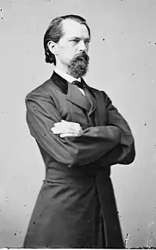
- John Brown Gordon - one of Robert E. Lee's most trusted Confederate generals during the American Civil War; governor of Georgia 1886-1890
- Frank Gordy (1904–1983) - founder of The Varsity restaurant chain
- William Guilford (1844–1909) - businessman and state legislator
- Bill Hartman - football running back for the Georgia Bulldogs and Washington Redskins before World War II
- John Holliman (1948–1998) - broadcast journalist best known as one of CNN's "Boys of Baghdad" during the first Persian Gulf War
- Marion Montgomery - poet, novelist, educator, and critic; close friend and critic of Flannery O'Connor
- Dallas Raines - Weather personality at KABC in Los Angeles
- Cedric Smith - African American painter
- Hunter Strickland - MLB pitcher
- Travon Walker- 1st overall pick in the 2022 NFL draft, selected by the Jacksonville Jaguars
References
- "Official City of Thomaston, Georgia Government Website". Official City of Thomaston, Georgia Government Website. Retrieved September 5, 2012.
- "2020 U.S. Gazetteer Files". United States Census Bureau. Retrieved December 18, 2021.
- "U.S. Census website". United States Census Bureau. Retrieved January 31, 2008.
- "US Board on Geographic Names". United States Geological Survey. October 25, 2007. Retrieved January 31, 2008.
- "Find a County". National Association of Counties. Retrieved June 7, 2011.
- "Profile for Thomaston, Georgia, GA". ePodunk. Retrieved September 5, 2012.
- "Thomaston". Georgia Gov. Retrieved September 5, 2012.
- Krakow, Kenneth K. (1975). Georgia Place-Names: Their History and Origins (PDF). Macon, GA: Winship Press. p. 225. ISBN 0-915430-00-2.
- "GeoHack - Thomaston, Georgia".
- "Decennial Census of Population and Housing by Decades". US Census Bureau.
- "1870 Census of Population - Georgia" (PDF). US Census Bureau. 1870.
- "1880 Census of Population - Georgia" (PDF). US Census Bureau. 1880.
- "1910 Census of Population - Georgia" (PDF). US Census Bureau. 1930.
- "1930 Census of Population - Georgia" (PDF). US Census Bureau. 1930. p. 253.
- "1940 Census of Population - Georgia" (PDF). US Census Bureau. 1940.
- "1950 Census of Population - Georgia" (PDF). US Census Bureau. 1980.
- "1980 Census of Population - Number of Inhabitants - Georgia" (PDF). US Census Bureau. 1980.
- "1990 Census of Population - General Population Characteristics - Georgia" (PDF). US Census Bureau. 1990.
- "Explore Census Data". data.census.gov. Retrieved December 13, 2021.
- "Thomaston". Georgia Department of Community Affairs. Retrieved September 5, 2012.
- Georgia Board of Education, Retrieved June 27, 2010.
- School Stats, Retrieved June 27, 2010.
- "Thomaston". Georgia Department of Community Affairs. Retrieved September 5, 2012.
- "Flint River Campus". Southern Crescent Technical College. Archived from the original on October 5, 2012. Retrieved September 5, 2012.
External links
- Official City of Thomaston, Georgia Government Website Portal style website, Government, Business, Library, Recreation and more
- City-Data.com Comprehensive Statistical Data and more about Thomaston
Municipalities and communities of Upson County, Georgia, United States | ||
|---|---|---|
| City |  Map of Georgia highlighting Upson County | |
| Town | ||
| CDPs |
| |
| Other unincorporated communities |
| |
| ||