Veraguas Province
Veraguas (Spanish pronunciation: [beˈɾa.ɣwas]) is a province of Panama, located in the centre-west of the country. The capital is the city of Santiago de Veraguas. It is the only Panamanian province to border both the Atlantic and Pacific oceans. It covers an area of 10,587.6 km² and in 2023 it had a population of 259,791.[4][5]
Veraguas Province
Provincia de Veraguas | |
|---|---|
Province | |
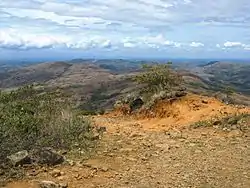 Panorama of Veraguas Province | |
 Flag | |
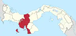 Location of Veraguas Province in Panama | |
| Country | Panama |
| Founded | July 9, 1508 |
| Capital city | Santiago |
| Area | |
| • Total | 10,587.5 km2 (4,087.9 sq mi) |
| Population (2023 census)[1] | |
| • Total | 259,791 |
| • Density | 25/km2 (64/sq mi) |
| Demonym | veraguense |
| GDP (PPP, constant 2015 values) | |
| • Year | 2023 |
| • Total | $3.3 billion[2] |
| • Per capita | $14,300 |
| Time zone | UTC-5 (Eastern Time) |
| ISO 3166 code | PA-9 |
| HDI (2017) | 0.727[3] high |
| Website | http://www.veraguas.org/ |
History
Veraguas was originally inhabited by the Veraguas culture.
Veraguas was explored by Christopher Columbus on his fourth voyage. He tried to establish the first colony in the new Spanish mainland but failed due to resistance from Indigenous peoples. Diego de Nicuesa also tried to establish a colony and failed, which made him create a colony to fight against the Indigenous population, which he named Nombre de Dios. Its capital, Santiago de Veraguas, was founded about 1636.[6]
It is said that its name comes from the indigenous word "Veracua" or "Viragua", though other theories abound. It is the only province in Panama with coastlines on both the Caribbean Sea and the Pacific Ocean. The majority of people live on the Pacific side; the Caribbean coast is mostly uninhabited.
Tourism
Veraguas has many groups of inhabitants, mainly of Spanish/Indigenous origin named campesinos. This land offers tourists and visitors close contact with nature. Forests, mountains, coasts, and islands where there are more than 200 varieties of orchids; more than 400 species of birds, in addition to mammals, reptiles, and insects.
Veraguas has various national parks. The Coiba National Park, (with the largest coral reef of the Pacific Coast of America), Cerro Hoya National Park (covers the southwest part of the Azuero Peninsula and the sea that surrounds it), Santa Fe National Park (a forest in the northern region), La Yeguada Forest reserve (with a great artificial lake for the production of electricity) and El Montuoso Forest reserve.
Beaches such as Playa Santa Catalina, Playa Mariato, Malena, and Torio offer great places for recreation, surfing, and fishing. Other famous touristic areas is the Iglesia de San Francisco de la Montaña. This church has a Baroque architecture and dates back to 1727. It was declared a National Historical Monument on January 27, 1937.
Administrative divisions
Veraguas Province is divided into 12 distritos (districts) and subdivided into 104 corregimientos.[7]
| Distrito | Area (km2) |
Population Estimate |
Population Estimate |
|---|---|---|---|
| Atalaya | 156 | 10,749 | 11,321 |
| Calobre | 806 | 12,112 | 12,159 |
| Cañazas | 789 | 17,737 | 18,022 |
| La Mesa | 511 | 12,256 | 12,062 |
| Las Palmas | 1,015 | 18,516 | 18,493 |
| Mariato | 1,381 | 5,584 | 5,564 |
| Montijo | 780 | 6,928 | 7,060 |
| Río de Jesús | 302 | 5,376 | 5,501 |
| San Francisco | 437 | 10,412 | 10,536 |
| Santa Fe | 1,920 | 16,423 | 17,341 |
| Santiago | 971 | 93,841 | 99,821 |
| Soná | 1,519 | 29,329 | 29,774 |
| District | Corregimientos (Subdivisions) |
Cabecera (Seat) |
|---|---|---|
| Atalaya District | Jesús Nazareno de Atalaya, El Barrito, La Montañuela, San Antonio, La Carrillo | Jesús Nazareno de Atalaya |
| Calobre District | Calobre, Barnizal, Chitra, El Cocla, El Potrero, La Laguna, La Raya de Calobre, La Tetilla, La Yeguada, Las Guías, Monjarás, San José | Calobre |
| Cañazas District | San Francisco Javier de Cañazas, Cerro de Plata, Los Valles, San Marcelo, El Picador, San José, El Aromillo, Las Cruces | San Francisco Javier de Cañazas |
| La Mesa District | La Mesa, Bisvalles, Boró, Llano Grande, San Bartolo, Los Milagros, El Higo | La Mesa |
| Las Palmas District | Las Palmas, Cerro de Casa, Corozal, El María, El Prado, El Rincón, Lolá, Pixvae, Puerto Vidal, Zapotillo, San Martín de Porres, Viguí, Manuel Encarnación Amador Terreros | Las Palmas |
| Mariato District | Mariato, Arenas, El Cacao, Quebro, Tebario | Mariato |
| Montijo District | Montijo, Isla Gobernadora, La Garceana, Leones, Pilón, Cébaco, Costa Hermosa, Unión del Norte | Montijo |
| Río de Jesús District | La Ermita de Río de Jesús, Catorce de Noviembre, Las Huacas, Los Castillos, Utira, Nuevo San Juan | La Ermita de Río de Jesús |
| San Francisco District | San Francisco de la Montaña, Corral Falso, Los Hatillos, Remance, San Juan, San José | San Francisco de la Montaña |
| Santa Fe District | Santa Fe, Calovébora, El Alto, El Cuay, El Pantano, Gatuncito, Río Luis, Rubén Cantú | Santa Fe |
| Santiago District | Santiago Apóstol de Veraguas, La Colorada, La Peña, La Raya de Santa María, Ponuga, San Pedro del Espino, Canto del Llano, Los Algarrobos, Carlos Santana Ávila, Edwin Fábrega, San Martín de Porres, Urracá, La Soledad, Rincón Largo, El Llanito | Santiago Apóstol de Veraguas |
| Soná District | Soná, Bahía Honda, Calidonia, Cativé, El Marañón, Guarumal, La Soledad, Quebrada de Oro, Río Grande, Rodeo Viejo, Hicaco | Soná |
See also
- Veragua
- Veraguas Club Deportivo, a football team
- F.C. Veraguas 2010, a football team
References
- Instituto Nacional de Estadística y Censo, Ciudad de Panamá.
- "TelluBase—Panama Fact Sheet (Tellusant Public Service Series)" (PDF). Tellusant. Retrieved 2024-01-11.
- "Sub-national HDI – Area Database – Global Data Lab". hdi.globaldatalab.org. Retrieved 2018-09-13.
- "Panama: Provinces & Major Urban Places - Population Statistics, Maps, Charts, Weather and Web Information". www.citypopulation.de. Retrieved 2024-03-10.
- Instituto Nacional de Estadística y Censo, Ciudad de Panamá.
- Gudeman, Stephen (2004), The Demise of a Rural Economy: From Subsistence to Capitalism in a Latin, Routledge, p. 17, ISBN 0-415-33042-4
- "Municipios (Distritos) de Veraguas". Editorial OX. Retrieved 15 November 2012.
- As at 1 July 2010; adjusted for under-enumeration in 2010 Census. Source: Instituto Nacional de Estadística y Censo, Ciudad de Panamá.
- Instituto Nacional de Estadística y Censo, Ciudad de Panamá.