Neighborhoods in Washington, D.C.
Neighborhoods in Washington, D.C., the capital of the United States, are distinguished by their history, culture, architecture, demographics, and geography. The names of 131 neighborhoods are unofficially defined by the D.C. Office of Planning.[1] Neighborhoods can be defined by the boundaries of wards, historic districts, Advisory Neighborhood Commissions, civic associations, and business improvement districts (BIDs); these boundaries will overlap. The eight wards each elect a member to the Council of the District of Columbia and are redistricted every ten years.
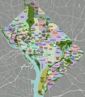
Neighborhoods in Washington, D.C.
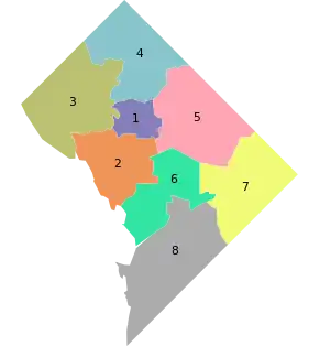
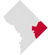
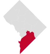
The eight wards of Washington, D.C. as of 2023
As the nation's capital Washington, D.C.'s local neighborhood history and culture is often presented as distinct from that of the national government.
List of neighborhoods by ward
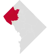
Ward 1
Ward 1 (2023–present)
- Ward 1 Councilmember: Brianne Nadeau
- Population (2022): 88,846[2]
- Adams Morgan
- Columbia Heights
- Howard University
- Kalorama Triangle
- LeDroit Park
- Lanier Heights
- Meridian Hill
- Mount Pleasant
- Park View
- Pleasant Plains
- Shaw (Parts of the neighborhood are also in Ward 2)
- U Street Corridor (Part of the neighborhood is also in Ward 2)
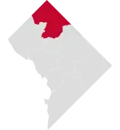
Ward 2
Ward 2 (2023–present)
- Ward 2 Councilmember: Brooke Pinto
- Population (2022): 89,518[3]
- Burleith
- Chinatown
- Downtown
- Dupont Circle
- Federal Triangle
- Foggy Bottom
- Georgetown
- Sheridan-Kalorama
- Logan Circle
- Mount Vernon Square (Part of the neighborhood is also in Ward 6)
- Penn Quarter
- Shaw (Parts of the neighborhood are also in Ward 1)
- Southwest Federal Center
- U Street Corridor (Part of the neighborhood is also in Ward 1)
- West End
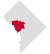
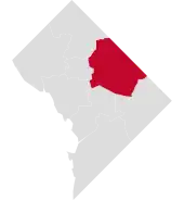
Ward 3
Ward 3 (2023–present)
- Ward 3 Councilmember: Matthew Frumin
- Population (2022): 81,883[4]
- American University Park
- Berkley
- Cathedral Heights
- Chevy Chase
- Cleveland Park
- Colony Hill
- Forest Hills
- Foxhall
- Friendship Heights
- Glover Park
- Kent
- Massachusetts Heights
- McLean Gardens
- North Cleveland Park
- Observatory Circle
- The Palisades
- Potomac Heights
- Spring Valley
- Tenleytown
- Wakefield
- Wesley Heights
- Woodland Normanstone
- Woodley Park
- Woodmont
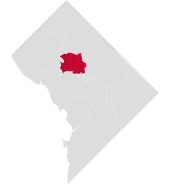
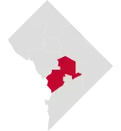
Ward 4
Ward 4 (2023–present)
- Ward 4 Councilmember: Janeese Lewis George
- Population (2022): 83,996[5]
- Barnaby Woods
- Brightwood
- Brightwood Park
- Chevy Chase (Part of the neighborhood is also in Ward 3)
- Colonial Village
- Crestwood
- Fort Totten
- Hawthorne
- Manor Park
- Petworth
- Riggs Park (also known as Lamond Riggs)
- Shepherd Park
- Sixteenth Street Heights
- Takoma
Ward 5
Ward 5 (2023–present)
- Ward 5 Councilmember: Zachary Parker
- Population (2022): 86,794[6]
- Arboretum
- Bloomingdale
- Brentwood
- Brookland
- Carver Langston
- Eckington
- Edgewood
- Fort Lincoln
- Fort Totten
- Gateway
- Ivy City
- Langdon
- Michigan Park
- North Michigan Park
- Pleasant Hill
- Queens Chapel
- Riggs Park (Part of the neighborhood is also in Ward 4)
- Stronghold
- Trinidad
- Truxton Circle
- Woodridge
Ward 6
Ward 6 (2023–present)
- Ward 6 Councilmember: Charles Allen
- Population (2022): 99,652[7]
- Barney Circle
- Buzzard Point
- Capitol Hill
- Lincoln Park
- Judiciary Square
- Kingman Park (Part of the neighborhood is also in Ward 7)
- Mount Vernon Triangle
- Near Northeast
- NoMa
- Shaw
- Southwest Waterfront
- Sursum Corda
- Swampoodle (Neighborhood from the 1850s to the 1910s replaced in large part today by NoMa and Near Northeast)
Ward 7
Ward 7 (2023–present)
- Ward 7 Councilmember: Vincent C. Gray
- Population (2022): 77,456[8]
- Benning
- Benning Heights
- Benning Ridge
- Burrville
- Capitol View
- Central Northeast
- Civic Betterment
- Deanwood
- Dupont Park
- East Corner
- East River Heights
- Eastland Gardens
- Fairfax Village
- Fort Davis
- Fort Dupont
- Fort Stanton
- Greenway
- Hillbrook
- Hillcrest
- Hill East
- Kenilworth
- Lincoln Heights
- Marshall Heights
- Mayfair
- Naylor Gardens
- Northeast Boundary
- Penn Branch
- Randle Highlands
- River Terrace
- Twining
Ward 8
Ward 8 (2023–present)
- Ward 8 Councilmember: Trayon White
- Population (2022): 77,756[9]
- Anacostia
- Barry Farm
- Bellevue
- Buena Vista
- Congress Heights
- Douglass
- Fairlawn
- Garfield Heights
- Good Hope
- Knox Hill
- Navy Yard
- Park Naylor
- Shipley Terrace
- Skyland
- Washington Highlands
- Woodland
References
- "Neighborhood Labels as Centroids". opendata.DC.gov. DC Office of Planning. Archived from the original on May 30, 2017. Retrieved May 31, 2017.
- Matters, DC Health. "DC Health Matters :: Demographics :: Ward :: Ward 1 :: Population". www.dchealthmatters.org. Retrieved April 22, 2024.
- Matters, DC Health. "DC Health Matters :: Demographics :: Ward :: Ward 2 :: Population". www.dchealthmatters.org. Retrieved April 22, 2024.
- Matters, DC Health. "DC Health Matters :: Demographics :: Ward :: Ward 3 :: Population". www.dchealthmatters.org. Retrieved April 22, 2024.
- Matters, DC Health. "DC Health Matters :: Demographics :: Ward :: Ward 4 :: Population". www.dchealthmatters.org. Retrieved April 22, 2024.
- Matters, DC Health. "DC Health Matters :: Demographics :: Ward :: Ward 5 :: Population". www.dchealthmatters.org. Retrieved April 22, 2024.
- Matters, DC Health. "DC Health Matters :: Demographics :: Ward :: Ward 6 :: Population". www.dchealthmatters.org. Retrieved April 22, 2024.
- Matters, DC Health. "DC Health Matters :: Demographics :: Ward :: Ward 7 :: Population". www.dchealthmatters.org. Retrieved April 22, 2024.
- Matters, DC Health. "DC Health Matters :: Demographics :: Ward :: Ward 8 :: Population". www.dchealthmatters.org. Retrieved April 22, 2024.
External links
Wikimedia Commons has media related to Neighborhoods in Washington, D.C..
- External link to D.C. neighborhood websites
- DC Genealogical Database
- National Capital Planning Commission
- D.C. Guide
- Washington DC, street by street (historic and modern photographs)
- Street map of Ward 4. Office of Councilmember Muriel Bowser.
| Topics |
|
|---|---|
| Government |
|
| Services | |
| Society |
|
| History |
|
| |
This article is issued from Wikipedia. The text is licensed under Creative Commons - Attribution - Sharealike. Additional terms may apply for the media files.