Bozburun is a peninsula south of Marmaris on the coast of Lycia in Turkey. It's also the name of the largest village there.
Understand
Get in
For long distance travel see Marmaris#Get in; the city is 100 km from Dalaman Airport and has buses from other major Turkish cities.
Bus 10 / 11 runs every two hours from Marmaris edge-of-town bus station to Değirmenyanı, Hisarönü, Orhaniye Kızkumu, Turgut, Selimiye and Bozburun, taking an hour.
Get around
See
Sedir Island

🌍 Sedir Island, in the Gulf of Gökova, is also known as Cleopatra Island. It features the ruins of Kedrai, including an amphiteatre, overgrown by wild olives. However, the highlight is the Cleopatra Beach, a strand of gleaming golden sands virtually non-existent anywhere else in the Eastern Mediterranean, accompanied by the milky turquoise waters of the cove. The legend has it that Marcus Antonius had this sand brought in from Egypt on the request of his lover, Cleopatra of Egypt. However scientists boringly conclude that this unique sodium bicarbonate-containing sand has actually formed of dissolved seashells. The sands are under heavy protection and removing any quantity of sand from the beach is forbidden, so no towels or shoes are allowed and anyone who set foot on the beach must have a shower before getting out. Sometimes even the bags are searched on the way out. Frequent boats to the island depart from a harbour near the highway, about 10 km north of Marmaris (watch out for the signpost). Boats cost 10 TL pp return, and admission to the island is a further 10 TL pp. There is a small kiosk on the island with fairly priced drinks. It doesn't sell any alcohol but it's allowed to bring in from the mainland with you (and any other snacks and drinks). The beach closes at 19:00 and it's best to visit the island in the morning, as early as possible, because the beach gets overcrowded especially after 13:00 during the high season.
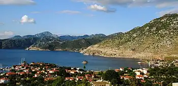
Bozburun Peninsula
Bozburun is the mountainous peninsula jutting out southwest from Marmaris. Its very convoluted coastline means that the relative direction of the sea changes ever so often as you progress; the deep blue meets up in the least expected locations and provides an unbelievably charming scenery.
The main road of the peninsula (48-53), all the way down to Serçe Limanı, is surfaced, if seriously winding all throughout and narrow in parts. Local minibuses depart from Marmaris, and there is at least once daily service across the peninsula to Taşlıca, the southernmost village; further from there, you are on your own. The Carian Trail is a 150-km long, waymarked and signposted hiking trail traversing the peninsula from one end to the other.
Most seaside locations offer accommodation, often in the form of family-run guesthouses.
- 🌍 Hisarönü is where you turn off from the D-400 Marmaris-Datça road into the peninsula.
- 🌍 Orhaniye is the site of Kızkumu ('Maiden's Sand'), a 1-km long, purple red sandbar an ankle deep below the water surface, almost completely closing a cove. The local folklore tells of a young woman, who in an attempt to meet her lover on the opposite shore, began building it by dirt she collected in her skirt, but failing her objective that was so close to be achieved, drowned.
- 🌍 Turgut is famous for its waterfalls, but you don't go there for a meager amount of water dropping from an unimpressive height, but for the lush setting.
- 🌍 Bayır is an inland village, and attracts off-roading enthusiasts.
- 🌍 Selimiye is at the head of an enchanting bay, spread into numerous lovely coves. As if that weren't pretty enough, an islet in the bay is topped by the picturesque ruins of a castle to boot. The town is laid-back and is said to resemble Marmaris before the tourism boom changed its face forever.
As you approach its southwestern tip, the peninsula becomes wilder: the human population gets sparser, the roads go narrower, the boulders grow bigger, and the dense pine forests of the northern half of the peninsula are replaced by Mediterranean scrub.
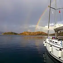
- 🌍 Bozburun is mainly a yachting harbour and offers associated repair and maintenance services.
- 🌍 Kızılyer is the coastal part of Söğüt, accessed by turning off before arriving at the village centre. It offers a range of restaurants and accommodation options, although expect many of them closed in the low season. Uçan Pansiyon (on the approach to the coast, +90 534 658 81 68, 200 TL) is a family-run guesthouse open year round, but don't expect much other than a clean room, a TV with Turkish channels, and an air-con that is unable to raise the room temperature to comfortable levels.
- During the low season, you may rent a fishing boat to tour around the bay from Kızılyer. For a 2-hour voyage expect to pay around 500 TL.
- 🌍 Söğüt is a single-street village on the hills. It has an ATM, a post office, an eatery (Söğüt Balıkçılık-Dursun Alan, meatballs and tasty fish sandwiches of locally-caught leerfish, akya, noon-midnight, 25-30 TL), and a bakery (homemade sweets, 08:00-19:00, 15-20 TL).
- 🌍 Saranda, officially Cumhuriyet, is the other seaside quarter of Söğüt, accessed from the turn-off at the village centre. It has a lot of businesses, and a very scenic, albeit pebble, beach opening out to the bay panorama.
- 🌍 Palamut, across the valley from Söğüt, is a few buildings strung along the road. It has a restaurant with a view over the valley, serving alcohol, a barbershop, and a very old plane tree.
- 🌍 Taşlıca is a nondescript, scruffy village surrounded by huge boulders as its name may suggest (Turkish for "stony").
- 🌍 Sindili was the location of the village of Fenaket (which should be a corrupted form of medieval Greek Phoinikoúdi, which itself should have derived from Phoenix, an ancient Carian city nearby), abandoned in the 1960s due to its unfavourable, remote location, with some of its inhabitants relocating to Söğüt, but mostly to then-newly founded Taşlıca. Its discernible ruins dot a hillside. Semi-wild flocks of livestock freely roam the area; the widespread terraces, now untamed and reclaimed by scrub, and windmill ruins indicate a much stronger agricultural activity in the past.
- 🌍 Serçe Limanı ("sparrow's harbour") is basically a fishermen's port in a fjord-like inlet deeply indenting into the land, and is the end of the line as far as anything on wheels is concerned.
The further sites are accessible only by boat or hiking trails.
- 🌍 Bozukkale was the fortress of the Carian city of Loryma. It marks one of the southernmost capes of the peninsula.
- 🌍 Karamaka was an Ottoman Greek village before its inhabitants had to relocate just across to Symi during the Turkish-Greek population exchange of the 1920s. Its evocative ruins, including that of a church dedicated to the Virgin Mary, lie at the western end of the peninsula.
Do
Buy
Eat
Drink
- Asarcık Vineyard is in the hills between Selimiye and Bozburun villages.
Sleep
Connect
As of June 2023, the villages along the west coast of the peninsula have 4G from Turkcell and Vodafone as far down as Bozburun and Sögüt, but only a patchy signal from Türk Telekom. 5G has not rolled out in Turkey.
Go next
- Marmaris is the big modern resort town you pass through to reach the rest of Turkey.
- Datça is the town at the tip of the long scenic peninsula stretching west. You'll have to come back the same way.
- Symi is the island seen to the southwest. It's Greek and there's no direct transport there, take the ferry from Marmaris to Rhodes then another to Symi.