X
wikiHow is a “wiki,” similar to Wikipedia, which means that many of our articles are co-written by multiple authors. To create this article, 57 people, some anonymous, worked to edit and improve it over time.
This article has been viewed 443,141 times.
Learn more...
Space. The final frontier. That's where you start, anyway, when you launch Google Earth. You can see the whole world shining in the night sky. You see the topography of the continents and the oceans, and only a suggestion of geopolitical boundaries.
But who cares about that! What you really want to do is see your house from here! How do you get there? Hop aboard the wikiHow tour bus and we'll show you what the birds see!
Steps
Method 1
Method 1 of 4:
Download Google Earth
-
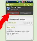
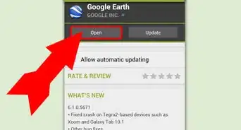
1First things first. Before you can see your house from overhead, you'll need to make sure you have Google Earth downloaded and installed. You can find it in Google Products at https://www.google.com/intl/en/about/products/index.html, under the Geo section:
- Follow the installation instructions, and when done, locate Google Earth and launch it.
-
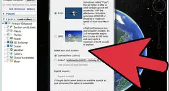
2Find your home. With Google Earth running, it's time for the fun stuff. Hang on!


Advertisement
Method 2
Method 2 of 4:
The easy way
-
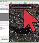
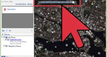
1Enter your address. In the top left corner, toggle open Search if it's not already open. When it is, you will see three buttons: Fly To, Find Business, and Directions. Click on Fly To.
- Enter in your street address, and click the magnifying glass. Google Earth will rotate (more, or less depending on the state or country you've entered), and zoom in pretty quickly to your neighborhood as seen from a few thousand feet. There will be a gray crosshair over your house, next to your address.
-
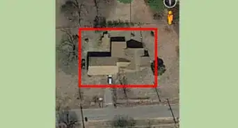
2Zoom in closer. This is nice, but still a long way from what you want to see. Double click just outside of the gray crosshairs, and let's get closer.
- Each double click brings you about halfway between where you were, and the ground.
- Continue clicking until you are very close. That's usually about three double-clicks.
- As you can see, it's a little blurry now. That's because the cameras that shoot the tops of houses are several miles up. They do a remarkable job despite that, but you were probably hoping for more.
-
3Move your cursor to the right side of the page. A set of controls will appear—–two virtual joysticks, one with a hand and one with an eye, and if Google has mapped your neighborhood, an orange human icon. Drag the icon to your house and release it. You will be placed on the ground, on your street!
-
4Look around. You can pan around, looking at your neighborhood—–you can even click on the street and "walk" along the road, anywhere Google has mapped!


Advertisement
Method 3
Method 3 of 4:
Let your clicking do the walking
-
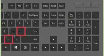
1Check out the controls. In the upper left of the Google Earth window, you'll see a set of controls. Use this guide:
-
2Find your country. If North America is not your home continent, rotate the earth by using the Rotate Joystick tool.
- Click the left arrow to rotate towards Asia, the right arrow to rotate towards Europe, the up arrow to head to the North Pole, and the down arrow should you live in Antarctica.
- Alternately, you can just click and drag Earth in the direction you wish to go.
Advertisement -
3Go to Paris, France for a trial. Rotate the Earth to the east (assuming a North American starting point). Using the joystick arrow as described, rotate the Earth to the east until France comes into view. If it's not in the center of the screen, use the joystick arrows to move it up or down towards the center. Use the outer ring of the Pan Joystick tool to rotate France into the proper position.
- When it's about centered on your screen, double-click on it.
- With the first double click, France is in the center of your screen, and you'll see the capital cities of Europe. In the north of France, you'll see Paris. Double-click Paris. After a quick and dizzying journey, you'll zoom from many miles above earth to around 2,000 feet (600 meters).
- Press the up arrow on the Pan Joystick, and the landscape of France will open up in front of you. It's as if you were looking straight down, and now you're lifting your head up. When you are looking out across the land instead of down on it, Use the outer ring of the Pan Joystick, and move the N icon to be due south. You'll now be looking at the city.
- Use the Zoom controls to zoom in. When you find a neighborhood to explore, click on the orange person icon, and place it to enter Street View.
-
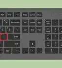
4Take a hike. Now that you're in Street View, you can use the arrow keys on your keyboard to "walk" the streets of Paris. Or your hometown. Or virtually any place in the world.


Advertisement
Method 4
Method 4 of 4:
Extra fun
-
1Look at the sun. When you're not in street view, from the View menu, select "Sun".
- If it's nighttime where you are, you won't see much. But rotate the Earth to where it's sunny, and you'll see the terminator—–no, not Arnold, but the place where day meets night. It's presented in real time, so you can watch the progression as people to the east of the terminator slip into darkness.
-
2Look at the moon. Why confine your explorations to Earth? From the View/Explore menu, select Moon.
- Visit where the Eagle landed, and the other Apollo missions, plus much more. And yes, in case you're wondering, there's a Street View there, too!
-
3Don't stop there! Explore the craters on Mars, or Messier objects in space. While there is no street view at NGC5458—–even Google has limits—–it's still space... the final frontier.
-
4Engage!


Advertisement
Community Q&A
-
QuestionWhat are the specific steps I need to take to find my neighbors house on Google Earth?
 Jackson QuesinberryCommunity AnswerType the full address into the search bar in the corner.
 -
QuestionHow can I get a view of a house on a particular day?
 Community AnswerUnfortunately, you cannot specify a time of day you want to see the house.
Advertisement
Things You'll Need
- A computer
- An Internet connection
- Google Earth


About This Article
Advertisement