This article was co-authored by wikiHow Staff. Our trained team of editors and researchers validate articles for accuracy and comprehensiveness. wikiHow's Content Management Team carefully monitors the work from our editorial staff to ensure that each article is backed by trusted research and meets our high quality standards.
wikiHow marks an article as reader-approved once it receives enough positive feedback. In this case, several readers have written to tell us that this article was helpful to them, earning it our reader-approved status.
This article has been viewed 562,654 times.
Learn more...
Latitude and longitude are points on the globe that help you find a specific location. When writing latitude and longitude, you want to make sure you format it correctly and use the right symbols so you are understood. You can identify varying points of latitude and longitude on maps and then write them out. Latitude and longitude can be written using one line of latitude and one line of longitude. For more specific points of latitude and longitude, coordinates can be written using degrees, minutes, seconds, and decimals.
Steps
Writing Basic Latitude and Longitude
-
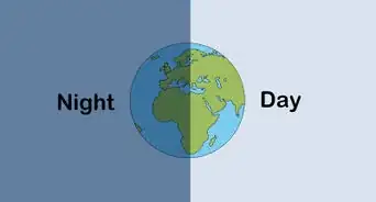
1Identify lines of longitude. Lines of longitude are vertical lines that stretch across the globe, moving from the North to South Pole. The Prime Meridian divides lines of longitude. This is the zero degree mark. When writing out lines of longitude, use the symbol "°" to indicate degrees.[1]
- Lines of longitude run around Earth vertically. Moving to the east, each line of longitude increases by one degree. You use the letter "E" to indicate a line of longitude that falls to the east of the Prime Meridian. For example, a line of longitude could be 30°E.
- Moving to the west, lines of longitude also increase by one degree per line. You write lines of longitude that fall to the west of the Prime Meridian using the symbol "W" to indicate west. For example, a line of longitude could be 15°W.
-
2Identify lines of latitude. Lines of latitude are horizontal lines dividing the globe. They stretch from east to west, starting at the equator. The equator's line of latitude is marked by 0 degrees. When writing latitude and longitude, use the symbol "°" to indicate degrees.[2]
- As you move north of the equator, lines of latitude increase by one degree until they reach 90 degrees. The 90 degree mark is the North Pole. Lines of latitude above the equator are marked using the letter "N" to mean North. For example, a line of latitude could be 15°N.
- As you move south of the equator, lines of latitude again increase by a single degree for each line until you reach the 90 degree mark. This is the South Pole. You use the symbol "S" to indicate south. For example, a line of latitude could be 30°S.
Advertisement -
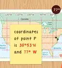
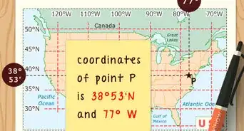
3Write the latitude and longitude coordinates. Find a location and figure out where the lines of latitude and longitude connect. For example, a location could be found along the latitude line 15°N and the longitude line 30°E. When writing latitude and longitude, write latitude first, followed by a comma, and then longitude.[3]
- For example, the above lines of latitude and longitude would be written as "15°N, 30°E."


Using Degrees, Minutes, and Seconds
-
1Identify the lines of latitude and longitude. Sometimes, you need to provide a more precise location than broad lines of latitude and longitude. Lines of latitude and longitude can be broken down by minutes and seconds. However, you must decipher the broad lines of latitude and longitude. Find which lines of latitude and longitude a location falls along.[4]
- For example, say your location falls on the latitude line 15°N and the longitude line 30°E.
-
2Find the minutes between each line of latitude and longitude. The space between each line of latitude and longitude is divided into one degree. This degree can be further divided into minutes. Imagine there are 60 even minutes separating each line of latitude and longitude. You can find maps online that will help you pinpoint the precise number of minutes your location falls along between each line of latitude or longitude. An apostrophe should be used to indicate the number of minutes between lines.[5]
- For example, if you find there are 23 minutes between the latitude lines, you would write this as "23'".
-
3Identify the seconds between each minute. Minutes are further divided into intervals of seconds. There are 60 seconds between each minute. Again, an online map can help you identify the precise number of seconds between each minute. A quotation mark is used to indicate the number of seconds.[6]
- For example, if there are 15 seconds between the minutes in your longitude line, you would write 15".
-
4Write degrees, then minutes, then seconds. After finding the precise coordinates, in minutes and seconds, for your lines of latitude and longitude, write them out in the correct order. Start with your line of latitude, writing the degrees, then the minutes, then the seconds. Then, add the North or South as the direction. Then, write a comma followed by your line of longitude in degrees, then minutes, then seconds. Then, add East or West as the direction.[7]
- For example, say you have a line of latitude at 15°N, 24 minutes, and 15 seconds. You have a line of longitude at 30°E, 10 minutes, and 3 seconds.
- This line of latitude and longitude would be written as, 15°24'15"N, 30°10'3"E.


Using Degrees and Decimal Minutes
-
1Identify the point of latitude and longitude. You can also use minutes followed by decimal points to identify latitude and longitude. However, you must again start by identifying the broad lines of latitude and longitude. Figure out where the lines of latitude and longitude meet to pinpoint your location.[8]
- For example, say your location falls at 15°N, 30°W.
-
2Figure out the minutes, including decimal points. Some maps identify minutes followed by decimal points rather than minutes followed by seconds. An online map should be able to provide you with the minutes broken down into decimals for each line of latitude and longitude. For example, a line of latitude may be found at 23.0256 minutes.[9]
-
3Determine whether numbers are negative or positive. When using the degrees and decimal minutes system, you do not use directions like north, south, east, and west. Instead, you use positive and negative numbers to determine where locations fall on a map.[10]
- Remember, lines of latitude fall north or south of the equator. When using decimals to indicate latitude and longitude, positive numbers fall north of the equator and negative numbers fall south of the equator. The number 23.456 falls north of the equator, while the number -23.456 falls south.
- Lines of longitude fall east or west of the Prime Meridian. Positive numbers fall east of the Prime Meridian, while negative numbers fall west. For example, the number 10.234 falls east of the Prime Meridian while the number -10.234 falls west of the Prime Meridian.
-
4Write out latitude and longitude. To write out the full location, start with the line of latitude. Follow this with the coordinates using minutes and decimals. Add a comma and then the line of longitude followed by its minutes and decimals. Remember to use positive and negative numbers to indicate the direction of coordinates. You do not use the degree symbol with this format.[11]
- For example, a line falls 15°N, 30°W. Identify the number of minutes and decimals and then write out the coordinates.
- The above example could be written as, "15 10.234, 30 -23.456."


Using Decimal Degrees
-
1Find the latitude and longitude. Degrees of latitude and longitude are often broken down by decimals. Rather than minutes and seconds, lines representing one degree are divided to get decimals pinpointing the exact location. First, find the right degrees of latitude and longitude.[12]
- For example, say your location falls at 15°N, 30°W.
-
2Figure out the decimals. An online map can break down lines of latitude and longitude using decimal points. Usually, decimal points are made up of five numbers.[13]
- For example, your location could be 15.23456 north and 30.67890 west.
-
3Identify whether numbers are positive or negative. Rather than using the words north, south, east, and west to indicate direction, positive or negative numbers are used. For lines of latitude, lines north of the equator are positive while lines south of the equator are negative. For lines of longitude, lines east of the Prime Meridian are positive while lines west of the Prime Meridian are negative.[14]
- For example, the line of latitude 15.23456 would be north of the equator, while the line -15.23456 would fall south of the equator.
- A line of longitude written out 30.67890 would fall east of the Prime Meridian, while the line -30.67890 would fall west.
-
4Write latitude and longitude, including decimals. It's simple to use the decimal degrees. You simply write out the line of latitude, including decimals, followed by the line of longitude, including decimals. Use positive or negative numbers to indicate direction.[15]
- For example, say a line falls 15°N, 30°W. Using the decimal degree system, you could write this as "15.23456, -30.67890."


Community Q&A
-
QuestionAre the digits to the right of the decimal point minutes and seconds respectively?
 Community AnswerUsually if you see format 12.345678°, this is not minutes and seconds, but decimal degrees.


References
- ↑ http://www.ubergizmo.com/how-to/read-gps-coordinates/
- ↑ http://www.ubergizmo.com/how-to/read-gps-coordinates/
- ↑ http://www.ubergizmo.com/how-to/read-gps-coordinates/
- ↑ http://www.ubergizmo.com/how-to/read-gps-coordinates/
- ↑ http://www.ubergizmo.com/how-to/read-gps-coordinates/
- ↑ http://www.ubergizmo.com/how-to/read-gps-coordinates/
- ↑ http://www.geomidpoint.com/latlon.html
- ↑ http://www.ubergizmo.com/how-to/read-gps-coordinates/
- ↑ http://www.ubergizmo.com/how-to/read-gps-coordinates/
- ↑ http://www.ubergizmo.com/how-to/read-gps-coordinates/
- ↑ https://www.maptools.com/tutorials/lat_lon/formats
- ↑ http://www.ubergizmo.com/how-to/read-gps-coordinates/
- ↑ http://www.ubergizmo.com/how-to/read-gps-coordinates/
- ↑ http://www.ubergizmo.com/how-to/read-gps-coordinates/
- ↑ http://www.ubergizmo.com/how-to/read-gps-coordinates/
About This Article

If you want to write latitude and longitude, first, identify the line of latitude on which a location sits. To find the latitude, look at the horizontal lines running north to south from the equator. Count the lines from the equator to the location and write down that number in degrees along with “N” or “S” depending on whether the location is north or south of the equator. Then, identify the line of longitude. Lines of longitude run vertically and stretch from east to west, so count each line between the location and the Prime Meridian to get its degrees. When you have that number, write it down in degrees and denote whether it lies east or west of the Prime Meridian. For example, a set of coordinates could look like “15 degrees N, 30 degrees E”. For more help, like how to write latitude and longitude using degrees, minutes, and seconds, scroll down.