Danjiangkou
Danjiangkou (Chinese: 丹江口; pinyin: Dānjiāngkǒu) is a county-level city in northwestern Hubei, China, bordering Henan province to the northeast. The city spans an area of 3,121 square kilometers, and has a population of approximately 478,000 as of 2017.[2]
Danjiangkou
丹江口市 | |
|---|---|
 | |
 Danjiangkou Location in Hubei | |
| Coordinates (Danjiangkou municipal government): 32°32′24″N 111°30′47″E | |
| Country | People's Republic of China |
| Province | Hubei |
| Prefecture-level city | Shiyan |
| Area | |
| • County-level city | 3,121 km2 (1,205 sq mi) |
| • Urban | 214.94 km2 (82.99 sq mi) |
| Population (2010)[1] | |
| • County-level city | 443,755 |
| • Estimate (2017)[2] | 478,000 |
| • Density | 140/km2 (370/sq mi) |
| • Urban | 209,300 |
| Time zone | UTC+8 (CST) |
| Website | djk |
Geography
Danjiangkou is located where the Dan River flows into the Han River.[3]
The city proper is situated near the Danjiangkou Dam on this river.
Climate
| Climate data for Danjiangkou (1981−2010) | |||||||||||||
|---|---|---|---|---|---|---|---|---|---|---|---|---|---|
| Month | Jan | Feb | Mar | Apr | May | Jun | Jul | Aug | Sep | Oct | Nov | Dec | Year |
| Record high °C (°F) | 21.4 (70.5) |
23.8 (74.8) |
31.0 (87.8) |
35.7 (96.3) |
37.8 (100.0) |
40.8 (105.4) |
40.6 (105.1) |
39.8 (103.6) |
39.5 (103.1) |
34.8 (94.6) |
29.1 (84.4) |
21.9 (71.4) |
40.8 (105.4) |
| Average high °C (°F) | 8.0 (46.4) |
10.6 (51.1) |
15.5 (59.9) |
22.4 (72.3) |
27.5 (81.5) |
30.9 (87.6) |
32.2 (90.0) |
31.2 (88.2) |
27.0 (80.6) |
22.1 (71.8) |
16.1 (61.0) |
10.4 (50.7) |
21.2 (70.1) |
| Daily mean °C (°F) | 3.4 (38.1) |
5.8 (42.4) |
10.2 (50.4) |
16.8 (62.2) |
21.9 (71.4) |
25.8 (78.4) |
27.7 (81.9) |
26.8 (80.2) |
22.5 (72.5) |
17.2 (63.0) |
11.1 (52.0) |
5.6 (42.1) |
16.2 (61.2) |
| Average low °C (°F) | 0.1 (32.2) |
2.2 (36.0) |
6.2 (43.2) |
12.3 (54.1) |
17.5 (63.5) |
21.6 (70.9) |
24.4 (75.9) |
23.6 (74.5) |
19.2 (66.6) |
13.8 (56.8) |
7.6 (45.7) |
2.2 (36.0) |
12.6 (54.6) |
| Record low °C (°F) | −7.0 (19.4) |
−8.6 (16.5) |
−2.9 (26.8) |
0.0 (32.0) |
8.7 (47.7) |
14.4 (57.9) |
17.7 (63.9) |
15.5 (59.9) |
10.1 (50.2) |
3.9 (39.0) |
−3.4 (25.9) |
−9.2 (15.4) |
−9.2 (15.4) |
| Average precipitation mm (inches) | 19.4 (0.76) |
22.5 (0.89) |
43.9 (1.73) |
57.5 (2.26) |
83.8 (3.30) |
85.0 (3.35) |
129.8 (5.11) |
142.3 (5.60) |
86.1 (3.39) |
65.1 (2.56) |
36.8 (1.45) |
16.5 (0.65) |
788.7 (31.05) |
| Average relative humidity (%) | 69 | 68 | 69 | 70 | 69 | 72 | 79 | 79 | 77 | 75 | 72 | 68 | 72 |
| Source: China Meteorological Data Service Center[4] | |||||||||||||
History
The area of present-day Danjiangkou belonged to both the Han and the Chu during the Warring States period.[1] After the Warring States period, the area was conquered by the Qin dynasty, which administered the area as Wudang County (武当县; 武當縣), after the nearby Wudang Mountains.[1] Wudang County belonged to the Nanyang Commandery.[1] In 208 CE, the area formed part of the newly established Nanxiang Commandery.[1] In 289 CE, under the Jin Dynasty, the area formed part of the newly established Shunyang Commandery.[1] During the Yongjia rebellion, many refugees from present-day Linfen, Shanxi settled in Wudang County.[1] In 618 CE, Wudang County became part of the newly formed Wudang Commandery (武当郡; 武當郡).[1] In 1119, Wudang Commandery became the Wudang Jun (武当军; 武當軍).[1] In 1276, the Wudang Jun became the Jun Prefecture.[1] In 1476, the area was merged into Xiangyang Fu.[1]
The area remained part of the Jun Prefecture until the establishment of the Republic of China in 1912, which re-organized the Jun Prefecture as Jun County (均县; 均縣).[1] In May 1914, Jun County was assigned to Hubei Circuit.[1] In 1932, it was moved to the province's 11th Administrative Circuit, and was moved to the province's 8th Administrative Circuit in 1936.[1]
On March 21, 1948, the county seat was taken by the People's Liberation Army, and the rest of the county was taken by March 28.[1] On June 2, the Jun County Democratic County Government was established by the Communist Party.[1] With the foundation of the People's Republic of China on October 1, 1949, the county's government was renamed to the Jun County People's Government.[1]
Jun County was briefly revoked in July 1960, and was merged into Guanghua County, before being re-established in 1962.[1] On August 19, 1983, Jun County became the county-level city of Danjiangkou.[1]
Administrative divisions
Danjiangkou is divided into 4 subdistricts, 12 towns, and 5 other township-level divisions.[5][6] These are subsequently divided into 41 residential communities and 223 administrative villages.[6]
The city's 4 subdistricts are Junzhou Road Subdistrict, Daba Road Subdistrict, Danzhao Road Subdistrict, and Sanguandian Subdistrict.[5][6]
The city's 12 towns are Tuguanya, Langhe, Dingjiaying, Liuliping, Yanchihe, Junxian, Xijiadian, Haoping, Shigu, Liangshuihe, Guanshan, and Longshan.[5][6]
The city's 5 other township-level divisions are Xingang Economic Development Management Area, Niuhe Forestry Development Management Area, Baiyangping Forestry Development Management Area, Dagou Forestry Development Management Area, and Wudangshan Tourism Economic Special Zone.[5][6]
Economy
In 2017, the city's GDP totaled ¥22.514 billion, the government budget totaled ¥2.089 billion, and foreign trade totaled USD 40.7918 million.[3]
Tourism
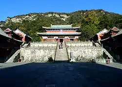
The city received 14.91 million tourists in 2017.[3] The Wudang Mountains, which run through the city, have been designated as a 5A Tourist Attraction.[3] The Danjiangkou Reservoir is also a major tourist attraction, and hosts watersports events and serves as a popular fishing spot.[3]
Transport
The Xiangyang–Chongqing railway and the Wuhan–Shiyan Expressway both run through the city.[3] Portions of the Wuhan–Shiyan high-speed railway and the Shiyan-Xichuan Expressway (十淅高速; Shí–Xī Gāosù) are under construction within Danjiangkou as of July 2020.[3]
Danjiangkou is the northwest terminus of the Hankou–Danjiangkou Railway.
References
- 丹江口市历史沿革 [Danjiangkou City Historical Development] (in Simplified Chinese). XZQH.org. 2014-08-06. Archived from the original on 2020-07-28. Retrieved 2020-07-28.
- Ministry of Housing and Urban-Rural Development, ed. (2019). China Urban Construction Statistical Yearbook 2017. Beijing: China Statistics Press. p. 66. Archived from the original on 18 June 2019. Retrieved 11 January 2020.
- 丹江口概况 [Danjiangkou Overview] (in Chinese (China)). Danjiangkou People's Government. 2020-07-09. Archived from the original on 2020-07-28. Retrieved 2002-07-28.
- 中国地面气候标准值月值(1981-2010) (in Simplified Chinese). China Meteorological Data Service Center. Retrieved 17 August 2022.
- 2019年统计用区划代码和城乡划分代码:丹江口市 [2019 Statistical Area Numbers and Rural-Urban Area Numbers: Danjiangkou City] (in Simplified Chinese). National Bureau of Statistics of the People's Republic of China. 2019. Archived from the original on 2020-07-28. Retrieved 2020-07-28.
- 区划人口 [Administrative Divisions & Population] (in Simplified Chinese). Danjiangkou People's Government. 2020-07-27. Archived from the original on 2020-07-28. Retrieved 2020-07-28.