Geispolsheim
Geispolsheim (French pronunciation: [ɡaispɔlsaim] (![]() listen); Alsatian: Gaispítze) is a commune in the Bas-Rhin department in Grand Est in north-eastern France.[3]
listen); Alsatian: Gaispítze) is a commune in the Bas-Rhin department in Grand Est in north-eastern France.[3]
Geispolsheim
Gäispítze | |
|---|---|
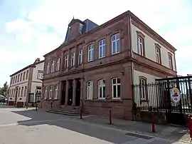 The town hall in Geispolsheim | |
 Coat of arms | |
Location of Geispolsheim | |
 Geispolsheim  Geispolsheim | |
| Coordinates: 48°31′N 7°39′E | |
| Country | France |
| Region | Grand Est |
| Department | Bas-Rhin |
| Arrondissement | Strasbourg |
| Canton | Lingolsheim |
| Intercommunality | Strasbourg Eurométropole |
| Government | |
| • Mayor (2020–2026) | Jean-Michel Schaeffer[1] |
| Area 1 | 21.95 km2 (8.47 sq mi) |
| Population | 7,603 |
| • Density | 350/km2 (900/sq mi) |
| Time zone | UTC+01:00 (CET) |
| • Summer (DST) | UTC+02:00 (CEST) |
| INSEE/Postal code | 67152 /67118 |
| Elevation | 139–155 m (456–509 ft) |
| 1 French Land Register data, which excludes lakes, ponds, glaciers > 1 km2 (0.386 sq mi or 247 acres) and river estuaries. | |
Geography
Geispolsheim is positioned 12 kilometres (7 mi) to the south of Strasbourg.
The construction of a railway between Strasbourg and Mulhouse involved the building in 1841 of a station approximately 3 kilometres (2 mi) to the east of the little town: this was followed by the development around the new station of a separate little conurbation, albeit one that always remained a part of the commune of Geispolsheim. The newer settlement was known as 'Geispolsheim-Gare' (Geispolsheim-Station), and retains the name even though the station itself was demolished in 1992, while the original settlement is still unofficially referred to as 'Geispolsheim-Village'. The two parts of the little town are linked by the departmental road RD84.
Today included in the Strasbourg Eurométropole, Geispolsheim is well positioned for future expansion: it already offers significant local employment and commercial opportunities in its industrial and artisanal zones.
Population
| Year | Pop. | ±% p.a. |
|---|---|---|
| 1968 | 3,758 | — |
| 1975 | 4,625 | +3.01% |
| 1982 | 4,712 | +0.27% |
| 1990 | 5,546 | +2.06% |
| 1999 | 7,031 | +2.67% |
| 2007 | 7,067 | +0.06% |
| 2012 | 7,124 | +0.16% |
| 2017 | 7,540 | +1.14% |
| Source: INSEE[4] | ||
See also
References
- "Répertoire national des élus: les maires" (in French). data.gouv.fr, Plateforme ouverte des données publiques françaises. 13 September 2022.
- "Populations légales 2020". The National Institute of Statistics and Economic Studies. 29 December 2022.
- INSEE commune file
- Population en historique depuis 1968, INSEE