Heislerville, New Jersey
Heislerville is an unincorporated community and census-designated place[4] (CDP) that is part of Maurice River Township in Cumberland County in the U.S. state of New Jersey.[1][5][6] It was named after the Heisler family, prominent members of the Methodist Episcopal Church established here in 1828.[7]
Heislerville, New Jersey | |
|---|---|
 Heislerville United Methodist Church | |
 Heislerville  Heislerville  Heislerville | |
| Coordinates: 39°13′23″N 74°59′33″W[1] | |
| Country | |
| State | |
| County | Cumberland |
| Township | Maurice River |
| Area | |
| • Total | 0.72 sq mi (1.86 km2) |
| • Land | 0.72 sq mi (1.86 km2) |
| • Water | 0.00 sq mi (0.00 km2) |
| Elevation | 10 ft (3 m) |
| Population | |
| • Total | 227 |
| • Density | 316.16/sq mi (122.03/km2) |
| Time zone | UTC-5 (Eastern (EST)) |
| • Summer (DST) | UTC-4 (Eastern (EDT)) |
| GNIS feature ID | 877035[1] |
The community borders the Maurice River and Delaware Bay; bayshore areas are East Point and Thompson's Beach, now flooded by the state of New Jersey for use as a bird watch conservatory. The East Point Lighthouse was built in 1849, located on the northern side of Delaware Bay at the mouth of the circuitous Maurice River. The lighthouse is a restful place to fish or hike and is open a few days every year. It is still a working light house but is only operated remotely, having not been staffed for years. It was added to the National Register of Historic Places in 1995 for its significance in engineering, maritime history, and transportation.[8]
Today, aside from truck gardens, small fishing operations, and a couple of marinas on state-leased land off Matt's Landing Road; the town has no shops or businesses. The major employer of townspeople is the state of New Jersey as Maurice River Township is home to three prisons; Bayside, South Woods, and Southern State. In addition to the Heislerville United Methodist Church, located within the community is the Heislerville Volunteer Fire Company.
Demographics
Heislerville's population as of the 2020 United States census was 227,[3] while the 2010 census showed a count of 451. There are approximately 200 housing units in its approximate nine-mile radius of which 8.17 square miles (21.2 km2) is land and 0.02 square miles (0.052 km2) is water.
| Census | Pop. | Note | %± |
|---|---|---|---|
| 2020 | 227 | — | |
| U.S. Decennial Census[9] | |||
Gallery
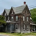 HABS documented house at Main Street and Glade Road
References
- "Heislerville". Geographic Names Information System. United States Geological Survey, United States Department of the Interior.
- "ArcGIS REST Services Directory". United States Census Bureau. Retrieved October 11, 2022.
- "Census Population API". United States Census Bureau. Retrieved October 11, 2022.
- State of New Jersey Census Designated Places - BVP20 - Data as of January 1, 2020, United States Census Bureau. Accessed February 15, 2023.
- "Locality Search". State of New Jersey.
- Gannett, Henry (January 28, 1895). "A Geographic Dictionary of New Jersey". U.S. Government Printing Office – via Google Books.
- "House, Main Street & Glade Road, Heislerville, Cumberland County, NJ" (PDF). HABS NJ-1194. Historic American Buildings Survey. 1992.
{{cite journal}}: Cite journal requires|journal=(help) - "National Register Information System – (#95001047)". National Register of Historic Places. National Park Service. November 2, 2013.
- "Census of Population and Housing". Census.gov. Retrieved June 4, 2016.
External links
 Media related to Heislerville, New Jersey at Wikimedia Commons
- Historic American Buildings Survey (HABS) No. NJ-1194, "House, Main Street & Glade Road, Heislerville, Cumberland County, NJ", 1 photo, 3 data pages, 1 photo caption page
Municipalities and communities of Cumberland County, New Jersey, United States | ||
|---|---|---|
| Cities |  Map of New Jersey highlighting Cumberland County | |
| Borough | ||
| Townships | ||
| CDPs |
| |
| Other communities | ||
| Footnotes | ‡This populated place also has portions in an adjacent county or counties | |