Himalayan Expressway
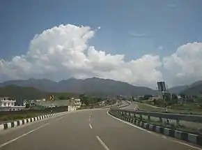
The Himalayan Expressway is a 27.5 km stretch of highway in India that runs through the Shivaliks at the trijunction of Haryana, Punjab, and Himachal Pradesh. It is part of the Chandigarh–Shimla Expressway which connects Zirakpur in Punjab to Parwanoo in Himachal Pradesh.[1] The stretch runs through 2 km in Zirakpur, Punjab, 21 km in Panchkula, Haryana, and 4.5 km in Parwanoo, Himachal Pradesh. It was constructed by Jaypee Group.
| Himalayan Expressway | |
|---|---|
 | |
| Route information | |
| Maintained by National Highways Authority of India (NHAI) | |
| Length | 27.5 km (17.1 mi) |
| Existed | May 2012–present |
| Major junctions | |
| South end | Zirakpur, Punjab |
| North end | Parwanoo, Himachal Pradesh |
| Location | |
| Country | India |
| States | Punjab, Haryana, & Himachal Pradesh |
| Major cities | Zirakpur, Panchkula, Parwanoo |
| Highway system | |
Benefits
Although the road cuts short the distance between Zirakpur and Parwanoo by only 3 km, but it helps save fuel and cuts time of travel between Delhi and Shimla by 1 hour to 7 hours, by helping commuters bypass the congested towns of Pinjore and Kalka.
Salient Features
- The stretch has 32 structures including a rail overbridge, two flyovers and 11 bridges.
- Total Project cost Rs.412 Crore.[2]
- The 14-lane toll plaza at Chandimandir, is the first plaza in India to be fitted with radio frequency identification (RFID) technology.
- For better monitoring of mishaps, it is fitted with video incident detection system (VIDS).
References
- Himalayan Expressway to cut travel time to Shimla – The Times of India
- "Jaypee commissions Rs. 412cr Himalayan expressway". NBM&CW. 5 May 2012. Archived from the original on 7 June 2012.


This article is issued from Wikipedia. The text is licensed under Creative Commons - Attribution - Sharealike. Additional terms may apply for the media files.