Hobucken, North Carolina
Hobucken is an unincorporated community and census-designated place (CDP) in Pamlico County, North Carolina, United States.[2] Its population was 38 as of the 2020 census. Hobucken has a post office with ZIP code 28537.[3][4] North Carolina Highway 33 and North Carolina Highway 304 pass through in the community.
Hobucken, North Carolina | |
|---|---|
 Hobucken, North Carolina  Hobucken, North Carolina | |
| Coordinates: 35°14′45″N 76°34′09″W | |
| Country | United States |
| State | North Carolina |
| County | Pamlico |
| Area | |
| • Total | 5.11 sq mi (13.24 km2) |
| • Land | 5.08 sq mi (13.16 km2) |
| • Water | 0.03 sq mi (0.08 km2) |
| Elevation | 3 ft (0.9 m) |
| Population (2020) | |
| • Total | 99 |
| • Density | 19.49/sq mi (7.53/km2) |
| Time zone | UTC-5 (Eastern (EST)) |
| • Summer (DST) | UTC-4 (EDT) |
| ZIP code | 28537 |
| Area code | 252 |
| GNIS feature ID | 986862[2] |
References
- "ArcGIS REST Services Directory". United States Census Bureau. Retrieved September 20, 2022.
- "Hobucken". Geographic Names Information System. United States Geological Survey, United States Department of the Interior.
- United States Postal Service (2012). "USPS - Look Up a ZIP Code". Retrieved 2012-02-15.
- "Postmaster Finder - Post Offices by ZIP Code". United States Postal Service. Retrieved March 6, 2014.
- "Census of Population and Housing". Census.gov. Retrieved June 4, 2016.
Municipalities and communities of Pamlico County, North Carolina, United States | ||
|---|---|---|
| Towns | 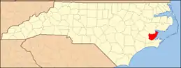 | |
| CDP | ||
| Unincorporated community | ||
This article is issued from Wikipedia. The text is licensed under Creative Commons - Attribution - Sharealike. Additional terms may apply for the media files.