Horní Studénky
Horní Studénky is a municipality and village in Šumperk District in the Olomouc Region of the Czech Republic. It has about 300 inhabitants.
Horní Studénky | |
|---|---|
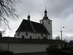 Church of Saint Linhart | |
 Flag  Coat of arms | |
 Horní Studénky Location in the Czech Republic | |
| Coordinates: 49°57′10″N 16°48′43″E | |
| Country | |
| Region | Olomouc |
| District | Šumperk |
| First mentioned | 1353 |
| Area | |
| • Total | 7.24 km2 (2.80 sq mi) |
| Elevation | 515 m (1,690 ft) |
| Population (2022-01-01)[1] | |
| • Total | 345 |
| • Density | 48/km2 (120/sq mi) |
| Time zone | UTC+1 (CET) |
| • Summer (DST) | UTC+2 (CEST) |
| Postal codes | 789 01 |
| Website | www |
Horní Studénky lies approximately 12 kilometres (7 mi) west of Šumperk, 52 km (32 mi) north-west of Olomouc, and 172 km (107 mi) east of Prague.
Etymology
The name is probably derived from Czech word studánky (i.e. "springs") and refers to a large number of springs flowing from the slopes around the village. There is also a theory that the name is derived from studený, i.e. "cold".[2]
History
The first written mention of Horní Studénky is from 1353.[2]
Sights
The landmark of Horní Studénky is the Church of Saint Linhart. The original church was built shortly after the village was founded. The current building dates from 1666.[2]
References
- "Population of Municipalities – 1 January 2022". Czech Statistical Office. 2022-04-29.
- "Historie v datech" (in Czech). Obec Horní Studénky. Retrieved 2022-10-08.
Wikimedia Commons has media related to Horní Studénky.
This article is issued from Wikipedia. The text is licensed under Creative Commons - Attribution - Sharealike. Additional terms may apply for the media files.