Jondor
Jondor (Uzbek: Jondor/Жондор, Russian: Жондор) is an urban-type settlement in Bukhara Region in Uzbekistan. It is the seat of Jondor District.[1]
Jondor | |
|---|---|
urban-type settlement | |
 Jondor Location in Uzbekistan | |
| Coordinates: 39°44′N 64°11′E | |
| Country | |
| Region | Bukhara Region |
| District | Jondor District |
| Urban-type settlement status | 1983 |
| Population (2001) | |
| • Total | 8,700 |
| Time zone | UTC+5 (UZT) |
From Wikipedia, the free encyclopedia
This term has other meanings, see Sverdlovsk (meanings).
39°44′50″ s. sh. 64°11′55″ E e.HGЯO
Former names before 1936 - Jandar
until 1938 - Fayzulla Khodjaev
until 1981 - Sverdlov (Sverdlovsk)
Confessions of Islam (Sunnism)
Jondor is located 21 km west of the center of Bukhara and 465 km southwest of Tashkent.
- "Classification system of territorial units of the Republic of Uzbekistan" (in Uzbek and Russian). The State Committee of the Republic of Uzbekistan on statistics. July 2020.
From Wikipedia, the free encyclopedia
This term has other meanings, see Sverdlovsk (meanings).
39°44′50″ s. sh. 64°11′55″ E e.HGЯO
Former names before 1936 - Jandar
until 1938 - Fayzulla Khodjaev
until 1981 - Sverdlov (Sverdlovsk)
Confessions of Islam (Sunnism)
Jondor is located 21 km west of the center of Bukhara and 465 km southwest of Tashkent.
Capital: Bukhara | ||
| Districts | 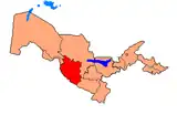 | |
| Cities | ||
| Towns | ||