Kankan
Kankan (Mandingo: Kánkàn; N’ko: ߞߊ߲ߞߊ߲߫) is the largest city in Guinea in land area, and the third largest in population, with a population of 198,013 people as of 2020.[3] The city is located in eastern Guinea about 555 kilometres (345 miles) east of the national capital Conakry.
Kankan | |
|---|---|
Sub-prefecture and town | |
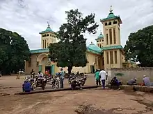
.jpg.webp) Downtown Kankan | |
 Kankan | |
| Coordinates: 10°23′N 9°18′W | |
| Country | |
| Region | Kankan Region |
| Prefecture | Kankan Prefecture |
| Government | |
| • Mayor | Mory Kolofon Diakité[1] |
| Population (2020[2]) | |
| • Total | 198,013 |
The city is the capital and largest town of the Kankan Prefecture and of the Kankan Region. The population is largely from the Mande ethnic group.
The Kankan region now has more than 6,167,904 inhabitants (2021). It is the most populous region in Guinea. The region has five (5) prefectures (Kankan, Kérouané, Kouroussa, Mandiana and Siguiri), 53 sub-prefectures, 5 urban communes, 53 rural communes , 878 arrondissements, 68 neighborhoods and 1864 sectors.
Etymology
Kankan has two different names before its actually names. It was first named as Fadou, which means satiety's land, before it was renamed as Nabaya, which means the comer's Land (the new arrivals home), it spent a long time under this name. After returning on their immigration from Fouta Djallon, it was renamed as Kankan during Arafan Kabine's rule (patriarch of Kankan) which means the defenses (or God protect our city from all the attacks), due to successives attacks by the unfaithful people, and this is the really history of the settlement, which was written by the city founder and successors in Ajami.
But there's other terms which saying that during the Kaba's negotiation of the place from Conde's, that they were informed to installed where the people's made the Kankan (A fixed wood that Mande's often used as a door), and there were no other humans settlement between Makonon and Diankana (30 km) during this moment.
The other terms are using by the griots, that there were too much of the Kankan-Kissè (an arborescente name) in to the area that Kankan Settled in, so the Conde's told the Kaba to install this place, which made the Kaba to rename it as Kankan. Those terms have no sources and the speakers didn't know nothing about Kankan's history.
Geography
The city is located on the Milo River, a tributary of the Niger River.
History
Early history
After spending two years in Bankalan with his eldest brother (Fédé-Moudouba), before founding his first village in some where, Dauda Kaba found a new place and demanded Fedemoudou Conde in Makonon to give him. He started asking him until he understood that he's the son of his sister (Dousou Conde), he then asked him, where do you need? I am thinking about the Drametou area. He gives him and says: anywhere that you are thinking around there, I give you.
At this moment, the place was a hamlet's jungle with numerous baobab trees. The village was founded around 1690's. The place where he built his first house is actually the residence of the president located in Kankan, named as (Villas Sylli).
Defense or war
Kankan didn't have representative authority, king or other forms of governing. They formed the theocratic and cultural form and held a few of the army to protect the town from the slave sellers and holders. They spent a long time teaching the children with the Quran and other cultural activities. They were also building little fortresses (Jin) in some parts of the town for the people's shelter during the wars.
In 1767, when they got information that Conde-béréma Diakité (Wasolon) is preparing to attack their state, all the inhabitants of Bate including Kankan, were immigrated to Fouta Jalon especially Timbo and Fougoumba due to Islamic relation between the two theocratic states. The immigration took seven years. On their return from Fouta Djallon, the city was rebuilt as six districts and two were renamed after their immigration towns, Fougoumba and Timbon, and the latest one is actually remaining.
Another war against Kankan was prepared by other kings of Wasolon, Diédi and Djiba (or DJI), to first conquering Kankan the capital of the state, which was defeated by the Kankan's army directed by Alpha-Mamoudou Kaba.
Alliance with Samori and conflict
After defeating Jamoro Aji and Ouorokodo Famoudou in the Battle of Saman-Saman, Kankan sent the emissaries to sign up the theocratic alliance with Samori and incited to fight the unfaithful people and signed the peace treaty with him.
While Samori was trying to conquering the Cissé's kingdom, he invited Bate (Kankan) to be helping him on this war, which Kankan categorically refused, due to a marriage, because one of the Séré-Bréma's wife (Mali Kaba) was married from Kankan. Which Samori judged as a betrayal, and sent troops to besiege the town within three months. During these sieges, Mamadi Kaba (commonly known as Dayi Kaba) miracles moved in the besieged city, and the town was totally surrounded in 1881's. During this siege, Karifamoudouya sent troops to break the siege over Kankan, but they were repealed and massacred until they crossed the River (Gbourouroun), which is the border between two cities.
He ran and joined the French colonial forces in Ségou, participating all the war until Kankan was freed from Samori's troops in 1891, and on their fleeing, the Sofas put fire into the city.
Kankan was founded by the Soninke people in the 18th century, after which it became an important trading centre, particularly for kola nuts, and the capital of the Baté Empire.[4]
The population of the city is predominantly from the Mandinka ethnic group and their language is widely spoken throughout the city.
The French explorer René Caillié spent a month in Kankan in 1827 on his journey from Boké, in present-day Guinea, to Djenné and Timbuktu in Mali. He arrived with a caravan transporting kola nuts. He described the visit in his book Travels through Central Africa to Timbuctoo. The town had a population of 6,000 inhabitants and was an important commercial centre with a market held three times a week. Instead of having a surrounding mud wall, the town was defended by quickset hedges. The chief of the town refused Caillié permission to travel along the river to the north as the town of Kankan was fighting for control of the Bouré gold producing area around Siguiri and the Tinkisso River. Instead Caillié left the town heading east in the direction of Minignan in the Ivory Coast.[5][6]
The town was conquered by Samory Touré in 1881 and occupied by the French in 1891.
In 1904, the city is chosen as the final destination during the construction of the Conakry railway in Kankan.
Climate
Kankan has a tropical savanna climate (Köppen climate classification Aw).
| Climate data for Kankan | |||||||||||||
|---|---|---|---|---|---|---|---|---|---|---|---|---|---|
| Month | Jan | Feb | Mar | Apr | May | Jun | Jul | Aug | Sep | Oct | Nov | Dec | Year |
| Average high °C (°F) | 36.5 (97.7) |
38.1 (100.6) |
38.9 (102.0) |
38.8 (101.8) |
37.1 (98.8) |
33.2 (91.8) |
32.2 (90.0) |
31.7 (89.1) |
32.7 (90.9) |
33.9 (93.0) |
34.7 (94.5) |
35.2 (95.4) |
35.3 (95.5) |
| Daily mean °C (°F) | 24.3 (75.7) |
26.3 (79.3) |
29.6 (85.3) |
30.1 (86.2) |
28.3 (82.9) |
26.4 (79.5) |
25.3 (77.5) |
25.1 (77.2) |
25.5 (77.9) |
26.4 (79.5) |
27.0 (80.6) |
23.8 (74.8) |
26.5 (79.7) |
| Average low °C (°F) | 10.8 (51.4) |
13.3 (55.9) |
17.0 (62.6) |
20.2 (68.4) |
19.6 (67.3) |
18.8 (65.8) |
18.9 (66.0) |
18.8 (65.8) |
18.9 (66.0) |
19.0 (66.2) |
13.9 (57.0) |
11.0 (51.8) |
16.7 (62.1) |
| Average rainfall mm (inches) | 2 (0.1) |
1 (0.0) |
24 (0.9) |
67 (2.6) |
134 (5.3) |
204 (8.0) |
262 (10.3) |
322 (12.7) |
304 (12.0) |
131 (5.2) |
20 (0.8) |
1.2 (0.05) |
1,472.2 (57.95) |
| Average rainy days (≥ 1.0 mm) | 1 | 1 | 3 | 6 | 11 | 15 | 19 | 22 | 21 | 13 | 3 | 1 | 116 |
| Average relative humidity (%) | 38 | 35 | 38 | 49 | 63 | 73 | 77 | 79 | 77 | 75 | 57 | 46 | 59 |
| Mean monthly sunshine hours | 262 | 236 | 249 | 220 | 234 | 216 | 169 | 159 | 191 | 221 | 241 | 260 | 2,658 |
| Source: NOAA[7] | |||||||||||||
Education
The Julius Nyerere University of Kankan was founded in 1964.
Places of worship
Among the places of worship, they are predominantly Muslim mosques. There are also Christian churches and temples : Roman Catholic Diocese of Kankan (Catholic Church), Église Protestante Évangélique de Guinée (Alliance World Fellowship), Assemblies of God.[8]
Transports
It is home to the Kankan Airport and a river port. Kankan is the terminus of the lightduty narrow gauge railway from Conakry (traffic suspended since 1993). The N1 highway connects the city with Nzerekore in the south.
References
- "Commune de Kankan : Mory Kolofon Diakité du RPG élu maire !". conakryinfos.com (in French). 2018. Retrieved 5 November 2021.
- "Etat et Structure de la Population Recensement General de la Population et de l'habitation 2020" (PDF). Direction Nationale de la Statistique de Guinée (in French). Retrieved 27 March 2020.
- "Etat et Structure de la Population Recensement General de la Population et de l'habitation 2014" (PDF). Direction Nationale de la Statistique de Guinée (in French). Retrieved 27 March 2020.
- Britannica, Kankan, britannica.com, USA, accessed on June 23, 2019
- Caillié, René (1830). Travels through Central Africa to Timbuctoo; and across the Great Desert, to Morocco, performed in the years 1824-1828 (Volume 1). London: Colburn & Bentley. pp. 254–286.
- Quella-Villéger, Alain (2012). René Caillié, l'Africain : une vie d'explorateur, 1799-1838 (in French). Anglet, France: Aubéron. pp. 71–75. ISBN 978-2-84498-137-0.
- "Kankan Climate Normals 1961–1990". National Oceanic and Atmospheric Administration. Retrieved July 6, 2015.
- J. Gordon Melton, Martin Baumann, ‘‘Religions of the World: A Comprehensive Encyclopedia of Beliefs and Practices’’, ABC-CLIO, USA, 2010, p. 1279
Capital: Kankan | ||
| Sub-prefectures |  | |