Kloosterburen
Kloosterburen is a village in the Dutch province of Groningen. It is located in the municipality of Het Hogeland. The village developed around a monastery. Kloosterburen was a separate municipality until 1990, when it was merged with Leens, Ulrum and Eenrum. During the combining of the four municipalities they were called 'de LEUK gemeenten'.[4] In 2019, it became part of Het Hogeland.[5]
Kloosterburen | |
|---|---|
 Village library | |
 Kloosterburen Location of Kloosterburen in Groningen  Kloosterburen Kloosterburen (Netherlands) | |
| Coordinates: 53°23′10″N 6°23′26″E | |
| Country | Netherlands |
| Province | Groningen |
| Municipality | Het Hogeland |
| Established | c. 1175 |
| Area | |
| • Total | 32.24 km2 (12.45 sq mi) |
| Elevation | 1 m (3 ft) |
| Population (2021)[1] | |
| • Total | 1,430 |
| • Density | 44/km2 (110/sq mi) |
| Postal code | 9977 |
| Dialing code | 0595[3] |
History
Around 1175, a monastery was established by Taco, a Premonstratensian from Mariëngaarde. In 1204, the monastery was named Oldeklooster after Nijeklooster, a convent was established at a distance of 15 minutes by foot.[6][7]: 12 A village developed around Oldeklooster which was named Kloosterburen.[8] At the end of the 16th century, Nijeklooster was destroyed by the Protestants.[9] Oldeklooster was closed, and the church became Dutch Reformed, however Oldeklooster is one of the two monasteries which still exist in Groningen.[7]: 12
A large part of the population remained Roman Catholic, and in 1840 permission was given to re-establish a parish. The neo-gothic Saint Willibrord Church was built in 1868–69 by Pierre Cuypers.[6] The church has a 56 metres (184 ft) tall tower.[5] Kloosterburen is the most northern place in the Netherlands to celebrate Carnival as Kronkeldörp.[10][5] From 1926 to 1970, the Roosendaal brothers of the Sacred Heart lived and worked in a Kloosterburen convent, which was converted into Hotel Het Klooster in 1970.[11]
In 2011, the public library closed down. The village community bought the inventory, and operates a free of charge village library.[5] Kloosterburen was an independent municipality until 1990, when it merged into De Marne. In 2019, it became part of Het Hogeland.[5]
Notable people
- Sietje Gravendaal-Tammens (1914-2014), Dutch resistance leader.[12]
Gallery
 Protestant Church in 1942
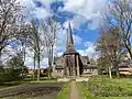 Monastery garden
.jpg.webp) Village street
Village street Saint Willibrord Church
References
- "Kerncijfers wijken en buurten 2021". Central Bureau Statistics. Retrieved 3 March 2022.
- "Postcodetool for 9977PP". Actueel Hoogtebestand Nederland (in Dutch). Het Waterschapshuis. Retrieved 3 March 2022.
- "Netnummer 0595". Netnummer (in Dutch). Retrieved 3 March 2022.
- Ad van der Meer and Onno Boonstra, Repertorium van Nederlandse gemeenten, KNAW, 2011.
- "Kloosterburen". Plaatsengids (in Dutch). Retrieved 3 March 2022.
- Redmer Alma (1998). Kloosterburen (in Dutch). Zwolle: Waanders Uitgevers. p. 148. ISBN 90 400 9258 3. Retrieved 3 March 2022.
- M.J. Gasman (1910). Parochie Den Hoorn (in Dutch). Retrieved 3 March 2022.
- P.J. Blok (1923). Geschiedkundige atlas van Nederland (in Dutch). The Hague: Nijhoff. pp. 33–34.
- "Tussen Damsterdiep en Fivelboezoem" (PDF). Noorderbreedte (in Dutch). p. 4. Retrieved 3 March 2022.
- "Carnaval kan losbarsten". Nieuwsblad van het Noorden (in Dutch). 24 February 1990. Retrieved 3 March 2022.
- Inder Bugarin (November 23, 2003). "Modifica Holanda el uso de templos". Internacional. Reforma (Mexico) (in Spanish). p. 4. Retrieved March 22, 2012.
- "Tammens, Sietje (1914-2014)". Huygens Institute for the History of the Netherlands (in Dutch). Retrieved 8 July 2020.
External links
 Media related to Kloosterburen at Wikimedia Commons