Lockrose
Lockrose is a rural locality split between the Lockyer Valley Region and Somerset Region of Queensland, Australia.[2][3] In the 2016 census, Lockrose had a population of 562 people.[1]
| Lockrose Queensland | |||||||||||||||
|---|---|---|---|---|---|---|---|---|---|---|---|---|---|---|---|
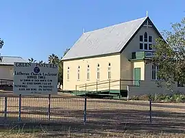 Green Pastures Lutheran Church, 2019 | |||||||||||||||
 Lockrose | |||||||||||||||
| Coordinates | 27.4937°S 152.4606°E | ||||||||||||||
| Population | 562 (2016 census)[1] | ||||||||||||||
| • Density | 35.80/km2 (92.7/sq mi) | ||||||||||||||
| Postcode(s) | 4342 | ||||||||||||||
| Area | 15.7 km2 (6.1 sq mi) | ||||||||||||||
| Time zone | AEST (UTC+10:00) | ||||||||||||||
| LGA(s) | |||||||||||||||
| State electorate(s) | Lockyer | ||||||||||||||
| Federal division(s) | Blair | ||||||||||||||
| |||||||||||||||
Geography
Lockrose is in South East Queensland. The northern boundary of Lockrose is marked by Lockyer Creek and the southern boundary by Brightview Road.[4]
Although not officially gazetted as a town, there is an established urban area in the centre of the locality where the school, church and other amenities are located and surrounded by housing. There is a second pocket of rural residential development in the south of the locality.[4]
Areas along the creek have been intensely farmed with irrigated crops with other rural land used for grazing on native vegetation.[4]
History
Lockrose Provisional School opened 20 March 1905. It became Lockrose State School on 1 January 1909.[5][6]
Green Pastures Lutheran Church opened in November 1909 under the leadership of Pastor Millat. There were approximately 350 people in attendance including the children at the school who were given a holiday so they could attend. It was described as the largest festival to have taken place in Lockrose. The wooden church was 30 by 20 feet (9.1 m × 6.1 m) and cost £136 (including fencing) and was free of debt at its opening.[7][8]
Lockrose Post Office opened by 1913 (a receiving office had been open from 1906) and closed in 1972.[9]
Lockrose had a population of 553 at the 2011 Census.[10]
Education
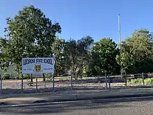
Lockrose State School is a government primary (Prep-6) school for boys and girls at 17 Zabel Road (27.4936°S 152.4601°E).[11][12] In 2017, the school had an enrolment of 64 students with 5 teachers and 9 non-teaching staff (5 full-time equivalent).[13]
There is no secondary school in Lockrose. The nearest secondary school is in Lowood, with others in Rosewood, Laidley and Gatton.[4]
Amenities
Services are held at the Green Pastures Lutheran Church in Zabel Road each Sunday.[14] There is a cemetery behind the church.[15]
References
- Australian Bureau of Statistics (27 June 2017). "Lockrose (SSC)". 2016 Census QuickStats. Retrieved 20 October 2018.
- "Lockrose – locality in Lockyer Valley Region (entry 44973)". Queensland Place Names. Queensland Government. Retrieved 11 June 2019.
- "Lockrose – locality in Somerset Region (entry 44883)". Queensland Place Names. Queensland Government. Retrieved 11 June 2019.
- "Queensland Globe". State of Queensland. Retrieved 24 August 2019.
- "Opening and closing dates of Queensland Schools". Queensland Government. Retrieved 18 April 2019.
- Queensland Family History Society (2010), Queensland schools past and present (Version 1.01 ed.), Queensland Family History Society, ISBN 978-1-921171-26-0
- "Lockrose Lutheran Church Opened". The Brisbane Courier. Vol. LXVI, no. 16, 173. Queensland, Australia. 11 November 1909. p. 4. Retrieved 25 August 2019 – via National Library of Australia.
- "Our Lockrose Letter". Queensland Times. Vol. LI, no. 7667. Queensland, Australia. 18 November 1909. p. 8 (DAILY). Retrieved 25 August 2019 – via National Library of Australia.
- Premier Postal History. "Post Office List". Premier Postal Auctions. Retrieved 10 May 2014.
- Australian Bureau of Statistics (31 October 2012). "Lockrose (State Suburb)". 2011 Census QuickStats. Retrieved 22 March 2014.
- "State and non-state school details". Queensland Government. 9 July 2018. Archived from the original on 21 November 2018. Retrieved 21 November 2018.
- "Lockrose State School". Retrieved 21 November 2018.
- "ACARA School Profile 2017". Archived from the original on 22 November 2018. Retrieved 22 November 2018.
- "Lutheran Church Lockrose Green Pastures Congregation, Qld". Lockrose Green Pastures Congregation, Qld. Retrieved 24 August 2019.
- "Lockrose Green Pastures Lutheran Cemetery, Laidley Shire". Archived from the original on 10 February 2017. Retrieved 25 August 2019.