Mount Scenery
Mount Scenery is an active volcano in the Caribbean Netherlands. Its lava dome forms the summit of the Saba island stratovolcano. At an elevation of 887 m (2,910 ft),[1] it is the highest point in both the Kingdom of the Netherlands, and, since the dissolution of the Netherlands Antilles on 10 October 2010, the highest point in the Netherlands proper.
| Mount Scenery | |
|---|---|
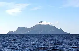 Saba with Mount Scenery's peak in the clouds | |
| Highest point | |
| Elevation | 887 m (2,910 ft) |
| Prominence | 887 m (2,910 ft) |
| Listing | Country high point |
| Coordinates | 17°38′06″N 63°14′21″W |
| Geography | |
 Mount Scenery location in the Lesser Antilles | |
| Location | Saba, Caribbean Netherlands |
| Geology | |
| Mountain type | Stratovolcano with lava dome |
| Volcanic arc | Lesser Antilles Volcanic Arc |
| Last eruption | 1640 |
The Saba volcano is potentially dangerous; the latest eruption was in or around the year 1640 and included explosions and pyroclastic flows.
On 2 September 2019, Mt. Scenery Nature Park was elevated to the status of national park.[2]
It has a hiking trail to its summit, which is one of Saba's biggest tourist attractions. Along the way up the mountain can be found all of the climate zones on Saba, including a cloud forest at the summit.
 The peak as seen from Windwardside
 Mount Scenery in the clouds
 View from Mount Scenery with Windwardside in the front
See also
- List of volcanoes in the Netherlands
- Vaalserberg - the highest point in the Netherlands in Europe
References
- "Saba". Global Volcanism Program. Smithsonian Institution. Retrieved 30 August 2020.
- "National park status for Mount Scenery Nature Park - Saba News". www.saba-news.com. Archived from the original on 2019-09-07.
| Populated places | |||
|---|---|---|---|
| Other locations | |||
| Transport | |||
| Education | |||
| Heraldry | |||
| Culture | |||