Portal:Tropical cyclones
The Tropical Cyclones Portal

A tropical cyclone is a storm system characterized by a large low-pressure center, a closed low-level circulation and a spiral arrangement of numerous thunderstorms that produce strong winds and heavy rainfall. Tropical cyclones feed on the heat released when moist air rises, resulting in condensation of water vapor contained in the moist air. They are fuelled by a different heat mechanism than other cyclonic windstorms such as nor'easters, European windstorms and polar lows, leading to their classification as "warm core" storm systems. Most tropical cyclones originate in the doldrums, approximately ten degrees from the Equator.
The term "tropical" refers to both the geographic origin of these systems, which form almost exclusively in tropical regions of the globe, as well as to their formation in maritime tropical air masses. The term "cyclone" refers to such storms' cyclonic nature, with anticlockwise rotation in the Northern Hemisphere and clockwise rotation in the Southern Hemisphere. Depending on its location and intensity, a tropical cyclone may be referred to by names such as "hurricane", "typhoon", "tropical storm", "cyclonic storm", "tropical depression" or simply "cyclone".
Selected named cyclone -
 Satellite image of the hurricane on September 9, 1971 |
Hurricane Edith was the strongest hurricane to form during the 1971 Atlantic hurricane season and formerly the southernmost landfalling Category 5 hurricane on record in the Atlantic until 2007. Edith also stands as one of the only Category 5 Atlantic hurricanes to not have its name retired, next to 1953's Hurricane Carol, 1961's Hurricane Esther, 2005's Hurricane Emily, and 2019's Hurricane Lorenzo. Edith developed from a tropical wave on September 5 and quickly strengthened into a hurricane in the Caribbean Sea. Edith rapidly intensified on September 9 and made landfall on Cape Gracias a Dios as a Category 5 hurricane on the Saffir-Simpson Hurricane Scale. Being a category 5 hurricane, Edith peaked at only 943 mbar (hPa), making Edith the least intense category 5 Atlantic hurricane on record. It quickly lost intensity over Central America and after briefly entering the Gulf of Honduras it crossed the Yucatán Peninsula in Mexico. After moving across the Gulf of Mexico a trough turned the storm to the northeast and Edith, after having restrengthened while accelerating towards the coast, made landfall on Louisiana with winds of 105 mph (169 km/h) on September 16. Edith steadily weakened over land and dissipated over Georgia on September 18.
The hurricane killed two people when it passed near Aruba. Striking northeastern Central America as a Category 5 hurricane, Edith destroyed hundreds of homes and killed at least 35 people. In Texas high tides caused coastal flooding but little damage. Edith caused moderate to heavy damage in portions of Louisiana due to flooding and a tornado outbreak from the storm. One tornado, rated F3 on the Fujita Scale, damaged several homes and injured multiple people in Baton Rouge. The tornado outbreak extended eastward into Florida, of which a few destroyed entire buildings. Damage in the United States totaled US$25 million (1971 dollars$, 167 million in 2021 dollars). (Full article...)Selected article -

The history of Atlantic tropical cyclone warnings details the progress of tropical cyclone warnings in the North Atlantic Ocean. The first service was set up in the 1870s from Cuba with the work of Father Benito Viñes. After his death, hurricane warning services were assumed by the US Army Signal Corps and United States Weather Bureau over the next few decades, first based in Jamaica and Cuba before shifting to Washington, D.C. The central office in Washington, which would evolve into the National Meteorological Center and the Weather Prediction Center, assumed the responsibilities by the early 20th century. This responsibility passed to regional hurricane offices in 1935, and the concept of the Atlantic hurricane season was established to keep a vigilant lookout for tropical cyclones during certain times of the year. Hurricane advisories issued every 12 hours by the regional hurricane offices began at this time.
The National Hurricane Center became a tropical cyclone warning center in 1956 and assumed many of the functions it has today by 1965. The National Hurricane Research Project, begun in the 1950s, used aircraft to study tropical cyclones and carry out experiments on mature hurricanes through its Stormfury project. Forecasts within the hurricane advisories were issued one day into the future in 1954 before being extended to two days into the future in 1961, three days into the future in 1964, and five days into the future in 2001. From the 1960s through the 1980s, work from the various regional hurricane offices was consolidated into the National Hurricane Center. Its name was changed to the Tropical Prediction Center in 1995, before reassuming its National Hurricane Center name in 2010. Tropical cyclone forecasting is done nowadays using statistical methods based on tropical cyclone climatology, as well as methods of numerical weather prediction where computers use mathematical equations of motion to determine their movement. (Full article...)Selected image -

Selected season -

The 2019 Atlantic hurricane season was the fourth consecutive above-average and damaging season dating back to 2016. However, many were weak and short-lived, especially towards the end of the season. Six of those named storms achieved hurricane status, while three intensified into major hurricanes. Two storms became Category 5 hurricanes, marking the fourth consecutive season with at least one Category 5 hurricane, the third consecutive season to feature at least one storm making landfall at Category 5 intensity, and the seventh on record to have multiple tropical cyclones reaching Category 5 strength. The season officially began on June 1 and ended on November 30. These dates historically describe the period each year when most tropical cyclones form in the Atlantic basin and are adopted by convention. However, tropical cyclogenesis is possible at any time of the year, as demonstrated by the formation of Subtropical Storm Andrea on May 20, making this the fifth consecutive year in which a tropical or subtropical cyclone developed outside of the official season.
The season's first hurricane, Barry, formed in mid-July in the northern Gulf of Mexico and struck Louisiana. Barry caused two deaths and produced flooding in Arkansas, Alabama, Louisiana, and Mississippi, with damage totaling about $600 million (2019 USD). Hurricane Dorian, the most intense tropical cyclone of the season, proved to be the costliest natural disaster in the history of the Bahamas, becoming the strongest hurricane to strike the country. Overall, Dorian caused about $5.1 billion in damage and 84 fatalities, mostly in the Bahamas. The 2019 season was the record fourth consecutive season to feature at least one Category 5 hurricane. Tropical Storm Fernand left flooding in Mexico, with approximately $11.3 million in damage and one death. Hurricane Humberto produced extensive damage in Bermuda, totaling at least $25 million. (Full article...)Related portals
Currently active tropical cyclones

Italicized basins are unofficial.
- North Atlantic (2023)
- No active systems
- East and Central Pacific (2023)
- No active systems
- West Pacific (2023)
- No active systems
- North Indian Ocean (2023)
- No active systems
- Mediterranean (2022–23)
- No active systems
- Australian region (2022–23)
- No active systems
- South Pacific (2022–23)
- No active systems
- South Atlantic (2022–23)
- No active systems
Last updated: 22:05, 15 May 2023 (UTC)
Tropical cyclone anniversaries

May 18
- 1986 - Cyclone Namu moved through the Solomon Islands, killing at least 111 people.
- 1997 - A powerful cyclone made landfall over in Bangladesh as a powerful Category 4 cyclone, killing more than 1,150 people.
- 2020 - Cyclone Amphan (pictured) reached peak intensity as a Category 5 super cyclonic storm, and two days later moved ashore near the border of India and Bangladesh. With an estimated US$13.7 billion in damages, Amphan was the costliest North Indian Ocean tropical cyclone on record.

May 19
- 1997 - A powerful cyclone (pictured) struck Bangladesh, killing 1,146 people.
- 2004 - A cyclone made landfall in Burma, causing floods and resulting in 236 fatalities.
- 2018 - Cyclone Sagar moved ashore Somaliland, with its associated floods killing 79 people across the region.

May 20
- 1989 - Typhoon Brenda makes landfall over Southern China as a Category 1 typhoon, killing about 84 people.
- 1999 - A powerful cyclone (pictured) struck southeastern Pakistan, killing at least 400 people, and perhaps as many as 6,000.
- 2005 - Tropical Depression Adrian became the first Pacific tropical cyclone to strike the Pacific coast of Honduras.
Did you know…


- …that the Joint Typhoon Warning Center considers that Typhoon Vera (pictured) of 1986 is actually two distinct systems, formed from two separated low-level circulations?
- …that Hurricane Agatha (pictured) was the strongest Pacific hurricane to make landfall in Mexico in May since records began in 1949?
- …that Cyclone Raquel (track pictured) travelled between the Australian and South Pacific basins between the 2014–15 and 2015–16 seasons, spanning both seasons in both basins?
- …that Cyclone Amphan (pictured) in 2020 was the first storm to be classified as a Super Cyclonic Storm in the Bay of Bengal since 1999?
General images -
 The number of $1 billion Atlantic hurricanes almost doubled from the 1980s to the 2010s, and inflation-adjusted costs have increased more than elevenfold. The increases have been attributed to climate change and to greater numbers of people moving to coastal areas. (from Effects of tropical cyclones)
.jpg.webp) Hurricane response involves working in hazardous conditions, including contamination and electrocution hazards from floodwater.
Hurricane response involves working in hazardous conditions, including contamination and electrocution hazards from floodwater. 2017 Atlantic hurricane season summary map (from Cyclone)
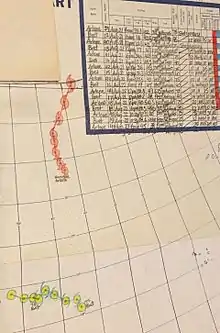 Chart with concurrent information for Hurricane Arlene and Tropical Storm Bret logged and plotted (from Tropical cyclone preparedness)
 Aerial image of destroyed houses in Tacloban, following Typhoon Haiyan (from Effects of tropical cyclones)
.jpg.webp) (from Cyclone)
(from Cyclone) Comparison between extratropical and tropical cyclones on surface analysis (from Cyclone)
 Radar image of Hurricane Erika making landfall over Northeastern Mexico (from Tropical cyclone observation)
 (from Cyclone)
 The aftermath of Hurricane Katrina in Gulfport, Mississippi. Katrina was the costliest tropical cyclone in United States history. (from Effects of tropical cyclones)
 The initial extratropical low-pressure area forms at the location of the red dot on the image. It is usually perpendicular (at a right angle to) the leaf-like cloud formation seen on satellite during the early stage of cyclogenesis. The location of the axis of the upper level jet stream is in light blue. (from Cyclone)
_(50).jpg.webp) Flooding in Port Arthur, Texas caused by Hurricane Harvey. Harvey was the wettest and second-costliest tropical cyclone in United States history. (from Effects of tropical cyclones)
Flooding in Port Arthur, Texas caused by Hurricane Harvey. Harvey was the wettest and second-costliest tropical cyclone in United States history. (from Effects of tropical cyclones) A fictitious synoptic chart of an extratropical cyclone affecting the UK and Ireland. The blue arrows between isobars indicate the direction of the wind, while the "L" symbol denotes the centre of the "low". Note the occluded, cold and warm frontal boundaries. (from Cyclone)
.jpg.webp) Personnel and equipment from the National Guard of the United States en route to Hurricane Florence response efforts in 2018
Personnel and equipment from the National Guard of the United States en route to Hurricane Florence response efforts in 2018 Hurricane Isabel (2003)'s effect on the North Carolina Outer Banks (from Effects of tropical cyclones)
 Tropical cyclones form when the energy released by the condensation of moisture in rising air causes a positive feedback loop over warm ocean waters. (from Cyclone)
 An extratropical cyclone near Iceland (from Cyclone)
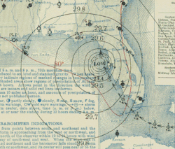 Surface weather map of the 1935 Labor Day hurricane moving up the west coast of Florida (from Tropical cyclone observation)
 (from Cyclone)
 All but the most expensive bottles of water were sold out at this Publix supermarket before Hurricane Irma; in the week preceding the storm, water sold out soon after shipments arrived (from Tropical cyclone preparedness)
 Broken concrete utility pole in Puerto Rico after Hurricane Maria in 2017, which ranks fourth in costliest US tropical cyclones. (from Effects of tropical cyclones)
 Environment (from Effects of tropical cyclones)
 Cyclone on Mars, imaged by the Hubble Space Telescope (from Cyclone)
.png.webp) (from Cyclone)
(from Cyclone)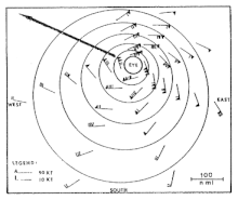 The dangerous semicircle is the upper-right corner, with the arrow marking the direction of motion of a Northern Hemisphere storm. Note that typhoons, etc. are asymmetrical, and semicircle is a convenient misnomer. (from Effects of tropical cyclones)
 A polar low over the Sea of Japan in December 2009 (from Cyclone)
 (from Cyclone)
 Hurricane Catarina, a rare South Atlantic tropical cyclone viewed from the International Space Station on March 26, 2004 (from Cyclone)
 An example of a chart for Matthew showing its five-day forecast track (from Tropical cyclone preparedness)
 Featured list -

The 2015 North Indian Ocean cyclone season was a below-average tropical cyclone season which featured the highest number of deaths since the 2010 season. Despite inactivity in the Bay of Bengal caused by the ongoing El Niño, the season produced an above-average number of tropical cyclones in the Arabian Sea. The first storm of the season, Ashobaa, formed on 7 June, while the final storm of the season, Megh, ultimately dissipated on 10 November.
A total of twelve depressions were recorded, of which nine intensified into deep depressions. Of these nine, a total of four further strengthened into cyclonic storms, while two attained their peaks as extremely severe cyclonic storms. In early June, Cyclonic Storm Ashobaa produced significant flooding in eastern Oman and the United Arab Emirates. Later that month, Deep Depression ARB 02 resulted in the worst floods in the Amreli district of Gujarat in 90 years. The storm resulted in 80 deaths and an estimated 16.5 billion Indian rupees in damage in the state. In late July and early August, Cyclonic Storm Komen resulted in between 187 and 280 deaths in northeastern India, Bangladesh and Myanmar due to torrential rains as it slowly moved through the region. In early November, Extremely Severe Cyclonic Storm Chapala, the strongest storm of the season, became the first recorded tropical cyclone to produce hurricane-force winds in Yemen. During the storm's passage, areas in southern Yemen received 610 mm (24 in) of rainfall over 48 hours, or 700% of the average yearly precipitation. Just days after Chapala produced widespread damage in Yemen and the Puntland region of Somalia, Extremely Severe Cyclonic Storm Megh passed through the same region causing further destruction. Megh was judged to have been the worst tropical cyclone ever to affect the Yemeni island of Socotra, and resulted in 18 deaths on the island. The final storm of the season to form, Deep Depression BOB 03, produced significant flooding in southern India and resulted in at least 71 deaths in the region in early November. (Full article...)Topics

Subcategories
Related WikiProjects
WikiProject Tropical cyclones is the central point of coordination for Wikipedia's coverage of tropical cyclones. Feel free to help!
WikiProject Weather is the main center point of coordination for Wikipedia's coverage of meteorology in general, and the parent project of WikiProject Tropical cyclones. Three other branches of WikiProject Weather in particular share significant overlaps with WikiProject Tropical cyclones:
- The Non-tropical storms task force coordinates most of Wikipedia's coverage on extratropical cyclones, which tropical cyclones often transition into near the end of their lifespan.
- The Floods task force takes on the scope of flooding events all over the world, with rainfall from tropical cyclones a significant factor in many of them.
- WikiProject Severe weather documents the effects of extreme weather such as tornadoes, which landfalling tropical cyclones can produce.
Things you can do
 |
Here are some tasks awaiting attention:
|
Wikimedia
The following Wikimedia Foundation sister projects provide more on this subject:
-
 Commons
Free media repository -
 Wikibooks
Free textbooks and manuals -
 Wikidata
Free knowledge base -
 Wikinews
Free-content news -
 Wikiquote
Collection of quotations -
 Wikisource
Free-content library -
 Wikiversity
Free learning tools -
 Wikivoyage
Free travel guide -
 Wiktionary
Dictionary and thesaurus
-
 List of all portalsList of all portals
 -
 The arts portal
 -
 Biography portal
 -
 Current events portal
 -
 Geography portal
 -
 History portal
 -
 Mathematics portal
 -
 Science portal
 -
 Society portal
 -
 Technology portal
 -
 Random portalRandom portal
 -
 WikiProject PortalsWikiProject Portals