Sefton, New Zealand
Sefton is a small town in the Waimakariri District, New Zealand, about 23 miles from Christchurch.[4]
Sefton | |
|---|---|
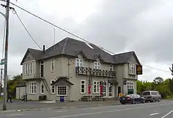 Anglers Arms Tavern in Sefton | |
| Coordinates: 43.247°S 172.667°E | |
| Country | New Zealand |
| Region | Canterbury |
| Territorial authority | Waimakariri District |
| Ward | Kaiapoi-Woodend Ward |
| Electorates | Kaikoura Te Tai Tonga (Maori electorate)[1] |
| Area | |
| • Total | 0.87 km2 (0.34 sq mi) |
| Population (2018)[3] | |
| • Total | 207 |
| • Density | 240/km2 (620/sq mi) |
| Time zone | UTC+12 (NZST) |
| • Summer (DST) | UTC+13 (NZDT) |
| Postcode | 7472 |
| Area code | 03 |
In 1886, it had a census population of 276 and was a station on the Christchurch Ashley line.[4] In 1891 it had a population of 390, of which 202 were male and 188 were female.[5] In the 2018 census, the population was 207.[3]
Education
Sefton has one school: Sefton School (est. 1884).[6] It is a decile 7 state non-integrated co-educational full primary, with 126 students (as of April 2023).[7] The principal is David Haythornthwaite.
Demographics
Sefton is defined by Statistics New Zealand as a rural settlement and covers 0.87 km2 (0.34 sq mi).[2] It is part of the wider Ashley-Sefton statistical area.[8]
| Year | Pop. | ±% p.a. |
|---|---|---|
| 2006 | 231 | — |
| 2013 | 225 | −0.38% |
| 2018 | 207 | −1.65% |
| Source: [3] | ||
Sefton had a population of 207 at the 2018 New Zealand census, a decrease of 18 people (-8.0%) since the 2013 census, and a decrease of 24 people (-10.4%) since the 2006 census. There were 84 households. There were 117 males and 93 females, giving a sex ratio of 1.26 males per female. The median age was 41.2 years (compared with 37.4 years nationally), with 45 people (21.7%) aged under 15 years, 27 (13.0%) aged 15 to 29, 102 (49.3%) aged 30 to 64, and 33 (15.9%) aged 65 or older.
Ethnicities were 95.7% European/Pākehā, 5.8% Māori, 2.9% Asian, and 2.9% other ethnicities (totals add to more than 100% since people could identify with multiple ethnicities).
Although some people objected to giving their religion, 65.2% had no religion, 26.1% were Christian and 2.9% were Muslim.
Of those at least 15 years old, 21 (13.0%) people had a bachelor or higher degree, and 51 (31.5%) people had no formal qualifications. The median income was $32,600, compared with $31,800 nationally. The employment status of those at least 15 was that 78 (48.1%) people were employed full-time, 36 (22.2%) were part-time, and 3 (1.9%) were unemployed.[3]
References
- Mapping elections.org.nz
- "ArcGIS Web Application". statsnz.maps.arcgis.com. Retrieved 30 August 2021.
- "Statistical area 1 dataset for 2018 Census". Statistics New Zealand. March 2020. 7023943.
- The Australian Handbook (incorporating New Zealand, Fiji, and New Guinea) Shippers, Importers and Professional Directory & Business Guide for ... Gordon and Gotch. 1888. pp. 516–.
- Dept, New Zealand. Registrar-General's (1892). Results of a Census of the Colony of New Zealand, Taken for the Night of the 5th April, 1891. Government Press. pp. 59–. Retrieved 23 May 2015.
- "Sefton School". Retrieved 24 May 2015.
- "New Zealand Schools Directory". New Zealand Ministry of Education. Retrieved 12 December 2022.
- 2018 Census place summary: Ashley-Sefton
External links
![]() Media related to Sefton, New Zealand at Wikimedia Commons
Media related to Sefton, New Zealand at Wikimedia Commons