Sokolov District
Sokolov District (Czech: okres Sokolov) is a district in the Karlovy Vary Region of the Czech Republic. Its capital is the town of Sokolov.
Sokolov District
Okres Sokolov | |
|---|---|
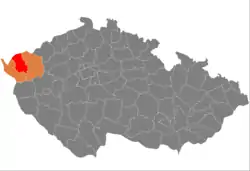 Location in the Karlovy Vary Region within the Czech Republic | |
| Coordinates: 50°13′N 12°38′E | |
| Country | |
| Region | Karlovy Vary |
| Capital | Sokolov |
| Area | |
| • Total | 753.72 km2 (291.01 sq mi) |
| Population (2022)[2] | |
| • Total | 85,200 |
| • Density | 110/km2 (290/sq mi) |
| Time zone | UTC+1 (CET) |
| • Summer (DST) | UTC+2 (CEST) |
| Municipalities | 38 |
| * Towns | 13 |
| * Market towns | 1 |
Administrative division
Sokolov District is divided into two administrative districts of municipalities with extended competence: Sokolov and Kraslice.
List of municipalities
Towns are marked in bold:
Březová - Bublava - Bukovany - Chlum Svaté Maří - Chodov - Citice - Dasnice - Dolní Nivy - Dolní Rychnov - Habartov - Horní Slavkov - Jindřichovice - Josefov - Kaceřov - Krajková - Královské Poříčí - Kraslice - Krásno - Kynšperk nad Ohří - Libavské Údolí - Loket - Lomnice - Nová Ves - Nové Sedlo - Oloví - Přebuz - Rotava - Rovná - Šabina - Šindelová - Sokolov - Staré Sedlo - Stříbrná - Svatava - Tatrovice - Těšovice - Vintířov - Vřesová
Geography
.jpg.webp)
Sokolov District borders Germany in the north. The terrain is characterized by two mountain ranges with a forested landscape, between which there is an unforested depression. The territory extends into five geomorphological mesoregions: Ore Mountains (north), Sokolov Basin (centre), Slavkov Forest (south), Cheb Basin (small part in the west) and Fichtel Mountains (very small part in the northwest). The highest point of the district is the mountain Špičák in Stříbrná with an elevation of 991 m (3,251 ft). The lowest point is the river bed of the Ohře in Loket at 374 m (1,227 ft).
The most important river is the Ohře, which flows across the district from west to east and drains the entire territory. Its longest tributary in the area is the Svatava. The Teplá River forms part of the southeastern district border. There are several water reservoirs and artificial lakes created by reclamation after coal mining. The largest body of water is Medard Lake.
There is one protected landscape area, located in the south of the district: Slavkovský les.
Demographics
|
|
| ||||||||||||||||||||||||||||||||||||||||||||||||||||||
| Source: Censuses[3][4] | ||||||||||||||||||||||||||||||||||||||||||||||||||||||||
Most populated municipalities
| Name | Population[2] | Area (km2) |
|---|---|---|
| Sokolov | 22,097 | 23 |
| Chodov | 12,683 | 14 |
| Kraslice | 6,537 | 81 |
| Horní Slavkov | 5,208 | 37 |
| Habartov | 4,687 | 21 |
| Kynšperk nad Ohří | 4,590 | 23 |
| Loket | 3,034 | 27 |
| Rotava | 2,809 | 12 |
| Březová | 2,616 | 60 |
| Nové Sedlo | 2,554 | 17 |
Economy
The largest employers with its headquarters in Sokolov District and at least 500 employers are:[5]
| Economic entity | Location | Number of employees | Activity |
|---|---|---|---|
| Sokolovská uhelná | Sokolov | 1,000–1,499 | Coal mining |
| SKF Lubrication Systems CZ | Chodov | 500–999 | Manufacture of lubrication systems |
Transport
The D6 motorway from Karlovy Vary to Cheb (part of the European routes E48 and E49) passes through the district.
Sights
.jpg.webp)
The most important monuments in the district, protected as national cultural monuments, are:[6]
- Jeroným Mine in Podstrání
- Artificial water channel Dlouhá stoka (partly)
- Pilgrimage area Chlum Svaté Maří with the Church of the Assumption of the Virgin Mary and Saint Mary Magdalene
The best-preserved settlements, protected as monument reservations and monument zones, are:[7]
- Loket (monument reservation)
- Horní Slavkov
- Dolní Rychnov
- Královské Poříčí
The most visited tourist destination is the Loket Castle.[8]
References
- "Small Lexicon of Municipalities of the Czech Republic – 2022". Czech Statistical Office. 2022-12-15.
- "Population of Municipalities – 1 January 2022". Czech Statistical Office. 2022-04-29.
- "Historický lexikon obcí České republiky 1869–2011 – Okres Sokolov" (in Czech). Czech Statistical Office. 2015-12-21. pp. 1–2.
- "Population Census 2021: Population by sex". Public Database. Czech Statistical Office. 2021-03-27.
- "Registr ekonomických subjektů". Business Register (in Czech). Czech Statistical Office. Retrieved 2023-02-23.
- "Výsledky vyhledávání: Národní kulturní památky, okres Sokolov". Ústřední seznam kulturních památek (in Czech). National Heritage Institute. Retrieved 2023-02-23.
- "Výsledky vyhledávání: Památkové rezervace, Památkové zóny, okres Sokolov". Ústřední seznam kulturních památek (in Czech). National Heritage Institute. Retrieved 2023-02-23.
- "Turisté mají v České republice nejraději zoologické zahrady, technické památky, koupání a Pražský hrad" (in Czech). CzechTourism. 2022-06-24. Retrieved 2023-02-23.
External links
- Sokolov District profile on the Czech Statistical Office's website