Waterlandkerkje
Waterlandkerkje is a village in the Dutch province of Zeeland. It is located in the municipality of Sluis.
Waterlandkerkje | |
|---|---|
Village | |
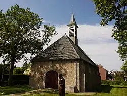 Dutch Reformed church of Waterlandkerkje | |
 Flag  Coat of arms | |
 Waterlandkerkje Location in the province of Zeeland in the Netherlands  Waterlandkerkje Waterlandkerkje (Netherlands) | |
| Coordinates: 51°19′3″N 3°33′14″E | |
| Country | Netherlands |
| Province | Zeeland |
| Municipality | Sluis |
| Area | |
| • Total | 17.25 km2 (6.66 sq mi) |
| Elevation | 2.3 m (7.5 ft) |
| Population (2021)[1] | |
| • Total | 480 |
| • Density | 28/km2 (72/sq mi) |
| Time zone | UTC+1 (CET) |
| • Summer (DST) | UTC+2 (CEST) |
| Postal code | 4508[1] |
| Dialing code | 0117 |
The village was first mentioned in 1740 as "de Kerk op Waterland, en doorgaans Nieuw of Klein Kerkje geheeten", and means "little church of Waterland". Waterland was a region which was flooded in 1375. The church was established around 1670 by Protestants who went to church in Waterland-Oudeman in the Spanish Netherlands (nowadays: Belgium), but who were removed by force by the Catholics.[3] The church originally stood in Waterland-Oudeman but was moved across the border. The church burned down in 1708, and was rebuilt in 1713.[4]
Waterlandkerkje was a separate municipality until 1970, when it was merged with Oostburg.[5] In 2003, it became part of the municipality of Sluis.[4]
Gallery
 Village house
 Welcome to Waterlandkerkje
References
- "Kerncijfers wijken en buurten 2021". Central Bureau of Statistics. Retrieved 21 April 2022.
- "Postcodetool for 4508AA". Actueel Hoogtebestand Nederland (in Dutch). Het Waterschapshuis. Retrieved 21 April 2022.
- "Waterlandkerkje - (geografische naam)". Etymologiebank (in Dutch). Retrieved 21 April 2022.
- "Waterlandkerkje". Plaatsengids (in Dutch). Retrieved 21 April 2022.
- Ad van der Meer and Onno Boonstra, Repertorium van Nederlandse gemeenten, KNAW, 2011.