Crenshaw County, Alabama
Crenshaw County is a county of the U.S. state of Alabama. As of 2010, 13,906 people lived there. Its county seat is Luverne.
Crenshaw County | |
|---|---|
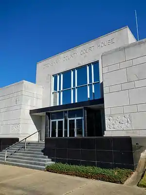
 Crenshaw County courthouse in Luverne | |
 Location within the U.S. state of Alabama | |
 Alabama's location within the U.S. | |
| Coordinates: 31°43′41″N 86°18′36″W | |
| Country | |
| State | |
| Founded | November 30, 1866 |
| Seat | Luverne |
| Largest city | Luverne |
| Area | |
| • Total | 610.88 sq mi (1,582.2 km2) |
| • Land | 609.58 sq mi (1,578.8 km2) |
| • Water | 1.30 sq mi (3.4 km2) 0.21%% |
| Population (2010) | |
| • Total | 13,906 |
| • Density | 23/sq mi (8.8/km2) |
History
Crenshaw County was formed from Butler, Coffee, Covington, Lowndes and Pike counties on November 30, 1866. Its name is in honor of a judge, Anderson Crenshaw.
Geography
According to the 2000 census, the county has a total area of 610.88 square miles (1,582.2 km2). 609.58 square miles (1,578.8 km2) (or 99.79%) is land and 1.30 square miles (3.4 km2) (or 0.21%) is water.[1] Much of the land is covered by forests that are used for logging.
Major highways
 U.S. Highway 29
 U.S. Highway 331
 State Route 10
 State Route 97
 State Route 106
Border counties
- Montgomery County (north)
- Pike County (east)
- Coffee County (southeast)
- Covington County (south)
- Butler County (west)
- Lowndes County (northwest)
References
- "Census 2000 U.S. Gazetteer Files: Counties". United States Census. Retrieved 2011-02-13.
This article is issued from Wikipedia. The text is licensed under Creative Commons - Attribution - Sharealike. Additional terms may apply for the media files.