Großheubach
Großheubach (or Grossheubach) is a market community in the Miltenberg district in the Lower Franconia region in Bavaria, Germany.
Großheubach | |
|---|---|
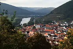 Großheubach, seen from Engelberg | |
 Coat of arms | |
Location of Großheubach within Miltenberg district  | |
 Großheubach  Großheubach | |
| Coordinates: 49°44′N 09°14′E | |
| Country | Germany |
| State | Bavaria |
| Admin. region | Unterfranken |
| District | Miltenberg |
| Government | |
| • Mayor (2020–26) | Gernot Winter[1] |
| Area | |
| • Total | 19.00 km2 (7.34 sq mi) |
| Elevation | 132 m (433 ft) |
| Population (2021-12-31)[2] | |
| • Total | 5,061 |
| • Density | 270/km2 (690/sq mi) |
| Time zone | UTC+01:00 (CET) |
| • Summer (DST) | UTC+02:00 (CEST) |
| Postal codes | 63920 |
| Dialling codes | 09371 |
| Vehicle registration | MIL |
| Website | www.grossheubach.de |
Geography
Place
Großheubach is on the right edge of the Main. The community is on the slopes of the Mittelgebirge Spessart. The highest point in the municipal area is the 439 m-high Ospisrain. Großheubach is on the Fränkischer Rotwein Wanderweg ("Franconian Red Wine Hiking Trail"). Across the Main are the hills of the Odenwald.
Subdivisions
The hamlets of Klotzenhof and Roßhof are part of the municipality Großheubach.
References
Other websites
 Media related to Großheubach at Wikimedia Commons
- Municipal website
Towns and municipalities in Miltenberg (district) | ||
|---|---|---|
| Coat of Arms of Miltenberg district | |
Authority control | |
|---|---|
| General | |
| National libraries | |
This article is issued from Wikipedia. The text is licensed under Creative Commons - Attribution - Sharealike. Additional terms may apply for the media files.