Montbenoît
Montbenoît is a commune. It is in Bourgogne-Franche-Comté in the Doubs department in east France.
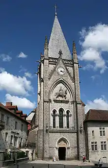
The abbey church (11th-20th centuries).
Montbenoît | |
|---|---|
.JPG.webp) The Doubs and the village | |
 Coat of arms | |
Location of Montbenoît 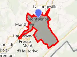 | |
 Montbenoît  Montbenoît | |
| Coordinates: 46°59′37″N 6°27′46″E | |
| Country | France |
| Region | Bourgogne-Franche-Comté |
| Department | Doubs |
| Arrondissement | Pontarlier |
| Canton | Ornans |
| Intercommunality | Montbenoît |
| Government | |
| • Mayor (2020–2026) | Lucien Benmehal |
| Area 1 | 5.03 km2 (1.94 sq mi) |
| Population | 399 |
| • Density | 79/km2 (210/sq mi) |
| Time zone | UTC+01:00 (CET) |
| • Summer (DST) | UTC+02:00 (CEST) |
| INSEE/Postal code | 25390 /25650 |
| Elevation | 762–1,125 m (2,500–3,691 ft) (avg. 790 m or 2,590 ft) |
| 1 French Land Register data, which excludes lakes, ponds, glaciers > 1 km2 (0.386 sq mi or 247 acres) and river estuaries. | |
References
- "Populations légales 2019". The National Institute of Statistics and Economic Studies. 29 December 2021.
Authority control | |
|---|---|
| General | |
| National libraries | |
This article is issued from Wikipedia. The text is licensed under Creative Commons - Attribution - Sharealike. Additional terms may apply for the media files.