Neunkirchen am Brand
Neunkirchen am Brand is a municipality in the district of Forchheim in Bavaria in Germany.
Neunkirchen am Brand | |
|---|---|
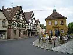 Center of Neunkirchen with timbered houses and the old deanery near St.-Michaels Church (right side of the image) | |
 Coat of arms | |
Location of Neunkirchen am Brand within Forchheim district  | |
 Neunkirchen am Brand  Neunkirchen am Brand | |
| Coordinates: 49°37′N 11°08′E | |
| Country | Germany |
| State | Bavaria |
| Admin. region | Oberfranken |
| District | Forchheim |
| Government | |
| • Mayor (2020–26) | Martin Walz[1] (CSU) |
| Area | |
| • Total | 26.37 km2 (10.18 sq mi) |
| Elevation | 317 m (1,040 ft) |
| Population (2021-12-31)[2] | |
| • Total | 8,140 |
| • Density | 310/km2 (800/sq mi) |
| Time zone | UTC+01:00 (CET) |
| • Summer (DST) | UTC+02:00 (CEST) |
| Postal codes | 91077 |
| Dialling codes | 09134 |
| Vehicle registration | FO |
| Website | www.neunkirchen-am-brand.de |
Districts
There are the following districts (pop. statistics as of December 31, 2006):
- Neunkirchen (5995 inhabitants)
- Baad (85 inhabitants)
- Ebersbach (250 inhabitants)
- Ermreuth (921 inhabitants)
- Großenbuch (575 inhabitants)
- Rödlas (149 inhabitants)
- Rosenbach (261 inhabitants)
- Gleisenhof (near Ermreuth) and Wellucken (7 inhabitants)
Furthermore, there the farms Vogelhof, Erleinhof and Saarmühle.
References
Other websites
Wikimedia Commons has media related to Neunkirchen am Brand.
Towns and municipalities in Forchheim (district) | ||
|---|---|---|
| Coat of Arms of Forchheim district | |
Authority control | |
|---|---|
| General | |
| National libraries | |
| Other | |
This article is issued from Wikipedia. The text is licensed under Creative Commons - Attribution - Sharealike. Additional terms may apply for the media files.