Neustadt am Main
Neustadt am Main (officially: Neustadt a. Main) is a community in the Main-Spessart district in the Regierungsbezirk of Lower Franconia (Unterfranken) in Bavaria, Germany and a member of the Verwaltungsgemeinschaft Lohr am Main (municipal administrative association).
Neustadt am Main | |
|---|---|
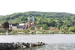 Neustadt with parish church | |
 Coat of arms | |
Location of Neustadt am Main within Main-Spessart district 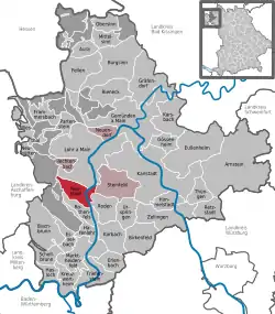 | |
 Neustadt am Main  Neustadt am Main | |
| Coordinates: 49°55′51″N 9°34′3″E | |
| Country | Germany |
| State | Bavaria |
| Admin. region | Unterfranken |
| District | Main-Spessart |
| Municipal assoc. | Lohr am Main |
| Government | |
| • Mayor (2020–26) | Stephan Morgenroth[1] |
| Area | |
| • Total | 19.81 km2 (7.65 sq mi) |
| Elevation | 150 m (490 ft) |
| Population (2021-12-31)[2] | |
| • Total | 1,249 |
| • Density | 63/km2 (160/sq mi) |
| Time zone | UTC+01:00 (CET) |
| • Summer (DST) | UTC+02:00 (CEST) |
| Postal codes | 97845 |
| Dialling codes | 09393 |
| Vehicle registration | MSP |
| Website | www.neustadt-erlach.de |
Geography
Location
Neustadt am Main is on both sides of the Main river in the Würzburg Region, around 8 km south of the town of Lohr at the foot of the Spessart hills. It is part of the Main-Spessart district in the Regierungsbezirk of Lower Franconia.
The municipal territory extends quite far into the wooded hills to the west. The highest peak of the Main-Spessart-Kreis is in Neustadt's territory: the Klosterkuppel at 552 m above sea level. In that area is the source of the Silberlochbach that flows into the Main near the town.
Out of a total municipal area of around 1,980 hectares, forest accounts for almost 1,600 ha.[3]
Subdivisions
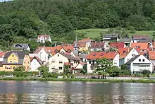
The community has the following Gemarkungen (traditional rural cadastral areas): Erlach am Main (on the left bank of the river), Neustadt am Main (on the right bank).[3] The two Ortsteile are linked by a pedestrian bridge across the Main (built 1970-71).[4]
There are two additional (small) settlements, Aurora and Margarethenhof, both located in the wooded hills west of the Main.
Neighbouring communities
From the north, clockwise:
- Lohr am Main
- Steinfeld
- Roden
- Marktheidenfeld
- Rothenfels
- Fürstlich Löwensteinscher Park (Gemeindefreies Gebiet)
- Forst Lohrerstraße (Gemeindefreies Gebiet)
References
- Liste der ersten Bürgermeister/Oberbürgermeister in kreisangehörigen Gemeinden, Bayerisches Landesamt für Statistik, 15 July 2021.
- "Tabelle 12411-003r Fortschreibung des Bevölkerungsstandes: Gemeinden, Stichtag" (in German). Bayerisches Landesamt für Statistik. June 2022.
- "Neustadt - Gemeinde (German)". Gemeinde Neustadt. Retrieved 28 May 2015.
- "Neustadt - Geschichte (German)". Verwaltungsgemeinschaft Lohr. Archived from the original on 28 May 2015. Retrieved 28 May 2015.
Other websites
- Neustadt-Erlach municipal website (in German)
- Verwaltungsgemeinschaft Lohr am Main website (in German)
- Kloster Neustadt (in German)
- History of Kloster Neustadt at Klöster in Bayern (Haus der Bayerischen Geschichte) (in German)
- Pfarreiengemeinschaft 12 Apostel am Tor zum Spessart (Roman Catholic parish) Archived 2022-01-04 at the Wayback Machine (in German)
- Neustadt and Erlach fire brigade (in German)
Authority control | |
|---|---|
| General | |
| National libraries | |