Oberstaufen
Oberstaufen is a municipality in the district of Oberallgäu in Schwaben, Bavaria, Germany. It is on the B 308 road from Lindau to Immenstadt.
Oberstaufen | |
|---|---|
 Saint Peter and Paul Church | |
 Coat of arms | |
Location of Oberstaufen within Oberallgäu district  | |
 Oberstaufen  Oberstaufen | |
| Coordinates: 47°33′N 10°1′E | |
| Country | Germany |
| State | Bavaria |
| Admin. region | Schwaben |
| District | Oberallgäu |
| Government | |
| • Mayor | Walter Grath |
| Area | |
| • Total | 125.84 km2 (48.59 sq mi) |
| Elevation | 791 m (2,595 ft) |
| Population (2021-12-31)[1] | |
| • Total | 7,814 |
| • Density | 62/km2 (160/sq mi) |
| Time zone | UTC+01:00 (CET) |
| • Summer (DST) | UTC+02:00 (CEST) |
| Postal codes | 87534 |
| Dialling codes | 08386 |
| Vehicle registration | OA |
| Website | www.oberstaufen.info |
History
It is first mentioned as Stoufun in AD 868.[2] It was originally part of Swabia. It joined Bavaria in 1805 with the Peace of Pressburg.
Oberstaufen was the first town in Germany to be on Google Street View.[3] This was because of a marketing campaign by the Oberstaufen tourist industry.
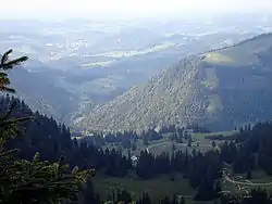
Oberstaufen from Nagelfluhkette mountains
References
- "Tabelle 12411-003r Fortschreibung des Bevölkerungsstandes: Gemeinden, Stichtag" (in German). Bayerisches Landesamt für Statistik. June 2022.
- "Gestern bis heute". oberstaufen.info. Archived from the original on May 16, 2017. Retrieved January 21, 2017.
- "Discover Oberstaufen with Google Street View". Oberstaufen Tourismus. Archived from the original on June 3, 2016. Retrieved January 21, 2017.
Other websites
- Webcams in Oberstaufen Archived 2017-02-22 at the Wayback Machine (in German)
- Fasnatziestag in Oberstaufen; YouTube
Authority control | |
|---|---|
| General | |
| National libraries | |
| Other | |
This article is issued from Wikipedia. The text is licensed under Creative Commons - Attribution - Sharealike. Additional terms may apply for the media files.