Pero, Lombardy
Pero (Milanese: Per / peːr) is a comune (municipality) in the Province of Milan in the Italian region Lombardy, located about 9 kilometres (6 mi) northwest of Milan.[3][4] As of 31 December 2004, it had a 10,378 people living there and an area of 5.0 square kilometres (1.9 sq mi).[5][6]
Pero
| |
|---|---|
| Comune di Pero | |
 Coat of arms | |
Location of Pero 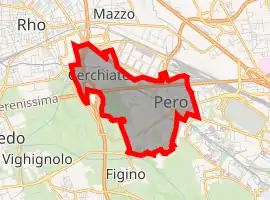 | |
 Pero Location of Pero in Italy  Pero Pero (Lombardy) | |
| Coordinates: 45°31′N 9°5′E | |
| Country | Italy |
| Region | Lombardy |
| Metropolitan city | Milan (MI) |
| Frazioni | Cerchiate, Cerchiarello |
| Area | |
| • Total | 5.0 km2 (1.9 sq mi) |
| Elevation | 144 m (472 ft) |
| Population (Dec. 2004)[2] | |
| • Total | 10,378 |
| • Density | 2,100/km2 (5,400/sq mi) |
| Demonym(s) | Peresi |
| Time zone | UTC+1 (CET) |
| • Summer (DST) | UTC+2 (CEST) |
| Postal code | 20016 |
| Dialing code | 02 |
| Website | Official website |
Demographics

References
- "Superficie di Comuni Province e Regioni italiane al 9 ottobre 2011". Italian National Institute of Statistics. Retrieved 16 March 2019.
- "Popolazione Residente al 1° Gennaio 2018". Italian National Institute of Statistics. Retrieved 16 March 2019.
- "Relation: Pero (45212)". OpenStreetMap. Retrieved 2022-07-18.
- "Pero · 20016 Pero, Metropolitan City of Milan, Italy". Pero · 20016 Pero, Metropolitan City of Milan, Italy. Retrieved 2022-07-18.
- All demographics and other statistics: Italian statistical institute Istat.
- "Statistiche demografiche Pero (MI) - Grafici su dati ISTAT". Tuttitalia.it (in Italian). Retrieved 2022-09-11.
This article is issued from Wikipedia. The text is licensed under Creative Commons - Attribution - Sharealike. Additional terms may apply for the media files.