Pleinfeld
Pleinfeld is a Franconian municipality and market town in Weißenburg-Gunzenhausen in Bavaria. It is in the Metropolitan Area of Nuremberg and in the Franconian Lake District.
Pleinfeld | |
|---|---|
 Pleinfeld town hall | |
 Coat of arms | |
Location of Pleinfeld within Weißenburg-Gunzenhausen district  | |
 Pleinfeld  Pleinfeld | |
| Coordinates: 49°6′N 10°58′E | |
| Country | Germany |
| State | Bavaria |
| Admin. region | Mittelfranken |
| District | Weißenburg-Gunzenhausen |
| Government | |
| • Mayor (2019–25) | Stefan Frühwald[1] (CSU) |
| Area | |
| • Total | 72.22 km2 (27.88 sq mi) |
| Elevation | 382 m (1,253 ft) |
| Population (2021-12-31)[2] | |
| • Total | 7,685 |
| • Density | 110/km2 (280/sq mi) |
| Time zone | UTC+01:00 (CET) |
| • Summer (DST) | UTC+02:00 (CEST) |
| Postal codes | 91785 |
| Dialling codes | 09144 |
| Vehicle registration | WUG |
| Website | www.pleinfeld.de |
Geography
Pleinfeld is in central Bavaria, in the south of the administrative region Middle Franconia. The municipal area borders on the neighbouring Bavarian district Roth. Neighbouring townships are Pfofeld, Ellingen, Ettenstatt, Höttingen, Absberg, Spalt, Heideck and Röttenbach. The landscape is hilly and forested.
Pleinfeld is on the rivers Swabian Rezat and Arbach, 8 kilometres (5.0 mi) north of Weißenburg in Bayern, and 45 kilometres (28 mi) south of Nuremberg. Other rivers in the municipality area are Brombach river and Banzerbach river, both tributary of the Swabian Rezat. The town's altitude is about 382 metres (1,253 feet) above sea level. The highest point of the municipality is near Dorsbrunn, 505 m (1,657 ft) asl. Pleinfeld is the biggest town at the Großer Brombachsee, a lake in the Franconian Lake District. Simultaneously, Pleinfeld is on the most Norther part of the Altmühl Valley Nature Park.
Administrative subdivisions
Pleinfeld has 35 subdivisions:[3]
- Allmannsdorf
- Banzermühle
- Birklein
- Böschleinsmühle
- Dorsbrunn
- Engelreuth
- Erlingsdorf
- Gündersbach
- Heinzenmühle
- Hohenweiler
- Kemnathen
- Ketschenmühle
- Kleinweingarten
- Langweidmühle
- Mackenmühle
- Mandlesmühle
- Mannholz
- Mäusleinsmühle
- Mischelbach
- Pleinfeld
- Prexelmühle
- Ramsberg am Brombachsee
- Regelsberg
- Reichertsmühle
- Roxfeld
- Sankt Veit
- Schloss Sandsee
- Seemannsmühle
- Stirn
- Utzenmühle
- Veitserlbach
- Walkerszell
- Walting
- Wurmmühle
Local Dialect
The local dialect of the region is East Franconian German, referred to in German as Fränkisch, with Pleinfeld being at the southern point of its extension. Traveling south, people speak Bavarian German and Alemannic German dialects.
Photogallery
 Lake
Lake Sandsee Castle
 Former train, now a playground
 Museum in Pleinfeld town center
 Church St. Nicholas
 Gate "Spalter Tor"
 historic city wall
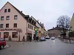 market square
 Saint Nepomuk Bridge
 timber-framed house "Zur Krone"
References
- Liste der ersten Bürgermeister/Oberbürgermeister in kreisangehörigen Gemeinden, Bayerisches Landesamt für Statistik, accessed 19 July 2021.
- "Tabelle 12411-003r Fortschreibung des Bevölkerungsstandes: Gemeinden, Stichtag" (in German). Bayerisches Landesamt für Statistik. June 2022.
- Bayerische Landesbibliothek Online
Other websites
 Media related to Pleinfeld at Wikimedia Commons
Towns and municipalities in Weißenburg-Gunzenhausen | ||
|---|---|---|