Silenen
Silenen is a municipality in the canton of Uri in Switzerland. It has an area of 144.78 square kilometres (55.90 square miles).
Silenen | |
|---|---|
 Coat of arms | |
Location of Silenen 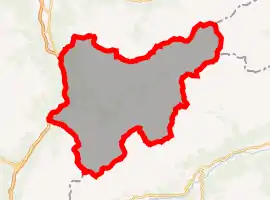 | |
 Silenen Silenen | |
| Coordinates: 46°47′N 8°40′E | |
| Country | Switzerland |
| Canton | Uri |
| District | n.a. |
| Area | |
| • Total | 144.78 km2 (55.90 sq mi) |
| Elevation | 510 m (1,670 ft) |
| Population (2018-12-31)[2] | |
| • Total | 1,949 |
| • Density | 13/km2 (35/sq mi) |
| Time zone | UTC+01:00 (Central European Time) |
| • Summer (DST) | UTC+02:00 (Central European Summer Time) |
| Postal code(s) | 6473 Silenen 6474 Amsteg 6475 Bristen |
| SFOS number | 1216 |
| Localities | Amsteg, Bristen, Dägerlohn, Dörfli, Maderanerthal, Ried, Rusli |
| Surrounded by | Disentis/Mustér (GR), Erstfeld, Gurtnellen, Linthal (GL), Schattdorf, Spiringen, Tujetsch (GR), Unterschächen |
| Website | www SFSO statistics |
Villages
Amsteg, Bristen, Dägerlohn, Dörfli, Maderanerthal, Ried and Rusli.
Gallery
 Silenen
 Meierturm Silenen
References
- "Arealstatistik Standard - Gemeinden nach 4 Hauptbereichen". Federal Statistical Office. Retrieved 13 January 2019.
- "Ständige Wohnbevölkerung nach Staatsangehörigkeitskategorie Geschlecht und Gemeinde; Provisorische Jahresergebnisse; 2018". Federal Statistical Office. 9 April 2019. Retrieved 11 April 2019.
This article is issued from Wikipedia. The text is licensed under Creative Commons - Attribution - Sharealike. Additional terms may apply for the media files.