Soda Springs, Idaho
Soda Springs is a city in Idaho in the United States. It is the county seat of Caribou County.[4] The population was 3,133 at the 2020 census.[5]
Soda Springs, Idaho | |
|---|---|
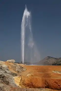 Eruption controlled geyser in Soda Springs | |
| Motto(s): "Historic Oregon Trail Oasis"[1] | |
 Location of Soda Springs in Caribou County, Idaho | |
 Soda Springs, Idaho Location in the United States | |
| Coordinates: 42°39′29″N 111°35′46″W | |
| Country | United States |
| State | Idaho |
| County | Caribou |
| Area | |
| • Total | 4.48 sq mi (11.59 km2) |
| • Land | 4.43 sq mi (11.47 km2) |
| • Water | 0.05 sq mi (0.12 km2) |
| Elevation | 5,774 ft (1,760 m) |
| Population | |
| • Total | 3,133 |
| • Density | 673.29/sq mi (259.98/km2) |
| Time zone | UTC-7 (Mountain (MST)) |
| • Summer (DST) | UTC-6 (MDT) |
| ZIP codes | 83230, 83276, 83285 |
| Area code(s) | 208 |
| FIPS code | 16-75195 |
| GNIS feature ID | 0400099 |
| Website | www |
History
This place was a good place to see on the Oregon Trail.
Geography
Climate
| Climate data for Soda Springs Airport | |||||||||||||
|---|---|---|---|---|---|---|---|---|---|---|---|---|---|
| Month | Jan | Feb | Mar | Apr | May | Jun | Jul | Aug | Sep | Oct | Nov | Dec | Year |
| Record high °F (°C) | 58 (14) |
56 (13) |
69 (21) |
80 (27) |
89 (32) |
97 (36) |
101 (38) |
98 (37) |
92 (33) |
85 (29) |
67 (19) |
57 (14) |
101 (38) |
| Average high °F (°C) | 28.6 (−1.9) |
32.2 (0.1) |
40.5 (4.7) |
52.3 (11.3) |
63.0 (17.2) |
73.9 (23.3) |
83.2 (28.4) |
81.8 (27.7) |
71.3 (21.8) |
58.1 (14.5) |
40.6 (4.8) |
30.2 (−1.0) |
54.6 (12.6) |
| Average low °F (°C) | 8.1 (−13.3) |
10.9 (−11.7) |
18.9 (−7.3) |
26.6 (−3.0) |
34.5 (1.4) |
40.7 (4.8) |
45.2 (7.3) |
44.1 (6.7) |
35.3 (1.8) |
26.3 (−3.2) |
18.3 (−7.6) |
8.1 (−13.3) |
26.4 (−3.1) |
| Record low °F (°C) | −37 (−38) |
−32 (−36) |
−19 (−28) |
−2 (−19) |
17 (−8) |
10 (−12) |
26 (−3) |
19 (−7) |
12 (−11) |
6 (−14) |
−25 (−32) |
−37 (−38) |
−37 (−38) |
| Average precipitation inches (mm) | 1.14 (29) |
1.27 (32) |
1.42 (36) |
1.35 (34) |
2.13 (54) |
1.36 (35) |
1.25 (32) |
1.31 (33) |
1.07 (27) |
1.26 (32) |
1.16 (29) |
1.03 (26) |
15.75 (399) |
| Source 1: NOAA (normals, 1971–2000)[6] | |||||||||||||
| Source 2: The Weather Channel (Records)[7] | |||||||||||||
People
| Historical population | |||
|---|---|---|---|
| Census | Pop. | %± | |
| 1900 | 428 | — | |
| 1910 | 501 | 17.1% | |
| 1920 | 935 | 86.6% | |
| 1930 | 831 | −11.1% | |
| 1940 | 1,087 | 30.8% | |
| 1950 | 1,329 | 22.3% | |
| 1960 | 2,424 | 82.4% | |
| 1970 | 2,977 | 22.8% | |
| 1980 | 4,051 | 36.1% | |
| 1990 | 3,111 | −23.2% | |
| 2000 | 3,381 | 8.7% | |
| 2010 | 3,058 | −9.6% | |
| 2020 | 3,133 | 2.5% | |
2010 Census
In 2010, there were 3,058 people, 1,204 households, and 830 families living in Soda Springs.[3] The people were 96.4% White, .1% African American, .3% Native American, .3% Asian, 0.4% Pacific Islander, 1.4% from other races, and 1.2% from two or more races. 3.4% of the people were Hispanic or Latino.
27.4% of the people were under 18 years old; 7.1% of the people were between 18 and 24 years old; 22.9% of the people were between 25 and 44 years old; 26.2% of the people were between 45 and 64 years old; 16.4% were 65 years old or older. 50.3% of the people were women, and 49.7% of the people were men.
References
- "Soda Springs, Idaho". Soda Springs, Idaho. Retrieved September 2, 2012.
- "2016 U.S. Gazetteer Files". United States Census Bureau. Retrieved Jul 26, 2017.
- "American FactFinder". United States Census Bureau. Retrieved 23 August 2015.
- "Find a County". National Association of Counties. Retrieved 23 August 2015.
- "Soda Springs city, Idaho".
- "Climatography of the United States NO.81" (PDF). National Oceanic and Atmospheric Administration. Archived from the original (PDF) on July 16, 2014. Retrieved January 16, 2011.
- "Monthly Averages for Soda Springs, ID". The Weather Channel. Archived from the original on October 23, 2012. Retrieved January 16, 2011.
