St. Marys, Kansas
St. Marys is a city in Pottawatomie and Wabaunsee counties in the U.S. state of Kansas.[6] As of the 2010 census, the city population was 2,627.[7]
Saint Marys, Kansas | |
|---|---|
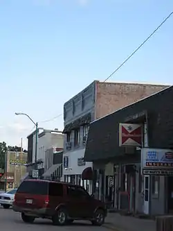 Downtown St. Marys (2009) | |
 Location within Pottawatomie County and Kansas | |
 KDOT map of Pottawatomie County (legend) | |
| Coordinates: 39°11′47″N 96°4′7″W | |
| Country | United States |
| State | Kansas |
| Counties | Pottawatomie, Wabaunsee[1] |
| Platted | 1866 |
| Incorporated | 1869 [2] |
| Named for | St. Mary's Mission |
| Government | |
| • Type | Mayor–Council |
| Area | |
| • Total | 1.18 sq mi (3.06 km2) |
| • Land | 1.18 sq mi (3.06 km2) |
| • Water | 0 sq mi (0 km2) |
| Elevation | 955 ft (291 m) |
| Population (2010) | |
| • Total | 2,627 |
| • Estimate (2018) | 2,636 |
| • Density | 2,200/sq mi (860/km2) |
| Time zone | UTC-6 (CST) |
| • Summer (DST) | UTC-5 (CDT) |
| ZIP code | 66536 [3] |
| Area code | 785 |
| FIPS code | 20-62400 [4] |
| GNIS ID | 0476443 [5] |
| Website | smks.info |
References
- "Subcounty population estimates: Kansas 2000-2007". United States Census Bureau, Population Division. 2009-03-18. Archived from the original (CSV) on 2009-03-31. Retrieved 2009-04-04.
- "City of St. Marys". The League of Kansas Municipalities. May 28, 2019.
- United States Postal Service (2012). "USPS - Look Up a ZIP Code". Retrieved 2012-02-15.
- "American FactFinder". United States Census Bureau. Retrieved 2008-01-31.
- "US Board on Geographic Names". United States Geological Survey. 2007-10-25. Retrieved 2008-01-31.
- "Geographic Names Information System". United States Geological Survey. Retrieved 2008-01-31.
- "2010 City Population and Housing Occupancy Status". U.S. Census Bureau. Retrieved December 2, 2011.
Municipalities and communities of Wabaunsee County, Kansas, United States | ||
|---|---|---|
| Cities |
|  Map of Kansas highlighting Wabaunsee County |
| Unincorporated communities |
| |
| Ghost towns |
| |
| Footnotes | ‡This populated place also has portions in an adjacent county or counties | |
| Authority control |
|---|
This article is issued from Wikipedia. The text is licensed under Creative Commons - Attribution - Sharealike. Additional terms may apply for the media files.