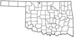
Burlington, Oklahoma
Burlington is a town in the U.S. state of Oklahoma. It is in Alfalfa County. As of the 2010 census, 152 people lived in this town.[3]
Burlington | |
|---|---|
 Location of Burlington, Oklahoma | |
 Burlington Location of Burlington, Oklahoma  Burlington Burlington (the United States) | |
| Coordinates: 36°54′00″N 98°25′22″W | |
| Country | United States |
| State | Oklahoma |
| County | Alfalfa |
| Area | |
| • Total | 0.28 sq mi (0.71 km2) |
| • Land | 0.28 sq mi (0.71 km2) |
| • Water | 0.00 sq mi (0.00 km2) |
| Elevation | 1,217 ft (371 m) |
| Population | |
| • Total | 152 |
| • Estimate (2018)[4] | 157 |
| • Density | 570.91/sq mi (220.59/km2) |
| Time zone | UTC-6 (Central (CST)) |
| • Summer (DST) | UTC-5 (CDT) |
| ZIP code | 73722[5] |
| Area code(s) | 580[5] |
| FIPS code | 40-10050[3][2] |
| GNIS feature ID | 1090717[2] |
The town is an agricultural center.
References
- "2018 U.S. Gazetteer Files". United States Census Bureau. Retrieved February 12, 2020.
- "Feature Detail Report for: Burlington". Geographic Names Information System(GNIS). United States Geological Survey. December 18, 1997. Retrieved July 1, 2016.
- "Geographic Identifiers: 2010 Demographic Profile Data (G001): Burlington town, Oklahoma". U.S. Census Bureau, American Factfinder. Retrieved July 15, 2013.
- "Population and Housing Unit Estimates". Retrieved June 4, 2019.
- "Burlington, Oklahoma". city-data.com. city-data.com. Retrieved May 13, 2016.
This article is issued from Wikipedia. The text is licensed under Creative Commons - Attribution - Sharealike. Additional terms may apply for the media files.
