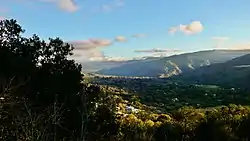
Carmel Valley Village, California
Carmel Valley Village (also known as Carmel Valley for short) is a census-designated place (CDP) in Monterey County, California.
Carmel Valley Village | |
|---|---|
 Carmel Valley, California | |
 Location in Monterey County and the state of California | |
 Carmel Valley Village Location in the United States | |
| Coordinates: 36°29′10″N 121°43′26″W | |
| Country | |
| State | |
| County | Monterey |
| Government | |
| • Board of Supervisors | Mary Adams (politician)[1] |
| • State senator | Bill Monning (D)[2] |
| • Assemblymember | Mark Stone (D)[2] |
| • U. S. rep. | Jimmy Panetta (D)[3] |
| Area | |
| • Total | 19.179 sq mi (49.673 km2) |
| • Land | 18.983 sq mi (49.166 km2) |
| • Water | 0.196 sq mi (0.507 km2) 1.02% |
| Elevation | 846 ft (258 m) |
| Population (2010) | |
| • Total | 4,407 |
| • Density | 230/sq mi (89/km2) |
| Time zone | UTC-8 (PST) |
| • Summer (DST) | UTC-7 (PDT) |
| ZIP code | 93924[6] |
| Area code(s) | 831 |
| FIPS code | 06-11324 |
| GNIS feature ID | 1867002 |
References
- Rahaim, Nick. "Mary Adams knocks Dave Potter off his longtime seat". Monterey County Weekly. Monterey County Weekly. Retrieved 30 June 2017.
- "Statewide Database". UC Regents. Archived from the original on February 1, 2015. Retrieved November 2, 2014.
- "California's 20th Congressional District - Representatives & District Map". Civic Impulse, LLC. Retrieved September 24, 2014.
- "2010 Census U.S. Gazetteer Files – Places – California". United States Census Bureau.
- "Carmel Valley Village". Geographic Names Information System. United States Geological Survey.
- "ZIP Code(tm) Lookup". United States Postal Service. Retrieved November 9, 2014.
Municipalities and communities of Monterey County, California, United States | ||
|---|---|---|
| Cities |  Monterey County map | |
| CDPs |
| |
| Unincorporated communities |
| |
| CCDs |
| |
| Ghost towns |
| |
| Footnotes | ‡This populated place also has portions in an adjacent county | |
This article is issued from Wikipedia. The text is licensed under Creative Commons - Attribution - Sharealike. Additional terms may apply for the media files.