Cedar Point, Kansas
Cedar Point is a city in Chase County, Kansas, United States. In 2010, 28 people lived there.[8] It is about 5 miles east of Florence and 0.5 miles south of U.S. Route 50 highway.
Cedar Point, Kansas | |
|---|---|
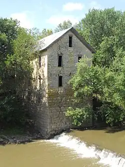 North side of 1875 Cedar Point Mill next to Cottonwood River (2012) | |
 Location within Chase County and Kansas | |
 KDOT map of Chase County (legend) | |
| Coordinates: 38°15′36″N 96°49′11″W[1] | |
| Country | United States |
| State | Kansas |
| County | Chase |
| Township | Cottonwood |
| Founded | 1862 |
| Incorporated | 1912 [2] |
| Government | |
| • Type | Mayor–Council |
| Area | |
| • Total | 0.07 sq mi (0.18 km2) |
| • Land | 0.07 sq mi (0.17 km2) |
| • Water | 0.00 sq mi (0.00 km2) |
| Elevation | 1,247 ft (380 m) |
| Population | |
| • Total | 28 |
| • Estimate (2019)[5] | 27 |
| • Density | 397.06/sq mi (154.40/km2) |
| Time zone | UTC-6 (CST) |
| • Summer (DST) | UTC-5 (CDT) |
| ZIP code | 66843 |
| Area code | 620 |
| FIPS code | 20-11425 [1][6] |
| GNIS ID | 477384 [1][7] |
History
In 1862, Cedar Point was created.[9] The first post office in Cedar Point was created in 1862.[10]
In 1867, a log dam was built across the Cottonwood River. A wooden-frame mill was built for sawing lumber. In 1868, it was changeded to grind flour. People named it Cedar Point Mill. In 1870, the name was changed to Drinkwater & Schriver Mill. In 1871, the current stone structure started being built. It finished in 1875. In 1884, the log dam was replaced by a stone dam.[11]
In 1871, the Atchison, Topeka and Santa Fe Railway built a railroad east-west and built a nearby station named Cedar Grove in the valley north of Cedar Point.[12] In 1996, it merged with Burlington Northern Railroad and renamed to the current BNSF Railway. Most locals still call this railroad as the "Santa Fe".
Geography
Cedar Point is at 38°15′39″N 96°49′18″W (38.260888, -96.821662),[13] in the Flint Hills of the Great Plains. The United States Census Bureau says that the city has a total area of 0.08 square miles (0.21 km2), all of it land.[14]
Area attractions
Cedar Point has two places on the National Register of Historic Places (NRHP).
People
| Historical population | |||
|---|---|---|---|
| Census | Pop. | %± | |
| 1880 | 113 | — | |
| 1920 | 190 | — | |
| 1930 | 141 | −25.8% | |
| 1940 | 140 | −0.7% | |
| 1950 | 107 | −23.6% | |
| 1960 | 87 | −18.7% | |
| 1970 | 73 | −16.1% | |
| 1980 | 66 | −9.6% | |
| 1990 | 39 | −40.9% | |
| 2000 | 53 | 35.9% | |
| 2010 | 28 | −47.2% | |
| 2019 (est.) | 27 | [5] | −3.6% |
| U.S. Decennial Census | |||
Cedar Point is part of the Emporia Micropolitan Statistical Area.
2010 census
The 2010 census[4] says there were 28 people, 13 households, and 5 families living in Cedar Point. The population density was 350.0 inhabitants per square mile (135.1/km2). There were 25 housing units at an average density of 312.5 per square mile (120.7/km2). 96.4% of the people were White and 3.6% of people were of two or more races.
There were 13 households, of which 23.1% had children under the age of 18 living with them, 30.8% were married couples living together, 7.7% had a male householder with no wife present, and 61.5% were not families. 46.2% of all households were made up of individuals, and 38.5% had someone living alone who was 65 years of age or older. The average household size was 2.15 and the average family size was 3.60.
The median age in Cedar Point was 51.5 years. 28.6% of residents were under the age of 18; 0% were between the ages of 18 and 24; 10.7% were from 25 to 44; 32% were from 45 to 64; and 28.6% were 65 years of age or older. 53.6% of the people were male, and 46.4% of the people were female.
Government
The Cedar Point government has a mayor and three council members. The council meets once per month.[2]
Education
Chase County USD 284 serves Cedar Point as the public school district. It has two schools.
- Chase County Junior/Senior High School, 600 Main St in Cottonwood Falls.
- Chase County Elementary School, 401 Maple St in Cottonwood Falls.
Cedar Point schools were closed through school unification. The Cedar Point High School mascot was Cedar Point Bronchos.[18]
Media
Newspapers
- Marion County Record, official newspaper for Marion County.
- Hillsboro Free Press, free newspaper for greater Marion County area.
Infrastructure
Transportation
U.S. Route 50 highway and BNSF Railway passes east-west near the city.
Utilities
- Internet
- Satellite is provided by HughesNet, StarBand, WildBlue.
- TV
- Satellite is provided by DirecTV, Dish Network.
- Terrestrial is provided by regional digital TV stations.
- Electricity
- Rural is provided by Butler REC.
- Trash is provided by City of Florence.
Related pages
- Cedar Township, Chase County, Kansas
- Fort Drinkwater
- National Register of Historic Places listings in Chase County, Kansas
- 1875 Cedar Point Mill (Drinkwater & Schriver Mill)
- 1916 Cottonwood River Pratt Truss Bridge
- Cottonwood River and Great Flood of 1951
- April 1956 tornado outbreak
References
- Geographic Names Information System (GNIS) details for Cedar Point, Kansas; United States Geological Survey (USGS); October 13, 1978.
- "City of Cedar Point". The League of Kansas Municipalities. May 26, 2019.
- "2019 U.S. Gazetteer Files". United States Census Bureau. Retrieved July 24, 2020.
- "U.S. Census website". United States Census Bureau. Retrieved 2012-07-06.
- "Population and Housing Unit Estimates". United States Census Bureau. May 24, 2020. Retrieved May 27, 2020.
- "U.S. Census website". United States Census Bureau. Retrieved 2008-01-31.
- "US Board on Geographic Names". United States Geological Survey. 2007-10-25. Retrieved 2008-01-31.
- "2010 City Population and Housing Occupancy Status". U.S. Census Bureau. Retrieved March 6, 2011.
- Kansas State Historical Society (1916). Biennial Report of the Board of Directors of the Kansas State Historical Society. Kansas State Printing Plant. pp. 154.
- "Kansas Post Offices, 1828-1961 (archived)". Kansas Historical Society. Archived from the original on October 9, 2013. Retrieved 5 June 2014.
- Mill History; Drinkwater & Schriver Mill Inc.
- Santa Fe Rail History
- "US Gazetteer files: 2010, 2000, and 1990". United States Census Bureau. 2011-02-12. Retrieved 2011-04-23.
- "US Gazetteer files 2010". United States Census Bureau. Archived from the original on 2012-01-25. Retrieved 2012-07-06.
- National Register of Historic Places - Cedar Point Mill
- Drinkwater & Schriver Flour Mill - Kansas Travel
- National Register of Historic Places - Cottonwood River Pratt Truss Bridge
- "Cedar Point Wins", The Emporia Gazette, 24 January 1946, p.12.
More reading
Other websites
- Cedar Point - Directory of Public Officials
- Chase County Chamber of Commerce
- Cedar Point - A "Quiet" town of Chase County, Kansas, History and photographs.
- Cedar Point Mill and Dam between 1900 and 1920
- Cedar Point City Map, KDOT
- Chase County Maps: Current, Historic, KDOT
Municipalities and communities of Chase County, Kansas, United States | ||
|---|---|---|
| Cities |
|  Map of Kansas highlighting Chase County |
| Unincorporated communities |
| |
| Ghost towns |
| |
| Townships |
| |
| Footnotes | ‡This populated place also has portions in an adjacent county or counties | |