Eching, Freising
Eching is a municipality in the district of Freising, in Upper Bavaria, Germany.
Eching | |
|---|---|
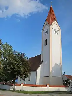 Church of Saint Andrew | |
.svg.png.webp) Coat of arms | |
Location of Eching within Freising district  | |
 Eching  Eching | |
| Coordinates: 48°18′N 11°37′E | |
| Country | Germany |
| State | Bavaria |
| Admin. region | Oberbayern |
| District | Freising |
| Subdivisions | 5 Orte |
| Government | |
| • Mayor (2020–26) | Sebastian Thaler[1] (Ind.) |
| Area | |
| • Total | 37.83 km2 (14.61 sq mi) |
| Elevation | 469 m (1,539 ft) |
| Population (2022-12-31)[2] | |
| • Total | 14,430 |
| • Density | 380/km2 (990/sq mi) |
| Time zone | UTC+01:00 (CET) |
| • Summer (DST) | UTC+02:00 (CEST) |
| Postal codes | 85386, 85379 |
| Dialling codes | 089, 08165, 08133 |
| Vehicle registration | FS |
| Website | www.eching.de |
Districts
The municipality Eching has existed since 1978 and consists of Eching, Günzenhausen, Ottenburg, Deutenhausen, Dietersheim and Gut Hollern. Hollern (to the west of the federal road B 13) has been incorporated with Unterschleißheim since 1990.
References
- Liste der ersten Bürgermeister/Oberbürgermeister in kreisangehörigen Gemeinden, Bayerisches Landesamt für Statistik, 15 July 2021.
- Genesis Online-Datenbank des Bayerischen Landesamtes für Statistik Tabelle 12411-003r Fortschreibung des Bevölkerungsstandes: Gemeinden, Stichtag (Einwohnerzahlen auf Grundlage des Zensus 2011) (Hilfe dazu).
Other websites
Wikimedia Commons has media related to Eching (Landkreis Freising).
Towns and municipalities in Freising (district) | ||
|---|---|---|
Coat of Arms of Freising district | ||
This article is issued from Wikipedia. The text is licensed under Creative Commons - Attribution - Sharealike. Additional terms may apply for the media files.