Los Indios, Texas
Los Indios is a town in Cameron County, Texas in the United States. The population was 1,083 at the 2010 census. It is close to the Mexico–United States border and is called a border town because of it.
Los Indios, Texas | |
|---|---|
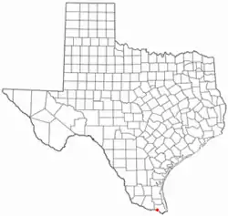
 Location of Los Indios, Texas | |
 | |
| Coordinates: 26°2′59″N 97°44′25″W | |
| Country | United States |
| State | Texas |
| County | Cameron |
| Founded | 1913 |
| Area | |
| • Total | 1.88 sq mi (4.88 km2) |
| • Land | 1.88 sq mi (4.86 km2) |
| • Water | 0.01 sq mi (0.02 km2) |
| Elevation | 56 ft (17 m) |
| Population (2010) | |
| • Total | 1,083 |
| • Estimate (2019) | 1,060 |
| • Density | 565.33/sq mi (218.26/km2) |
| Time zone | UTC-6 (Central (CST)) |
| • Summer (DST) | UTC-5 (CDT) |
| ZIP code | 78567 |
| Area code(s) | 956 |
| FIPS code | 48-44128[2] |
| GNIS feature ID | 1374728[3] |
References
- "2019 U.S. Gazetteer Files". United States Census Bureau. Retrieved August 7, 2020.
- "U.S. Census website". United States Census Bureau. Retrieved 2008-01-31.
- "US Board on Geographic Names". United States Geological Survey. 2007-10-25. Retrieved 2008-01-31.
This article is issued from Wikipedia. The text is licensed under Creative Commons - Attribution - Sharealike. Additional terms may apply for the media files.
