Mystic, Connecticut
Mystic is a U.S. village and census-designated place (CDP) in Groton and Stonington, Connecticut. Mystic has no independent government because it is not a municipality in the state of Connecticut.
Mystic | |
|---|---|
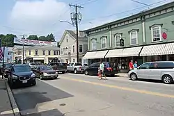 Main Street, downtown Mystic | |
 Mystic Location within the state of Connecticut | |
| Coordinates: 41°21′15″N 71°57′59″W | |
| Country | United States |
| State | Connecticut |
| County | New London |
| Area | |
| • Total | 3.8 sq mi (9.8 km2) |
| • Land | 3.4 sq mi (8.7 km2) |
| • Water | 0.4 sq mi (1.1 km2) |
| Elevation | 10 ft (3 m) |
| Population (2010) | |
| • Total | 4,205 |
| • Density | 1,100/sq mi (430/km2) |
| Time zone | UTC−5 (Eastern (EST)) |
| • Summer (DST) | UTC−4 (EDT) |
| ZIP codes | 06355, 06372, 06388 |
| Area code | 860 |
| FIPS code | 09-49810 |
| GNIS feature ID | 209165[1] |
Historically, Mystic was a leading seaport of the area. The story of Mystic's nautical background is told at Mystic Seaport, the nation's largest maritime museum,[2] which has preserved a number of sailing ships, such as the whaling ship Charles W. Morgan. The village is located on the Mystic River, which flows into Long Island Sound, giving access to the sea. The Mystic River Bascule Bridge crosses the river in the center of the village. According to the Mystic River Historical Society, the name "Mystic" comes from the Pequot words "missi-tuk" as describing a large river whose waters are driven into waves by tides or wind. The population was 4,205 at the 2010 census.[3]
References
- U.S. Geological Survey Geographic Names Information System: Mystic
- "About Mystic Seaport Museum".
- "Profile of General Population and Housing Characteristics: 2010 Demographic Profile Data (DP-1): Mystic CDP, Connecticut". U.S. Census Bureau, American Factfinder. Retrieved October 29, 2012.
Municipalities and communities of New London County, Connecticut, United States | ||
|---|---|---|
| Cities |  | |
| Towns | ||
| Boroughs |
| |
| CDPs |
| |
| Other communities |
| |
| Indian reservations |
| |
| Footnotes | ‡This populated place also has portions in an adjacent county or counties | |