Reisbach (Vils)
Reisbach is a market town in Bavaria. It is on the Vils River, and belongs to the administrative region of Lower Bavaria.
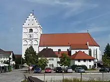
Church of St. Michael
Reisbach | |
|---|---|
 Town hall | |
.svg.png.webp) Coat of arms | |
Location of Reisbach within Dingolfing-Landau district  | |
 Reisbach  Reisbach | |
| Coordinates: 48°34′N 12°38′E | |
| Country | Germany |
| State | Bavaria |
| Admin. region | Niederbayern |
| District | Dingolfing-Landau |
| Subdivisions | 7 Ortsteile |
| Government | |
| • Mayor (2020–26) | Rolf-Peter Holzleitner [1] (FW) |
| Area | |
| • Total | 94.16 km2 (36.36 sq mi) |
| Elevation | 408 m (1,339 ft) |
| Population (2022-12-31)[2] | |
| • Total | 7,894 |
| • Density | 84/km2 (220/sq mi) |
| Time zone | UTC+01:00 (CET) |
| • Summer (DST) | UTC+02:00 (CEST) |
| Postal codes | 94419 |
| Dialling codes | 08734 08735 (Bachham) |
| Vehicle registration | DGF |
| Website | www |
Neighbouring communities
The neighbouring communities, listed clockwise, are Mamming, Landau an der Isar, Simbach (bei Landau), Falkenberg (Niederbayern), Rimbach (Niederbayern), Gangkofen, Marklkofen and Gottfrieding.
Villages in the municipality
- Englmannsberg
- Griesbach
- Niederhausen
- Oberhausen
- Obermünchsdorf
- Reith
- Thannenmais
References
- Liste der ersten Bürgermeister/Oberbürgermeister in kreisangehörigen Gemeinden, Bayerisches Landesamt für Statistik, 15 July 2021.
- Genesis Online-Datenbank des Bayerischen Landesamtes für Statistik Tabelle 12411-003r Fortschreibung des Bevölkerungsstandes: Gemeinden, Stichtag (Einwohnerzahlen auf Grundlage des Zensus 2011) (Hilfe dazu).
Places next to Reisbach (Vils) | ||||||||||
|---|---|---|---|---|---|---|---|---|---|---|
| ||||||||||
This article is issued from Wikipedia. The text is licensed under Creative Commons - Attribution - Sharealike. Additional terms may apply for the media files.