Salisbury, Connecticut
Salisbury is a town in Litchfield County, Connecticut, United States. The town is the most northwest in the State of Connecticut. The MA-NY-CT (Massachusetts-New York-Connecticut) Tri-State Marker is just on the border of Salisbury. The population was 3,977 at the 2000 census.
Salisbury, Connecticut | |
|---|---|
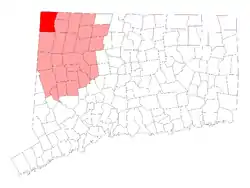 Location in Litchfield County, Connecticut | |
| Coordinates: 41°59′06″N 73°25′20″W | |
| Country | |
| U.S. state | |
| County | Litchfield |
| Region | Northwest Hills |
| Established / Incorporated | 1741 |
| Government | |
| • Type | Selectman-town meeting |
| • First selectman | Curtis G. Rand (D) |
| • Selectman | James van B. Dresser (D) |
| • Selectman | Katherine Kiefer (I) |
| Area | |
| • Total | 60.1 sq mi (155.7 km2) |
| • Land | 57.3 sq mi (148.5 km2) |
| • Water | 2.8 sq mi (7.1 km2) |
| Elevation | 699 ft (213 m) |
| Population (2000) | |
| • Total | 3,977 |
| • Density | 71/sq mi (28/km2) |
| Time zone | UTC-5 (Eastern) |
| • Summer (DST) | UTC-4 (Eastern) |
| ZIP code | 06039, 06068 06079 |
| Area code(s) | 860 |
| FIPS code | 09-66420 |
| GNIS feature ID | 0213500 |
| Website | salisburyct |
Scoville Library in Salisbury was the first in the United States to be open to the public free of charge.[1]
Although the peak of Mount Frissell is in Massachusetts, the south slope of the mountain is in Salisbury. It is the highest point in Connecticut. In Salisbury there are several ponds and six lakes: Wononscopomuc, Washinee, Washining, Wononpakook, Riga Lake and South Pond. The Appalachian Trail runs through Salisbury.
References
Municipalities and communities of Litchfield County, Connecticut, United States | ||
|---|---|---|
| Consolidated city |  | |
| Towns | ||
| Boroughs |
| |
| CDPs |
| |
| Other communities |
| |
| Indian reservation |
| |
| Footnotes | ‡This populated place also has portions in an adjacent county or counties. | |
This article is issued from Wikipedia. The text is licensed under Creative Commons - Attribution - Sharealike. Additional terms may apply for the media files.