Scott County, Mississippi
Scott County is a county in the U.S. state of Mississippi. As of the 2010 census, 28,264 people lived there.[1] Its county seat is Forest.[2]
Scott County | |
|---|---|
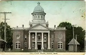 1900 Scott County Courthouse (replaced 1924 and again in 1955) | |
 Location within the U.S. state of Mississippi | |
 Mississippi's location within the U.S. | |
| Coordinates: 32°24′N 89°33′W | |
| Country | |
| State | |
| Founded | December 23, 1833 |
| Named for | Abram M. Scott |
| Seat | Forest |
| Largest city | Forest |
| Area | |
| • Total | 610 sq mi (1,600 km2) |
| • Land | 609 sq mi (1,580 km2) |
| • Water | 1.2 sq mi (3 km2) 0.2% |
| Population (2010) | |
| • Total | 28,264 |
| • Estimate (2018) | 28,287 |
| • Density | 46/sq mi (18/km2) |
| Time zone | UTC−6 (Central) |
| • Summer (DST) | UTC−5 (CDT) |
| Congressional district | 3rd |
| Website | www |
Geography
According to the U.S. Census Bureau says that the county has a total area of 610 square miles (1,600 km2). Of that 609 square miles (1,580 km2) is land and 1.2 square miles (3.1 km2) (0.2%) is water.[3]
It is an about 45 minute driving distance from Jackson.[4]
Major highways
 Interstate 20
 U.S. Highway 80
 Mississippi Highway 13
 Mississippi Highway 21
 Mississippi Highway 35
Bordering counties
- Leake County (north)
- Newton County (east)
- Smith County (south)
- Rankin County (west)
- Madison County (northwest)
National protected area
- Bienville National Forest (part)
History
Scott County was created on December 23, 1833. It is named for Abram M. Scott, the Governor of Mississippi from 1832 to 1833.
Demographics
| Historical population | |||
|---|---|---|---|
| Census | Pop. | %± | |
| 1840 | 1,653 | — | |
| 1850 | 3,961 | 139.6% | |
| 1860 | 8,139 | 105.5% | |
| 1870 | 7,847 | −3.6% | |
| 1880 | 10,845 | 38.2% | |
| 1890 | 11,740 | 8.3% | |
| 1900 | 14,316 | 21.9% | |
| 1910 | 16,723 | 16.8% | |
| 1920 | 16,420 | −1.8% | |
| 1930 | 20,914 | 27.4% | |
| 1940 | 23,144 | 10.7% | |
| 1950 | 21,681 | −6.3% | |
| 1960 | 21,187 | −2.3% | |
| 1970 | 21,369 | 0.9% | |
| 1980 | 24,556 | 14.9% | |
| 1990 | 24,137 | −1.7% | |
| 2000 | 28,423 | 17.8% | |
| 2010 | 28,264 | −0.6% | |
| 2018 (est.) | 28,287 | [5] | 0.1% |
| U.S. Decennial Census[6] 1790-1960[7] 1900-1990[8] 1990-2000[9] 2010-2013[1] | |||
As of the 2010 census says that there were 28,264 people, 10,248 households, and 7,264 families living in the county.[10]
Communities
Towns
- Lake (partly in Newton County)
- Sebastopol (partly in Leake County)
Census-designated places
- Hillsboro
Other unincorporated communities
- Forkville
- Harperville
- Homewood
- Kalem
- Ludlow
- Midway
- Norris
- Pulaski
References
- "State & County QuickFacts". United States Census Bureau. Archived from the original on September 5, 2015. Retrieved September 5, 2013.
- "Find a County". National Association of Counties. Retrieved 2011-06-07.
- "2010 Census Gazetteer Files". United States Census Bureau. August 22, 2012. Archived from the original on September 28, 2013. Retrieved November 7, 2014.
- Robertson, Campbell. "In a Mississippi Jail, Convictions and Counsel Appear Optional." The New York Times. September 24, 2014. Print: September 25, 2014, p. A15 ("In a Mississippi Jail, Convictions and Counsel Appear Optional"). Retrieved on September 26, 2014.
- "Population and Housing Unit Estimates". Retrieved November 8, 2019.
- "U.S. Decennial Census". United States Census Bureau. Retrieved November 7, 2014.
- "Historical Census Browser". University of Virginia Library. Retrieved November 7, 2014.
- "Population of Counties by Decennial Census: 1900 to 1990". United States Census Bureau. Retrieved November 7, 2014.
- "Census 2000 PHC-T-4. Ranking Tables for Counties: 1990 and 2000" (PDF). United States Census Bureau. Retrieved November 7, 2014.
- Bureau, U.S. Census. "American FactFinder - Results". factfinder2.census.gov. Retrieved 2018-03-04.
Other websites
Wikimedia Commons has media related to Scott County, Mississippi.
Places next to Scott County, Mississippi | ||||||||||
|---|---|---|---|---|---|---|---|---|---|---|
| ||||||||||
Municipalities and communities of Scott County, Mississippi, United States | ||
|---|---|---|
| Cities | Map of Mississippi highlighting Scott County | |
| Towns | ||
| CDPs |
| |
| Other communities |
| |
| Indian reservation |
| |
| Footnotes | ‡This populated place also has portions in an adjacent county or counties | |
This article is issued from Wikipedia. The text is licensed under Creative Commons - Attribution - Sharealike. Additional terms may apply for the media files.