Wayland, Massachusetts
Wayland, Massachusetts is a town in Massachusetts, United States. As of 2010, there were 12,994 residents. [1]
Wayland, Massachusetts | |
|---|---|
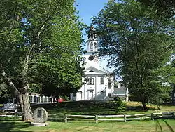
 First Parish in Wayland | |
 Location in Middlesex County in Massachusetts | |
| Coordinates: 42°21′45″N 71°21′43″W | |
| Country | United States |
| State | Massachusetts |
| County | Middlesex |
| Settled | 1638 |
| Incorporated | 1780 |
| Government | |
| • Type | Open town meeting |
| Area | |
| • Total | 15.9 sq mi (41.2 km2) |
| • Land | 15.2 sq mi (39.4 km2) |
| • Water | 0.7 sq mi (1.7 km2) |
| Elevation | 127 ft (39 m) |
| Population (2010) | |
| • Total | 12,994 |
| • Density | 820/sq mi (320/km2) |
| Time zone | UTC-5 (Eastern) |
| • Summer (DST) | UTC-4 (Eastern) |
| ZIP code | 01778 |
| Area code(s) | 508/774 |
| FIPS code | 25-73790 |
| GNIS feature ID | 0618243 |
| Website | http://www.wayland.ma.us/ |
This article is issued from Wikipedia. The text is licensed under Creative Commons - Attribution - Sharealike. Additional terms may apply for the media files.
