Westmoreland, Kansas
Westmoreland is a city in Pottawatomie County, Kansas, United States.[6] It is also the county seat of Pottawatomie County. In 2010, 778 people lived there.[7]
Westmoreland, Kansas | |
|---|---|
City and County seat | |
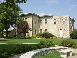 Pottawatomie County Court House (2009) | |
 Location within Pottawatomie County and Kansas | |
 KDOT map of Pottawatomie County (legend) | |
| Coordinates: 39°23′41″N 96°24′51″W | |
| Country | United States |
| State | Kansas |
| County | Pottawatomie |
| Platted | 1871 |
| Incorporated | 1884 |
| Named for | Westmoreland County, Pennsylvania |
| Area | |
| • Total | 0.52 sq mi (1.35 km2) |
| • Land | 0.52 sq mi (1.35 km2) |
| • Water | 0 sq mi (0 km2) |
| Elevation | 1,201 ft (366 m) |
| Population | |
| • Total | 778 |
| • Estimate (2016)[3] | 769 |
| • Density | 1,500/sq mi (580/km2) |
| Time zone | UTC-6 (CST) |
| • Summer (DST) | UTC-5 (CDT) |
| ZIP codes | 66426, 66549 |
| Area code | 785 |
| FIPS code | 20-77200 [4] |
| GNIS ID | 0476096 [5] |
| Website | cityofwestmorelandks.org |
History
Westmoreland was platted in 1871.[8] It was named after Westmoreland County, Pennsylvania.[9]
Geography
Westmoreland is at 39°23′41″N 96°24′51″W (39.394770, -96.414154).[10] The United States Census Bureau says that the city has a total area of 0.52 square miles (1.35 km2). All of it is land.[1]
People
| Historical population | |||
|---|---|---|---|
| Census | Pop. | %± | |
| 1890 | 478 | — | |
| 1900 | 620 | 29.7% | |
| 1910 | 484 | −21.9% | |
| 1920 | 386 | −20.2% | |
| 1930 | 501 | 29.8% | |
| 1940 | 532 | 6.2% | |
| 1950 | 416 | −21.8% | |
| 1960 | 460 | 10.6% | |
| 1970 | 485 | 5.4% | |
| 1980 | 598 | 23.3% | |
| 1990 | 541 | −9.5% | |
| 2000 | 631 | 16.6% | |
| 2010 | 778 | 23.3% | |
| 2016 (est.) | 769 | [3] | −1.2% |
| U.S. Decennial Census | |||
Westmoreland is part of the Manhattan, Kansas Metropolitan Statistical Area.
Famous people
- Benjamin Butler, painter
- Billie Moore, basketball coach, member of the Basketball Hall of Fame
- Frank Wiziarde, better known as "Whizzo the Clown"
References
- "US Gazetteer files 2010". United States Census Bureau. Archived from the original on 2012-07-02. Retrieved 2012-07-06.
- "American FactFinder". United States Census Bureau. Retrieved 2012-07-06.
- "Population and Housing Unit Estimates". Retrieved June 9, 2017.
- "American FactFinder". United States Census Bureau. Retrieved 2008-01-31.
- "US Board on Geographic Names". United States Geological Survey. 2007-10-25. Retrieved 2008-01-31.
- "Find a County". National Association of Counties. Retrieved 2011-06-07.
- "2010 City Population and Housing Occupancy Status". U.S. Census Bureau. Retrieved March 27, 2011.
- Blackmar, Frank Wilson (1912). Kansas: A Cyclopedia of State History, Volume 2. Standard Publishing Company. p. 902.
- Kansas State Historical Society (1916). Biennial Report of the Board of Directors of the Kansas State Historical Society. Kansas State Printing Plant. p. 262.
- "US Gazetteer files: 2010, 2000, and 1990". United States Census Bureau. 2011-02-12. Retrieved 2011-04-23.
Other websites
- City
- Schools
- USD 323 Archived 2019-07-17 at the Wayback Machine, local school district
- Westmoreland Elementary School Archived 2019-10-18 at the Wayback Machine
- Maps
- Westmoreland City Map, KDOT
Municipalities and communities of Pottawatomie County, Kansas, United States | ||
|---|---|---|
| Cities |
|  Map of Kansas highlighting Pottawatomie County |
| Unincorporated communities |
| |
| Footnotes | ‡This populated place also has portions in an adjacent county or counties | |
This article is issued from Wikipedia. The text is licensed under Creative Commons - Attribution - Sharealike. Additional terms may apply for the media files.