Woodstock (village), Vermont
Woodstock is an incorporated village located within the town of Woodstock in Windsor County, Vermont, United States. As of the 2010 census, the village population was 900.[5]
Woodstock, Vermont | |
|---|---|
Village | |
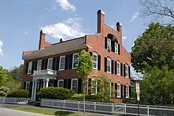 General Lyman Mower House on the Green | |
_highlighted.svg.png.webp) Location in Windsor County and the state of Vermont. | |
| Coordinates: 43°37′25″N 72°31′2″W | |
| Country | United States |
| State | Vermont |
| County | Windsor |
| Area | |
| • Total | 1.03 sq mi (2.67 km2) |
| • Land | 1.00 sq mi (2.58 km2) |
| • Water | 0.03 sq mi (0.09 km2) |
| Elevation | 702 ft (214 m) |
| Population (2010) | |
| • Total | 900 |
| • Estimate (2018) | 860 |
| • Density | 862.59/sq mi (333.07/km2) |
| Time zone | UTC-5 (Eastern (EST)) |
| • Summer (DST) | UTC-4 (EDT) |
| ZIP code | 05091 |
| Area code(s) | 802 Exchange: 457 |
| FIPS code | 50-85900[2] |
| GNIS feature ID | 1460316[3] |
Woodstock Village Historic District | |
U.S. Historic district | |
  | |
| Location | Along the Ottauquechee River, Woodstock, Vermont |
| Area | 275 acres (111 ha) |
| Architectural style | Colonial, Late Victorian, Other, Romanesque Revival |
| NRHP reference No. | 73000274[4] |
| Added to NRHP | January 22, 1973 |
References
- "2018 U.S. Gazetteer Files". United States Census Bureau. Retrieved Feb 16, 2020.
- "U.S. Census website". United States Census Bureau. Retrieved 2008-01-31.
- "US Board on Geographic Names". United States Geological Survey. 2007-10-25. Retrieved 2008-01-31.
- "National Register Information System". National Register of Historic Places. National Park Service. 2010-07-09.
- "Profile of General Population and Housing Characteristics: 2010 Demographic Profile Data (DP-1): Woodstock village, Vermont". United States Census Bureau. Retrieved August 1, 2012.
Municipalities and communities of Windsor County, Vermont, United States | ||
|---|---|---|
| Towns |  Map of Vermont highlighting Windsor County | |
| Villages |
| |
| CDPs |
| |
| Other communities |
| |
This article is issued from Wikipedia. The text is licensed under Creative Commons - Attribution - Sharealike. Additional terms may apply for the media files.